Listed buildings in Lolland Municipality
The list
483 Dannemare
| Listing name | Image | Location | Coordinates | Sescription |
|---|---|---|---|---|
| Gloslunde Rectory | Stenvadsvej 2, 4983 Dannemare | [1] | ||
| Stenvadsvej 2, 4983 Dannemare | [2] | |||
| Stenvadsvej 2, 4983 Dannemare | [3] | |||
| Stenvadsvej 4, 4983 Dannemare | [4] | |||
| Rudbjerggaard | 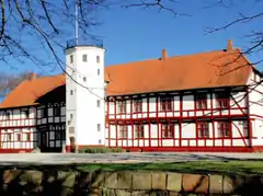 | Hovvasen 6, 4983 Dannemare | [5] | |
4895 Errindlev
| Listing name | Image | Location | Coordinates | Sescription |
|---|---|---|---|---|
| Errindlev tidl. Andelsmejeri | Errindlevvej 34B, 4895 Errindlev | [6] | ||
| Errindlevvej 34B, 4895 Errindlev | [7] | |||
| Errindlevvej 34B, 4895 Errindlev | [8] | |||
4900 Nakskov
| Listing name | Image | Location | Coordinates | Sescription |
|---|---|---|---|---|
| Axeltorv 1: Theisen House | Axeltorv 1, 4900 Nakskov | [9] | ||
| Havnegade 55, 4900 Nakskov | [10] | |||
| Havnegade 55, 4900 Nakskov | [11] | |||
| Axeltorv 3: Nakskov Pharmacy | Axeltorv 3, 4900 Nakskov | 54°49′48.49″N 11°8′9.2″E | Former pharmacy from 1777[12] | |
| Axeltorv 3, 4900 Nakskov | 54°49′48.12″N 11°8′9.2″E | Side wing from the 17th century[13] | ||
| Halsted Priory |  | Ullerslevvej 44, 4900 Nakskov | 54°50′47.41″N 11°13′31.99″E | Gothic Revival style main building from 1847-49[14] |
 | Ullerslevvej 42, 4900 Nakskov | 54°50′47.41″N 11°13′31.99″E | Queen Sofie's House: Old main building from 1589-91 by Hans von Andorf[15] | |
| Ullerslevvej 42, 4900 Nakskov | 54°50′47.41″N 11°13′31.99″E | Herskabsstalden: Stable from 1855.[16] | ||
| Ullerslevvej 42, 4900 Nakskov | 54°50′47.41″N 11°13′31.99″E | Stable from 1744[17] | ||
| Maribovej 248, 4900 Nakskov | 54°50′52.02″N 11°13′31.99″E | Hald-timbered house.[18] | ||
| Maribovej 250, 4900 Nakskov | 54°50′52.89″N 11°13′31.99″E | Havehuset: Half-timbered house from the beginning of the 19th century[19] | ||
| Maribovej 250, 4900 Nakskov | 54°50′52.89″N 11°13′31.99″E | Outbuilding.[20] | ||
| Maribovej 252, 4900 Nakskov | 54°50′53.17″N 11°13′31.99″E | Three-winged, half-timbered rehouse.[21] | ||
| Maribovej 252, 4900 Nakskov | 54°50′53.17″N 11°13′31.99″E | Outbuilding.[22] | ||
| Halsted Priory (Maribovej 281-289) | Maribovej 281, 4900 Nakskov | 54°50′52.27″N 11°13′38.73″E | [23] | |
| Maribovej 283, 4900 Nakskov | 54°50′52.6″N 11°13′38.73″E | [24] | ||
| Maribovej 283, 4900 Nakskov | 54°50′52.6″N 11°13′38.73″E | [25] | ||
| Maribovej 285, 4900 Nakskov | 54°50′52.46″N 11°13′38.73″E | [26] | ||
| Maribovej 285, 4900 Nakskov | 54°50′52.46″N 11°13′38.73″E | [27] | ||
| Maribovej 289, 4900 Nakskov | 54°50′53.2″N 11°13′38.73″E | [28] | ||
| Halsted Priory (Maribovej 291-297) | Maribovej 291, 4900 Nakskov | 54°50′54.59″N 11°13′59.16″E | [29] | |
| Maribovej 291, 4900 Nakskov | 54°50′54.59″N 11°13′59.16″E | [30] | ||
| Maribovej 293, 4900 Nakskov | 54°50′54.76″N 11°13′59.16″E | [31] | ||
| Maribovej 297, 4900 Nakskov | 54°50′54.87″N 11°13′59.16″E | [32] | ||
| Halsted Priory: The old inn | Maribovej 277, 4900 Nakskov | 54°50′50.42″N 11°13′30.45″E | [33] | |
| Halsted Priory: The old forge | Maribovej 279, 4900 Nakskov | 54°50′51.58″N 11°13′34.16″E | Former forge om brick from c. 1850[34] | |
| Maribovej 279, 4900 Nakskov | 54°50′51.58″N 11°13′34.16″E | Residential building for the smith from the early 10th century[35] | ||
| Kappel Windmill | 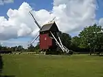 | Kappelvej 4C, 4900 Nakskov | 54°46′26.77″N 11°2′10.25″E | Post mill from c. 1730[36] |
| Købelev Rectory | Præstegårdsvej 42, 4900 Nakskov | 54°53′55.93″N 11°7′22.24″E | Rectory from 1769[37] | |
| N.E. Balles Barndomshjem | Vestenskov Kirkevej 4, 4900 Nakskov | [38] | ||
| Vestenskov Kirkevej 4, 4900 Nakskov | [39] | |||
| Nordenkirke 17 | Nordenkirke 17, 4900 Nakskov | 54°49′52.9″N 11°8′6.29″E | Building from 1857[40] | |
| Præstestræde 2 | Præstestræde 2A, 4900 Nakskov | [41] | ||
| Søndergade 25 | Søndergade 25, 4900 Nakskov | [42] | ||
| Queen's Warehouse | Havnegade 73, 4900 Nakskov | 54°49′43.4″N 11°8′16.01″E | Warehouse from c. 1600 of which one of the gables was replaced in the 19th century[43] | |
4913 Horslunde
| Listing name | Image | Location | Coordinates | Sescription |
|---|---|---|---|---|
| Reventlow Asylum | Pederstrupvej 3, 4913 Horslunde | [44] | ||
| Vindeby Windmill | 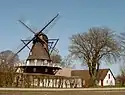 | Marrebæksvej 22, 4913 Horslunde | 54°55′14.19″N 11°8′27.64″E | Snick nill from c. 1800[45] |
4930 Maribo
| Listing name | Image | Location | Coordinates | Sescription |
|---|---|---|---|---|
| Bangshave |  | Meinckes Vej 1, 4930 Maribo | 54°46′14.33″N 11°29′29.11″E | Pavilion (Gammel Skovnæs Dairy) from 1853[46] |
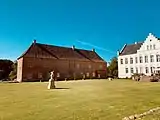
| Christianssæde | 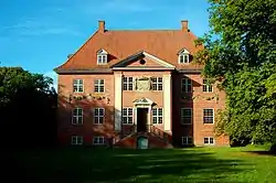 | Kristianssædevej 3, 4930 Maribo | 54°45′28.73″N 11°21′14.03″E | Main building from 1690 which was probably adapted in c. 1740 and again in 1878-84 and rebuilt after a fire in 1986[47] |
| Kapellanstræde 6 | Kapellanstræde 6, 4930 Maribo | 54°46′22.94″N 11°30′6.49″E | Townhouse from 1756[48] | |
| Kapellanstræde 8 | Kapellanstræde 8, 4930 Maribo | 54°46′22.72″N 11°30′6.56″E | Townhouse from 1756[49] | |
| Kapellanstræde 10 | Kapellanstræde 10, 4930 Maribo | 54°46′22.48″N 11°30′6.63″E | Townhouse from 1756[50] | |
| Kapellanstræde 12 | Kapellanstræde 12, 4930 Maribo | 54°46′22.21″N 11°30′6.68″E | Townhouse from 1756[51] | |
| Nørregades Bomhus, Maribo | Nørregade 17, 4930 Maribo | 54°46′33.43″N 11°29′59.96″E | Townhouse from 1756[52] | |
| Qvades Gård | Torvet 3, 4930 Maribo | 54°46′28.63″N 11°30′5.41″E | Main building from 1819[53] | |
| Torvet 3, 4930 Maribo | 54°46′28.63″N 11°30′5.41″E | Galf-timbered side wing[54] | ||
| Jernbanegade 7, 4930 Maribo | 54°46′31.5″N 11°30′5.41″E | Warehouse from 1852[55] | ||
| Søholt. Skelsnæspavillon | Søholtvej 28, 4930 Maribo | 54°44′56.48″N 11°33′12.57″E | Townhouse from 1756[56] | |
| Torvet 24, Maribo | Torvet 24, 4930 Maribo | 54°46′24.12″N 11°30′6.15″E | Townhouse from 1756[57] | |
| Kapellanstræde 2, 4930 Maribo | 54°46′23.55″N 11°30′6.15″E | Townhouse from 1756[58] | ||
4941 Bandholm
| Listing name | Image | Location | Coordinates | Sescription |
|---|---|---|---|---|
| Bandholm Jernbanestation | 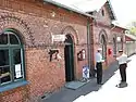 | Stationsvej 10, 4941 Bandholm | 54°50′8.65″N 11°28′55.5″E | Station building from 1869-70[59] |
| Birketvej 64-66 | Birketvej 64, 4941 Bandholm | 54°50′9.8″N 11°28′30.48″E | 16 bays long and six bays wide half-timbered building from the middle of the 18th century and the hedging along Birketvej and Smedestræde[60] | |
| Hvedemagasinet, Bandholm | Havnegade 23, 4941 Bandholm | 54°50′6.19″N 11°29′2.39″E | Two-storey storage building from the middle of the 19th century[61] | |
4812 Harpelund
| Listing name | Image | Location | Coordinates | Sescription |
|---|---|---|---|---|
| Frederiksdal | Frederiksdalsvej 30, 4912 Harpelunde | [62] | ||
| Frederiksdalsvej 30, 4912 Harpelunde | [63] | |||
4920 Søllested
| Listing name | Image | Location | Coordinates | Sescription |
|---|---|---|---|---|
| Ålstrup | 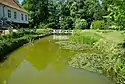 | Rødbyvej 45, 4920 Søllested | 54°46′11.03″N 11°18′7.85″E | Half-timbered building from c. 1780[64] |
4943 Torrig L
| Listing name | Image | Location | Coordinates | Sescription |
|---|---|---|---|---|
| Magletving Møllevej 23 | Mageltving Møllevej 23, 4943 Torrig L | [65] | ||
| Mageltving Møllevej 23, 4943 Torrig L | [66] | |||
| Pederstrup | 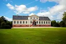 | Pederstrupvej 124, 4943 Torrig L | 54°53′45.34″N 11°15′55.85″E | Neoclassical manor house from 1813-22 by Christian Frederik Hansen[67] |
4944 Fejø
| Listing name | Image | Location | Coordinates | Sescription |
|---|---|---|---|---|
| Herredsvej 281 | Herredsvej 281, 4944 Fejø | 54°57′5.53″N 11°25′59.98″E | Half-timbered building from c. 1780[68] | |
4951 Nørreballe
| Listing name | Image | Location | Coordinates | Sescription |
|---|---|---|---|---|
| Østofte Mølle | 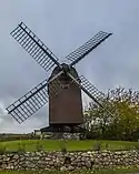 | Østofte Møllevej 262, 4951 Nørreballe | [69] | |
| Østofte Rectory | Østofte Gade 36, 4951 Nørreballe | [70] | ||
| Østofte Gade 36, 4951 Nørreballe | [71] | |||
| Østofte Gade 36, 4951 Nørreballe | [72] | |||
4953 Vesterborg
| Listing name | Image | Location | Coordinates | Sescription |
|---|---|---|---|---|
| Søgaard | Søvej 4, 4953 Vesterborg | [73] | ||
| Søvej 4, 4953 Vesterborg | [74] | |||
4960 Holeby
| Listing name | Image | Location | Coordinates | Sescription |
|---|---|---|---|---|
| Kapellanboligen | Kirkevej 4, 4960 Holeby | [75] | ||
| Kirkevej 4, 4960 Holeby | [76] | |||
| Kærstrup | 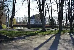 | Kærstrupvej 17, 4960 Holeby | 54°41′33.2″N 11°31′36.49″E | Main building from 1765 /older cellar) which was adapted in 1836 and tower from 1868[77] |
4970 Rødby
| Listing name | Image | Location | Coordinates | Description |
|---|---|---|---|---|
| Højbygård | Højbygårdvej 20A, 4970 Rødby | [78] | ||
| Højbygårdvej 20A, 4970 Rødby | [79] | |||
| Højbygårdvej 20A, 4970 Rødby | [80] | |||
| Højbygårdvej 20A, 4970 Rødby | [81] | |||
| Højbygårds Skovløberhus | Højbygårdvej 22, 4970 Rødby | 54°41′28.07″N 11°27′3.7″E | Residential building from c. 1850[82] | |
| Lungholm | Rødbyvej 22, 4970 Rødby | [83] | ||
| Rødbyvej 24, 4970 Rødby | [84] | |||
| Østergade 65, Rødby | Østergade 65, 4970 Rødby | [85] | ||
| Tågerup Polakkaserne | Højbygårdvej 34, 4970 Rødby | [86] | ||
| Willer House | 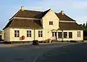 | Vestergade 1, 4970 Rødby | 54°41′43.6″N 11°23′14.9″E | House from 1729[87] |
Delisted buildings
| Listing name | Image | Location | Coordinates | Description |
|---|---|---|---|---|
| Sæbyholm | Maribovej 238, 4900 Nakskov | 54°50′3.25″N 11°11′30.09″E | Townhouse from 1756[88] | |
| Maribovej 238, 4900 Nakskov | 54°50′3.25″N 11°11′30.09″E | Townhouse from 1756[89] | ||
| Søndergades Bomhus, Maribo | Søndergade 38, 4930 Maribo | 54°46′20.05″N 11°30′12.11″E | Boom house from 1820-21[90] | |
References
- "FBB - sag".
- "FBB - sag".
- "FBB - sag".
- "FBB - sag".
- "FBB - sag".
- "FBB - sag".
- "FBB - sag".
- "FBB - sag".
- "FBB - sag".
- "FBB - sag".
- "FBB - sag".
- "FBB - sag".
- "FBB - sag".
- "FBB - sag".
- "FBB - sag".
- "FBB - sag".
- "FBB - sag".
- "FBB - sag".
- "FBB - sag".
- "FBB - sag".
- "FBB - sag".
- "FBB - sag".
- "FBB - sag".
- "FBB - sag".
- "FBB - sag".
- "FBB - sag".
- "FBB - sag".
- "FBB - sag".
- "FBB - sag".
- "FBB - sag".
- "FBB - sag".
- "FBB - sag".
- "FBB - sag".
- "FBB - sag".
- "FBB - sag".
- "FBB - sag".
- "FBB - sag".
- "FBB - sag".
- "FBB - sag".
- "FBB - sag".
- "FBB - sag".
- "FBB - sag".
- "FBB - sag".
- "FBB - sag".
- "FBB - sag".
- "FBB - sag".
- "FBB - sag".
- "FBB - sag".
- "FBB - sag".
- "FBB - sag".
- "FBB - sag".
- "FBB - sag".
- "FBB - sag".
- "FBB - sag".
- "FBB - sag".
- "FBB - sag".
- "FBB - sag".
- "FBB - sag".
- "FBB - sag".
- "FBB - sag".
- "FBB - sag".
- "FBB - sag".
- "FBB - sag".
- "FBB - sag".
- "FBB - sag".
- "FBB - sag".
- "FBB - sag".
- "FBB - sag".
- "FBB - sag".
- "FBB - sag".
- "FBB - sag".
- "FBB - sag".
- "FBB - sag".
- "FBB - sag".
- "FBB - sag".
- "FBB - sag".
- "FBB - sag".
- "FBB - sag".
- "FBB - sag".
- "FBB - sag".
- "FBB - sag".
- "FBB - sag".
- "FBB - sag".
- "FBB - sag".
- "FBB - sag".
- "FBB - sag".
- "FBB - sag".
- "FBB - sag".
- "FBB - sag".
- "FBB - sag".
External links
Wikimedia Commons has media related to Listed buildings in Lolland Kommune.
This article is issued from Wikipedia. The text is licensed under Creative Commons - Attribution - Sharealike. Additional terms may apply for the media files.