Listed buildings in Næstved Municipality
This is a list of listed buildings in Næstved Municipality, Denmark.
The list
4160 Herlufmagle
| Listing name | Image | Location | Coordinates | Description |
|---|---|---|---|---|
| Gunderslevholm | Gunderslevvej 17, 4160 Herlufmagle | 55°18′54.48″N 11°40′18.93″E | Main building from 1729 which was adapted in 1787.[1] | |
| Tybjerggaard | Tybjergvej 20, 4160 Herlufmagle | 1763 | Three-winged main building from 1763 with cellar from the Middle Ages under the East Wing.[2] | |
| Viborggård | Fensmarkvej 9, 4160 Herlufmagle | 55°18′10.09″N 11°46′33.45″E | Main building from the 18th century[3] | |
4171 Glumsø
| Listing name | Image | Location | Coordinates | Sescription |
|---|---|---|---|---|
| Glumsø Rectory | Storegade 24, 4171 Glumsø | 1838 | Residential wing from 1838.[4] | |
| Storegade 24, 4171 Glumsø | Three-winged complex of farm buildings-[5] | |||
4250 Fuglebjerg
| Listing name | Image | Location | Coordinates | Sescription |
|---|---|---|---|---|
| Førslevgaard | Førslevvej 54, 4250 Fuglebjerg | 55°16′40.52″N 11°34′42.46″E | Three-winged main building from 1726[6] | |
| Tystrup Rectory | Bakkegårdsvej 2, 4250 Fuglebjerg | 55°21′42.67″N 11°33′47.35″E | The half-timbered east wing from the first half of the 19th century[7] | |
4262 Sandved
| Listing name | Image | Location | Coordinates | Sescription |
|---|---|---|---|---|
| Fuirendal | Fyrendalvej 14, 4262 Sandved | 55°14′57.46″N 11°30′43.82″E | Main building from 1609[8] | |
| Fyrendalvej 14A, 4262 Sandved | 55°14′58.45″N 11°30′43.18″E | Gate wing from c. 1610[9] | ||
4684 Holmegaard
| Listing name | Image | Location | Coordinates | Sescription |
|---|---|---|---|---|
| Fensmark Rectory | Chr Winthersvej 2, 4684 Holmegaard | Residential wing from 1837 and a three-winged complex of farm buildings from c. 1775.[10] | ||
| Chr Winthersvej 2, 4684 Holmegaard | [11] | |||
| Chr Winthersvej 2, 4684 Holmegaard | [12] | |||
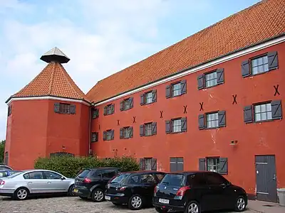
| Holmegård | .jpg.webp) | Holmegaard Hovedbygning 1, 4684 Holmegaard | 55°16′28.37″N 11°50′14.72″E | Three-winged main building from 1635 with extension on the north side[13] |
| Sparresholm | 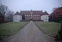 | Sparresholmvej 4, 4684 Holmegaard | 1798 | Three-winged manor house from 1699.[14] |
4700 Næstved
| Listing name | Image | Location | Coordinates | D
escription |
|---|---|---|---|---|
| Brogade 2: Wittusen House | 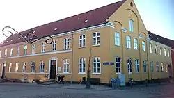 | Brogade 2A, 4700 Næstved | 55°13′51.43″N 11°45′17.98″E | House on Brogade and warehouse wing on Møllegade[15] |
 | Møllegade 7A, 4700 Næstved | 55°13′51.16″N 11°45′16.21″E | Detached warehouse[16] | |
| Næstved Cavalry Barracks | Grønnegade 10T, 4700 Næstved | 1888 | The New Eiding Hall from 1888.[17] | |
| Grønnegade 10T, 4700 Næstved | 1855 | The old fencing hall from 1855-[18] | ||
| Grønnegade 10D, 4700 Næstved | 1855 | Residential quarters from 1847.[19] | ||
| Grønnegade 10, 4700 Næstved | 1799 | The Old Riding Hall from 1799 with exposed timber framing [20] | ||
| Grønnegade 10, 4700 Næstved | 1847 | Stables from 1847[21] | ||
| Dom- og arresthuset - det tidl. rådhus i Næstved | 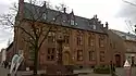 | Hjultorv 2, 4700 Næstved | 1856 | Tinghuset: Former town hall from 1855-56 by Michael Gottlieb Bindesbøll, jailhouse with courtyards, wall on Hjultorv from 1855-56 by Gottlieb Bindesbøll) and the yard behind it.[22] |
| Ramsherred 2, 4700 Næstved | 1938 | Extension of Tinghuset from 1938 by Johannes Tidemand-Dal.[23] | ||
| Gavnø | 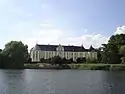 | Gavnø 2, 4700 Næstved | 55°11′19.78″N 11°43′30.55″E | The three-winged main building originally built in c. 1400 but heavily adapted in 1755 probably by Jacob Fortling[24] |
| Gavnø: Gardener's House | Gavnø 11, 4700 Næstved | c. 1800 | House from c. 1800.[25] | |
| Gavnø 13, 4700 Næstved | Stables.[26] | |||
| Hammershus | Byvej 11, 4700 Næstved | House with clay walls from c. 1813.[27] | ||
| Byvej 11, 4700 Næstved | House with clay walls from c. 1813.[28] | |||
| Byvej 11A, 4700 Næstved | House with clay walls from c. 1813.[29] | |||
| Byvej 11B, 4700 Næstved | House with clay walls from c. 1813.[30] | |||
| Byvej 11C, 4700 Næstved | House with clay walls from c. 1813.[31] | |||
| Harrestedgård | Slagelsevej 283C, 4700 Næstved | 55°14′52.84″N 11°30′47.72″E | Building from the Middle Ages and the 1840s[32] | |
| Herlufsholm | Herlufsholm Alle 170, 4700 Næstved | [33] | ||
| Herlufsholm Alle 170, 4700 Næstved | [34] | |||
| Herlufsholm Alle 170, 4700 Næstved | [35] | |||
| Herlufsholm Alle 170, 4700 Næstved | [36] | |||
| Herlufsholm Alle 170, 4700 Næstved | [37] | |||
| Herlufsholm Alle 170, 4700 Næstved | [38] | |||
| Herlufsholm Alle 170, 4700 Næstved | [39] | |||
| House of the Holy Ghost | 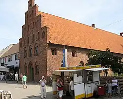 | Ringstedgade 4A, 4700 Næstved | 55°13′56.33″N 11°45′30.25″E | Building from c. 1420[40] |
| Hotel Axelhus | 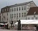 | Axeltorv 9A, 4700 Næstved | 55°13′50.92″N 11°45′27.64″E | Building from 1784 but later expanded with an extra floor[41] |
| Hotel Vinhuset | 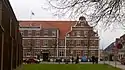 | Sct Peders Kirkeplads 4, 4700 Næstved | 55°13′50.92″N 11°45′27.64″E | The buildings facing Kirkepladsen and Vinhusstræde from 1778 and later as well as the vaulted cellar from c. 1500[42] |
| Kompagnihuset | 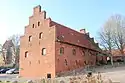 | Kompagnistræde 3, 4700 Næstved | 55°13′44.93″N 11°45′28.42″E | Building from c. 1500 and the attached half-timbered building.[43] |
| Næstved Old Town Hall | .jpg.webp) | Sct Peders Kirkeplads 5A, 4700 Næstved | Gothic style former town hall from c. 1450 and c. 1520.[44] | |
| Ostenfeldts Stiftelse | Ostenfeldtsvej 7, 4700 Næstved | [45] | ||
| Ostenfeldtsvej 7, 4700 Næstved | [46] | |||
| Riddergade 1 A | .jpg.webp) | Riddergade 1A, 4700 Næstved | [47] | |
| Riddergade 1A, 4700 Næstved | [48] | |||
| Riddergade 3: Ridderhuset | 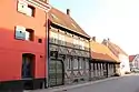 | Riddergade 3, 4700 Næstved | 55°13′45.26″N 11°45′35.65″E | House from 1589[49] |
| Riddergade 5: Apostelhuset | 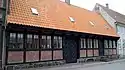 | Riddergade 5A, 4700 Næstved | 55°13′45.04″N 11°45′35.36″E | Building from the 1410s[50] |
| Riddergade 7 | Riddergade 7, 4700 Næstved | Building on Riddergade and the side wing along Slagkildevej.[51] | ||
| Rønnebæksholm: Grundtvig's Pavilion | .jpg.webp) | Rønnebæksholm 1, 4700 Næstved | 55°13′12.32″N 11°47′39.93″E | Pavilion from 1852 designed by J. D. Herholdt and associated with N. F. S. Grundtvig[52] |
| Saltø | Saltøvej 59, 4700 Næstved | 55°13′37.85″N 11°37′56.53″E | Two-winged main building of which the eastern part of the north wing dates from the Late Middle Ages and the western part of the north wing and the east wing date from the second half of the 16th century[53] | |
| Saltøvej 59, 4700 Næstved | 55°13′37.85″N 11°37′56.53″E | Half-timbered wing from the 18th century[54] | ||
| Saltøvej 59, 4700 Næstved | 55°13′37.85″N 11°37′56.53″E | Half-timbered wing from the 18th century[55] | ||
| Sankt Peders Kirkeplads 3 og Kirkestræde 3 | 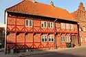 | Sct Peders Kirkeplads 3, 4700 Næstved | [56] | |
| Kirkestræde 3, 4700 Næstved | [57] | |||
| Stenboderne | 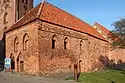 | Sct Peders Kirkeplads 8, 4700 Næstved | [58] | |
.jpg.webp) | Sct Peders Kirkeplads 10, 4700 Næstved | [59] | ||
.jpg.webp) | Sct Peders Kirkeplads 12, 4700 Næstved | [60] | ||
4733 Tappernøje
| Listing name | Image | Location | Coordinates | Sescription |
|---|---|---|---|---|
| Bækkeskov | Bækkeskov Alle 1, 4733 Tappernøje | 55°11′26.35″N 12°0′54.42″E | Main building from 1796-98[61] | |
| Borrehøjgård | Teglværksvej 4, 4733 Tappernøje | 55°9′23.02″N 11°56′45.75″E | Former residence of the local mayor dating from c. 1730 but later expanded with 3 bays[62] | |
| Engelholm | 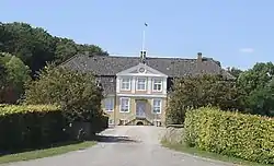 | Engelholmvej 3, 4733 Tappernøje | 55°8′28.06″N 11°58′54.46″E | Main building from 1781-85[63] |
| Snesere Rytterskole | Bårsevej 4, 4733 Tappernøje | 55°9′50.99″N 11°55′53.66″E | A so-called rytterskole from 1724[64] | |
| Snesere Tromlehus | Bårsevej 3D, 4733 Tappernøje | 1798 | Sprøjte- og tromlehuset from c. 1928 designed by Julius Rasmussen-[65] | |
4736 Karrebæksminde
| Listing name | Image | Location | Coordinates | Sescription |
|---|---|---|---|---|
| Karrebæk Windmill | 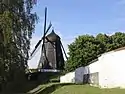 | Karrebækvej 852, 4736 Karrebæksminde | 55°11′31.61″N 11°30′18.28″E | Smock mill from c. 1860[66] |
References
- "FBB - sag".
- "FBB - sag".
- "FBB - sag".
- "Systemfejl".
- "Systemfejl".
- "FBB - sag".
- "FBB - sag".
- "FBB - sag".
- "FBB - sag".
- "FBB - sag".
- "FBB - sag".
- "Sag: Fensmark Præstegård, Christian Winthersvej 2, Næstved".
- "FBB - sag".
- "FBB - sag".
- "FBB - sag".
- "FBB - sag".
- "FBB - sag".
- "FBB - sag".
- "FBB - sag".
- "FBB - sag".
- "Systemfejl".
- "Systemfejl".
- "FBB - sag".
- "FBB - sag".
- "FBB - sag".
- "Systemfejl".
- "FBB - sag".
- "FBB - sag".
- "FBB - sag".
- "FBB - sag".
- "FBB - sag".
- "FBB - sag".
- "FBB - sag".
- "FBB - sag".
- "FBB - sag".
- "FBB - sag".
- "FBB - sag".
- "FBB - sag".
- "FBB - sag".
- "FBB - sag".
- "FBB - sag".
- "FBB - sag".
- "Systemfejl".
- "FBB - sag".
- "FBB - sag".
- "FBB - sag".
- "FBB - sag".
- "FBB - sag".
- "FBB - sag".
- "FBB - sag".
- "Systemfejl".
- "FBB - sag".
- "FBB - sag".
- "FBB - sag".
- "FBB - sag".
- "FBB - sag".
- "FBB - sag".
- "FBB - sag".
- "FBB - sag".
- "FBB - sag".
- "FBB - sag".
- "FBB - sag".
- "FBB - sag".
- "FBB - sag".
- "Systemfejl".
- "FBB - sag".
External links
Wikimedia Commons has media related to Listed buildings in Næstved Kommune.
This article is issued from Wikipedia. The text is licensed under Creative Commons - Attribution - Sharealike. Additional terms may apply for the media files.