Lucaswolde
Lucaswolde (Dutch pronunciation: [ˌly.kɑsˈʋɔl.də]) is a linear village in the municipality of Westerkwartier in the province of Groningen in the Netherlands. The village is located between Marum and Boerakker. As of 2021, it had a population of 195.[1]
Lucaswolde | |
|---|---|
Village | |
 Landscape near Lucaswolde | |
 Flag  Coat of arms | |
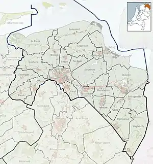
 Lucaswolde Location in the province of Groningen in the Netherlands  Lucaswolde Lucaswolde (Netherlands) | |
| Coordinates: 53°11′N 6°18′E | |
| Country | |
| Province | |
| Municipality | |
| Area | |
| • Total | 4.87 km2 (1.88 sq mi) |
| Elevation | 0.3 m (1.0 ft) |
| Population (2021)[1] | |
| • Total | 195 |
| • Density | 40/km2 (100/sq mi) |
| Time zone | UTC+1 (CET) |
| • Summer (DST) | UTC+2 (CEST) |
| Postcode | 9825[1] |
| Area code | 0594 |
Just south of the region, on the Dwarsdiep, is a nature reserve in the Oude Riet polder. This is a popular place, especially for bird watchers.
History
This part of the Westerkwartier consisted of wildland, owned by the farmers of Marum, Niebert and Nuis. There were some scattered buildings, which were only accessible from Noordwijk. This remained the case well into the nineteenth century. Only in 1878 was a sand path built to Boerakker.
In the Middle Ages, the village had its own village church, dating from the twelfth or thirteenth century, which fell into disrepair around 1540.[3] In 1596 no one lived there anymore. The parish was merged with Noordwijk, but the lands of the church and presbytery continued to have their own managers. The cemetery still existed in the 19th century. Now this is a farmyard (at Hooiweg 11).
In 1528 the Dominican nuns of Oosterreide bought land here. The Susteren van Reyde ('Sisters of Reide') were looking for a new place to live because of the floods in the Dollart area and had a monastic grange or uythof built in Lucaswolde, which still existed in 1539.
The flag and coat of arms of Lucaswolde have been applied by both the villages of Boerakker and Lucaswolde in 2009, which are sometimes referred to conjointly as 'Boerakker-Lucaswolde' because of their relative proximity.
References
- "Kerncijfers wijken en buurten 2021". Statistics Netherlands. Retrieved 1 September 2023.
- "Postcodetool for 9827PC". Actueel Hoogtebestand Nederland (in Dutch). Het Waterschapshuis. Retrieved 1 September 2023.
- Roemeling, O.D.J. (2019). "Patroonheiligen, priesters en predikanten in Groningen en Drenthe tot omstreeks 1640, zeer voorlopige versie" (PDF). Leeuwarden. pp. 486–487.
External links
![]() Media related to Lucaswolde at Wikimedia Commons
Media related to Lucaswolde at Wikimedia Commons