Lugano Prealps
The Lugano Prealps (Prealpi Luganesi or Prealpi Lombarde Occidentali in Italian) are a mountain range in the western part of the Alps. They are located in Canton Ticino (southern Switzerland) and Lombardy (northern Italy).
| Lugano Prealps | |
|---|---|
| Prealpi Lombarde Occidentali | |
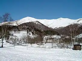 Monte San Primo in winter from Pian del Tivano | |
| Highest point | |
| Peak | Pizzo di Gino |
| Elevation | 2,245 m (7,365 ft) |
| Coordinates | 46°06′03″N 9°12′20″E |
| Naming | |
| Native name | Prealpi Luganesi (Italian) |
| Geography | |
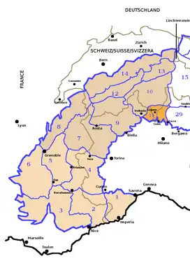 Lugano Prealps (section no. 11) within the Western Alps
| |
| Countries | Switzerland and Italy |
| Canton, Region | Ticino and Lombardy |
| Parent range | Alps |
| Borders on | Bergamasque Alps and Prealps, Lepontine Alps, Western Rhaetian Alps and Po plain |
| Geology | |
| Orogeny | Alpine orogeny |
| Type of rock | Sedimentary rocks[1] |
Geography
Administratively the Italian part of the range belongs to the provinces of Como and Varese, while the Swiss one is divided between the districts of Bellinzona, Locarno, Lugano and Mendrisio.

The western slopes of the mountains are drained by the Ticino, the eastern ones by Adda and the southern-central part of them by Lambro, Olona and other minor rivers and streams, all of them directly or indirectly tributaries of the Po.
SOIUSA classification
According to SOIUSA (International Standardized Mountain Subdivision of the Alps) the mountain range is an Alpine section, classified in the following way:[2]
- main part = Western Alps
- major sector = North Western Alps
- section = Lugano Prealps
- code = I/B-11
Borders
Lugano Prealps' borders are (clockwise):
- Lago Maggiore (west),
- Ticino from Locarno to Bellinzona, San Jorio Pass (2.010 m, which connects them with the Lepontine Alps) and San Jorio valley till to Gravedona (north);
- Como lake (east);
- Po Plain (south).
Subdivision
The Lugano Prealps are divided into two subsections:[2]
- Como Prealps - SOIUSA code:I/B-11.I
- Varese Prealps - SOIUSA code:I/B-11.II,
which are separated by the Monte Ceneri Pass.
These subsections are further divided in supergroups:
- Como Prealps:
- supergroup catena Gino-Camoghè-Fiorina - SOIUSA code:I/B-11.I-A
- supergroup catena Tremezzo-Generoso-Gordona - SOIUSA code:I/B-11.I-B
- supergroup catena del Triangolo Lariano - SOIUSA code:I/B-11.I-B
- Varese Prealps:
- supergroup catena Tamaro-Gambarogno-Lema - SOIUSA code:I/B-11.II-A,
- supergroup catena Piambello-Campo dei Fiori-Nudo - SOIUSA code:I/B-11.II-B.
Summits
The chief summits of the range are:
| Name | metres | feet |
|---|---|---|
| Pizzo di Gino | 2,245 | 7,363 |
| Camoghè | 2,226 | 7,301 |
| Gazzirola | 2,116 | 6,940 |
| Monte Bregagno | 2,107 | 6,910 |
| Monte Tamaro | 1,967 | 6,451 |
| Monte Gradiccioli | 1,936 | 6,352 |
| Monte Grona | 1,736 | 5,694 |
| Monte Generoso | 1,704 | 5,589 |
| Monte di Tremezzo | 1,700 | 5,600 |
| Monte San Primo | 1,685 | 5,526 |
| Monte Lema | 1,621 | 5,316 |
| Corni di Canzo | 1,373 | 4,503 |
| Sighignola | 1,314 | 4,311 |
| Monte Nudo | 1,235 | 4,050 |
| Monte Pian Nave | 1,058 | 3,471 |
| Monte Minisfreddo | 1,047 | 3,435 |
| Poncione di Ganna | 993 | 3,258 |
| Monte Chiusarella | 913 | 2,995 |
| Colle di Brianza | 877 | 2,877 |
| Monte Monarco | 858 | 2,815 |
References
- VV. AA. (1999). Lombardia : esclusa Milano (in Italian). Touring Club Italiano. p. 37.
- Marazzi, Sergio (2005). Atlante Orografico delle Alpi. SOIUSA (in Italian). Priuli & Verlucca. ISBN 978-88-8068-273-8.
Maps
- Italian official cartography (Istituto Geografico Militare - IGM); on-line version: www.pcn.minambiente.it
- Swiss official cartography (Swiss Federal Office of Topography - Swisstopo); on-line version: map.geo.admin.ch
| Western Alps |
| ||||||
|---|---|---|---|---|---|---|---|
| Eastern Alps |
| ||||||