Luis Arcos Bergnes, Cuba
Luis Arcos Bergnes also known as Carmita is a small town and a ward (consejo popular) in Camajuani, Villa Clara, Cuba. With a population of 2,279 it is considered a village.[2]
Carmita | |
|---|---|
| Luis Arcos Bergnes | |
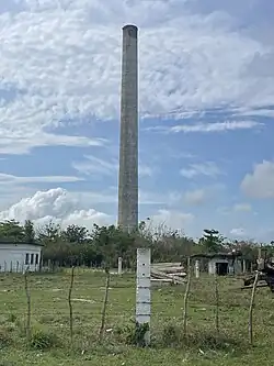 the CAI of Luis Arcos Bergnes | |
.png.webp) Map of Carmita (Red) in Camajuaní (Orange) in Villa Clara (Yellow) | |
.svg.png.webp) Where Carmita is in Cuba 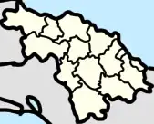 Luis Arcos Bergnes, Cuba (Villa Clara Province)  Luis Arcos Bergnes, Cuba (Camajuaní) | |
| Coordinates: 22°30′18″N 79°48′57″W | |
| Country | Cuba |
| Province | Villa Clara |
| Municipality | Camajuani |
| Named for | Luis Arcos Bergnes (brother of Sebastian Arcos Bergnes) |
| Government | |
| • President | Martín Sánchez Rodríguez [1] (Non-partisan) |
| Population | |
| • Total | 2,279 [2] |
Nearby towns of Carmita are La Luz, Corona, El Cubano, Romano, La Mano, and Vega Alta.[3]
Geography
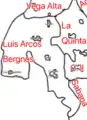 Map of the Ward of Luis Arcos Bergnes
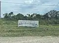 Sign stating the entrance of the Ward
Wards of Cuba are a local body of a town and some towns nearby. Towns in Luis Arcos Bergnes’ ward include
- La Luz
- Fusté
- Crucero Carmita
- Reparto Viejo
- Reparto Nuevo
- El Charco[4]
- Pueblo Nuevo
- Batey Viejo
Economy
According at the DMPF (Departamento de control de la Dirección Municipal de Planificación Física or Management Control Department Municipal Physical Planning in English) of Camajuani, Luis Arcos Bergnes is a settlement linked to sources of employment or economic development.[5]
In order to make charcoal in Camajuani you need to live in Luis Arcos Bergnes or Taguayabón.[6]

UBPC and CCS in the ward include:
- UBPC Máximo Gómez Báez (La Luz)
- UBPC Máximo Gómez (South of the village of Luis Arcos Bergnes)
- CCS Antonio Maceo (La Luz)
- CCS Salomé Hernandez (Fusté)
History
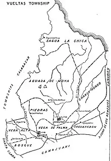
Carmita used to be a part of the barrio of Vega Alta, in the former municipality of Vueltas.
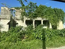
Carmita has an abandoned house on the Carretera a Luis Arcos Bergnes, it is said to be the house of Fulgencio Batista, one of his friends, or the house of Gerardo Machado.
Transportation
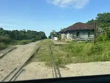
Carmita is on a railine starting in Santa Clara, going to Crucero Margot, to Luis Arcos Bergnes, Vega Alta, Canoa, Tuinicu, Constancia, Encrucijada, Mata, El Vaquerito, Aguada la Piedra, Cifuentes, San Diego del Valle, Conyedo, and finally back to Santa Clara.[7][8]
Education
In the ward there are a few schools, these include:[9]
- Luis A. Bergnes Primary
- Julio Pino Primary (Crucero Carmita)
- Delfín Sen Cedré Primary (La Luz)
- Escuela Tony Alomá (Fuste) [10]
References
- "Batey Carmita, el poblado cubano que pasó de la prosperidad al hambre cuando perdió su central". cubacute.com (in Spanish). 5 May 2022.
- "Camajuaní (Municipality, Villa Clara Province, Cuba) - Population Statistics, Charts, Map and Location".
- "List of Cities near Carmita in Villa Clara, Cuba". www.gomapper.com. Retrieved 2022-06-30.
- Zerquera, Idalia Vázquez. "Camajuaní: el empeño de un pueblo por vencer los retos". Vanguardia (in European Spanish). Retrieved 2023-06-11.
- Barroso, Joel Jiménez; Figueroa Vidal, Dr. Arq. Carlos. R. "Diagnóstico estratégico de la situación habitacional del municipio de Camajuaní" (PDF). p. 67.
- "Empleo". Portal del Ciudadano en Camajuaní (in European Spanish). Retrieved 2022-12-31.
- lezumbalaberenjena (2017-11-09), Composed road map from a tour guide (1980's), retrieved 2023-04-12
- "Road guides of Cuba" (PDF). 2019.
- "Portal del Ciudadano en Camajuaní - Educación". www.soycamajuani.gob.cu. Retrieved 2022-12-23.
- "El conocimiento de la historia local en los escolares de la escuela primaria Luis Arcos Bergnes" (PDF). University "Marta Abreu" of Las Villas. p. 57.