Lumajang Regency
Lumajang Regency is a Regency (kabupaten) located in the East Java province of Indonesia. It covers an area of 1,790.90 sq. km, and had a population of 1,006,458 at the 2010 Census[2] and 1,119,251 at the 2020 Census.[3] The mid 2022 official estimate as originally stated to be 1,137,230, but was revised down to 1,097,504 (comprising 544,410 males and 553,094 females).[1] The regency shares its land borders with Jember Regency (to the east), Probolinggo Regency (to the north), and Malang Regency (to the west), while it borders the Indian Ocean to the south.
Lumajang Regency | |
|---|---|
 | |
 Coat of arms | |
| Motto(s): Amreta Brata Wira Bhakti (Eternal virtue by act of gallantry and devotion) | |
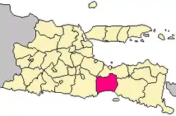 Location within East Java | |
| Coordinates: 8°08′S 113°13′E | |
| Country | Indonesia |
| Province | East Java |
| Capital | Lumajang |
| Government | |
| • Regent | Thoriqul Haq, M.ML. |
| • Vice Regent | Indah Amperawati |
| Area | |
| • Total | 1,790.90 km2 (691.47 sq mi) |
| Population (mid 2022 estimate) | |
| • Total | 1,097,504 |
| • Density | 610/km2 (1,600/sq mi) |
| [1] | |
| Time zone | UTC+7 (IWST) |
| Area code | (+62) 334 |
| Website | lumajangkab |

Geography
Lumajang is located approximately 150 km southeast of Surabaya. Its temperature ranges between 24 °C to 32 °C.
History
Lumajang is one of the ancient cities in Java which still exist up to this day.[4] According to Mula Malurung artifact (dated 1177 Saka), Lumajang was then ruled by King Nararyya Kirana Sminingrat. The date of the artifact, which is 15 December 1255 in the Gregorian calendar, was decided as the date of establishment of Lumajang. Menhirs found in the districts of Senduro, Gucialit, Sukodono, Klakah, and Lumajang reveal that in prehistoric times, the present area of Lumajang had already been inhabited long before the date of Mula Malurung artifact.[4]
Administrative districts
Lumajang Regency is divided into 21 districts (kecamatan), tabulated below with their areas and their populations at the 2010 Census[2] and the 2020 Census,[3] together with the official estimates as at mid 2022.[1] The table also includes the numbers of administrative villages in each district (totalling 198 rural desa and 7 urban kelurahan - the latter all in Lumajang (town) District), and the post codes.
| Name of District (kecamatan) | Area in km2 | Pop'n Census 2010 | Pop'n Census 2020 | Pop'n Estimate mid 2022 | No. of villages | Post code |
|---|---|---|---|---|---|---|
| Tempursari | 105.35 | 28,501 | 33,819 | 33,547 | 7 | 67375 |
| Pronojiwo | 141.49 | 31,737 | 37,759 | 37,679 | 6 | 67374 |
| Candipuro | 143.09 | 62,226 | 73,617 | 72,405 | 10 | 67373 |
| Pasirian | 128.39 | 83,683 | 92,035 | 89,303 | 11 | 67372 |
| Tempeh | 73.21 | 78,806 | 85,929 | 84,078 | 13 | 67371 |
| Lumajang (town) | 28.47 | 80,685 | 84,649 | 33,547 | 12 (a) | 67316 (b) |
| Sumbersuko | 29.07 | 33,913 | 36,137 | 36,199 | 8 | 67316 |
| Tekung | 27.88 | 32,565 | 35,565 | 35,154 | 8 | 67381 |
| Kunir | 53.30 | 51,679 | 56,181 | 55,663 | 11 | 67383 |
| Yosowilangun | 72.44 | 56,546 | 61,299 | 60,016 | 12 | 67382 |
| Rowokangkung | 58.88 | 34,149 | 38,391 | 37,791 | 7 | 67359 |
| Jatiroto | 53.69 | 45,247 | 48,226 | 47,367 | 6 | 67355 |
| Randuagung | 93.92 | 60,853 | 70,343 | 68,581 | 12 | 67354 |
| Sukodono | 28.81 | 49,949 | 56,352 | 55,927 | 10 | 67351 |
| Padang | 53.83 | 34,615 | 37,943 | 37,097 | 9 | 67352 |
| Pasrujambe | 162.47 | 34,916 | 40,987 | 40,644 | 7 | 67361 |
| Senduro | 170.90 | 42,892 | 49,314 | 49,390 | 12 | 67362 |
| Gucialit | 101.79 | 23,436 | 26,274 | 25,831 | 9 | 67353 |
| Kedungjajang | 66.13 | 43,499 | 47,685 | 45,862 | 12 | 67358 |
| Klakah | 87.42 | 51,118 | 56,664 | 53,840 | 12 | 67356 |
| Ranuyoso | 110.36 | 45,443 | 50,082 | 46,899 | 11 | 67357 |
| Totals | 1,790.90 | 1,006,458 | 1,119,251 | 1,097,504 | 205 |
Notes: (a) comprising 7 urban kelurahan and 5 rural desa. (b) except the kelurahan of Tompokersan (postcode 67311), Citrodiwangsan (67312), Ditotrunan (67313),
Jogotrunan (67314) and Jogoyudan (67315); the other kelurahan of Kepuharjo and Rogotrunan share the 67316 postcode with the 5 desa within Lumajang District and the whole of Sumbersuko District.
Demographics
The population comprises Javanese, Madurese, Chinese Indonesians, and Tenggerese.
Climate
Lumajang has a tropical savanna climate (Aw) with moderate to little rainfall from May to September and heavy to very heavy rainfall from October to April.
| Climate data for Lumajang | |||||||||||||
|---|---|---|---|---|---|---|---|---|---|---|---|---|---|
| Month | Jan | Feb | Mar | Apr | May | Jun | Jul | Aug | Sep | Oct | Nov | Dec | Year |
| Average high °C (°F) | 31.8 (89.2) |
31.7 (89.1) |
31.8 (89.2) |
31.7 (89.1) |
31.5 (88.7) |
31.4 (88.5) |
31.2 (88.2) |
31.8 (89.2) |
32.7 (90.9) |
33.2 (91.8) |
32.7 (90.9) |
31.9 (89.4) |
32.0 (89.5) |
| Daily mean °C (°F) | 26.7 (80.1) |
26.6 (79.9) |
26.6 (79.9) |
26.4 (79.5) |
25.8 (78.4) |
25.0 (77.0) |
24.2 (75.6) |
24.8 (76.6) |
25.5 (77.9) |
26.4 (79.5) |
26.6 (79.9) |
26.4 (79.5) |
25.9 (78.6) |
| Average low °C (°F) | 21.6 (70.9) |
21.6 (70.9) |
21.4 (70.5) |
21.1 (70.0) |
20.1 (68.2) |
18.7 (65.7) |
17.3 (63.1) |
17.8 (64.0) |
18.4 (65.1) |
19.6 (67.3) |
20.6 (69.1) |
21.0 (69.8) |
19.9 (67.9) |
| Average rainfall mm (inches) | 259 (10.2) |
253 (10.0) |
251 (9.9) |
166 (6.5) |
113 (4.4) |
59 (2.3) |
47 (1.9) |
17 (0.7) |
39 (1.5) |
133 (5.2) |
198 (7.8) |
280 (11.0) |
1,815 (71.4) |
| Source: Climate-Data.org[5] | |||||||||||||
Places of interest

- Agrowisata Royal Family (agro, fruit picking centers, outbound, and family vacation spot)
- Selokambang—a natural swimming pool
- The Triangle Lake, which consists of three crater lakes (Ranu Klakah, Ranu Bedali, Ranu Pakis)
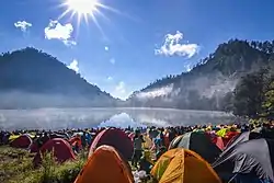
- Ranu Pane, Ranu Regulo, Ranu Kumbolo—crater lakes at the slope of Mount Semeru
- Mount Semeru
- Tetes Cave
- Mandara Giri Temple
- Piket Nol (highway place where we can see Cold Lava from Semeru)
- Tumpak Sewu Waterfalls
References
- Badan Pusat Statistik, Jakarta, 2023, Kabupaten Lumajang Dalam Angka 2023 (Katalog-BPS 1102001.3508)
- Biro Pusat Statistik, Jakarta, 2011.
- Badan Pusat Statistik, Jakarta, 2021.
- "A Brief History of Lumajang". lumajang.in. Archived from the original on 2 April 2015. Retrieved 1 October 2008.
- "Climate: Lumajang". Climate-Data.org. Retrieved 15 November 2020.
External links
- (in Indonesian) Official website
- Tourism site
