East Luwu Regency
East Luwu Regency is the most easterly of the twenty-one regencies in South Sulawesi Province of Indonesia. The regency was created on 25 February 2003 by separation of the eastern districts from North Luwu Regency (itself only split off from Luwu Regency on 20 April 1999). It covers an area of 6,944.88 km2. The administrative capital of the regency is the coastal town of Malili on the Bay of Usu, itself an inlet in the northeast corner of the Gulf of Bone; the town, with its port of Balantang, is the shipping port for one of the world's major nickel-producing plants. The population of the Regency was 243,069 at the 2010 Census[2] and 296,741 at the 2020 Census;[3] the official estimate as at mid 2022 was 305,521 (comprising 157,221 males and 148,300 females).[1]
East Luwu Regency
Kabupaten Luwu Timur | |
|---|---|
|
Coat of arms | |
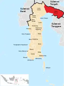 Location within South Sulawesi | |
| Country | Indonesia |
| Province | South Sulawesi |
| Capital | Malili |
| Government | |
| • Regent | Budiman Hakim |
| • Vice Regent | Akbar Andi Leluasa |
| Area | |
| • Total | 6,944.98 km2 (2,681.47 sq mi) |
| Population (mid 2022 estimate)[1] | |
| • Total | 305,521 |
| • Density | 44/km2 (110/sq mi) |
| Time zone | UTC+8 (WITA) |
| Area code | +62 474 & 475 |
Malili Lakes
The eastern part of the regency contains the large natural fresh-water lakes of Lake Towuti (Danau Towuti) covering an area of 561 km2 in the south-east and Lake Matana (Danau Matana) covering 164 km2 further north, as well as the smaller Danau Mahalona between them. These (with the even smaller Danau Masapi and Danau Lontoa) form the Malili Lake system. Danau Towuti, which is 48 km wide, is the largest lake on Sulawesi, and contains the island of Pulau Luha within it. Danau Matana is the deepest lake in Indonesia (and the deepest lake on an island in the world), reaching a depth of 590 metres.
On the south shore of Lake Matana is the town of Soroako, the centre for the nickel processing plant, and its massive mine complex. Soroako, with its satellite villages of Wasuponda and Wawandula, are connected by a modern highway to the sea at Malili.
Administration
East Luwu Regency is divided into eleven administrative Districts (Kecamatan), tabulated below with their areas and their populations at the 2010 Census[2] and the 2020 Census,[3] together with the official estimates as of mid 2022.[1] The table also includes the locations of the district administrative centres, the numbers of administrative villages in each district (totalling 125 rural desa and 3 urban kelurahan), and its post codes.
| Name of District (kecamatan) | Area in km2 | Pop'n Census 2010 | Pop'n Census 2020 | Pop'n estimate mid 2022 | Admin centre | No. of villages | Post code |
|---|---|---|---|---|---|---|---|
| Burau | 256.23 | 30,875 | 34,214 | 34,529 | Burau | 18 | 92975 |
| Wotu | 130.52 | 28,100 | 33,345 | 34,101 | Bawalipu | 17 | 92971 |
| Tomoni | 230.09 | 22,333 | 26,406 | 26,986 | Mandiri | 13 (a) | 92972 |
| Tomoni Timur (East Tomoni) | 43.91 | 11,738 | 13,741 | 13,602 | Kertoraharjo | 8 | 92970 |
| Angkona | 147.24 | 21,681 | 25,075 | 25,516 | Solo | 10 | 92985 |
| Malili | 921.20 | 32,699 | 42,826 | 44,641 | Puncak Indah | 14 (b) | 92981 |
| Towuti | 1,820.48 | 27,200 | 42,087 | 45,310 | Langkea Raya | 19 | 92982 |
| Nuha | 808.27 | 20,087 | 23,399 | 23,844 | Sorowako | 5 (c) | 92983 |
| Wasuponda | 1,244.00 | 17,969 | 21,610 | 22,157 | Ledu-Ledu | 6 | 92984 |
| Mangkutana | 1,300.96 | 19,839 | 22,232 | 22,485 | Wonorejo | 11 | 92974 |
| Kalaena | 41.98 | 10,548 | 12,032 | 12,211 | Kalaena Kiri | 7 | 92973 |
| Totals | 6,944.88 | 243,069 | 296,741 | 305,521 | Malili | 128 |
Notes: (a) including the kelurahan of Tomoni. (b) including the kelurahan of Malili. (c) including the kelurahan of Magani.
Climate
Kanowit has a tropical rainforest climate (Af) with heavy rainfall year-round.
| Climate data for Malili | |||||||||||||
|---|---|---|---|---|---|---|---|---|---|---|---|---|---|
| Month | Jan | Feb | Mar | Apr | May | Jun | Jul | Aug | Sep | Oct | Nov | Dec | Year |
| Average high °C (°F) | 29.9 (85.8) |
29.8 (85.6) |
30.0 (86.0) |
30.1 (86.2) |
29.8 (85.6) |
29.0 (84.2) |
28.6 (83.5) |
29.5 (85.1) |
30.2 (86.4) |
31.2 (88.2) |
30.9 (87.6) |
30.3 (86.5) |
29.9 (85.9) |
| Daily mean °C (°F) | 26.0 (78.8) |
25.9 (78.6) |
26.1 (79.0) |
26.2 (79.2) |
26.1 (79.0) |
25.4 (77.7) |
24.8 (76.6) |
25.3 (77.5) |
25.7 (78.3) |
26.4 (79.5) |
26.5 (79.7) |
26.3 (79.3) |
25.9 (78.6) |
| Average low °C (°F) | 22.1 (71.8) |
22.1 (71.8) |
22.2 (72.0) |
22.3 (72.1) |
22.5 (72.5) |
21.9 (71.4) |
21.1 (70.0) |
21.2 (70.2) |
21.2 (70.2) |
21.7 (71.1) |
22.2 (72.0) |
22.3 (72.1) |
21.9 (71.4) |
| Average rainfall mm (inches) | 230 (9.1) |
226 (8.9) |
288 (11.3) |
319 (12.6) |
279 (11.0) |
220 (8.7) |
176 (6.9) |
141 (5.6) |
126 (5.0) |
109 (4.3) |
171 (6.7) |
208 (8.2) |
2,493 (98.3) |
| Source: Climate-Data.org[4] | |||||||||||||
References
- Badan Pusat Statistik, Jakarta, 2023, Kabupaten Luwu Timur Dalam Angka 2023 (Katalog-BPS 1102001.7324)
- Biro Pusat Statistik, Jakarta, 2011.
- Badan Pusat Statistik, Jakarta, 2021.
- "Climate: Malili". Climate-Data.org. Retrieved 19 November 2020.
External links
Regencies and cities of South Sulawesi | ||
|---|---|---|
Capital: Makassar | ||
| Regencies |  | |
| Cities | ||