M6 motorway (Hungary)
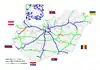
The M6 motorway (Hungarian: M6-os autópálya) is a north-south motorway in Hungary running along the Danube connecting Budapest to the seat of Baranya county Pécs, and further south to the Croatian border.
_Otszogletu_kek_tabla.svg.png.webp) | |
|---|---|
| M6-os autópálya | |
 | |
| Route information | |
| Part of | |
| Length | 193 km (120 mi) 212 km (132 mi) planned |
| Major junctions | |
| From | |
| To | Ivándárda |
| Location | |
| Country | Hungary |
| Counties | Pest, Fejér, Tolna, Baranya |
| Major cities | Budapest, Érd, Dunaújváros, Paks, Szekszárd, Mohács |
| Highway system | |
| |
The southernmost Bóly - Ivándárda (border crossing with Croatia) section is currently under construction with a planned inauguration date in 2024.[1] The connecting segment of the A5 in Croatia is also under construction, with the completion scheduled for 2023.[2]
Municipalities
The M6 motorway runs through the following municipalities:
- Budapest, Érd, Százhalombatta
- Ercsi, Ráckeresztúr, Besnyő, Beloiannisz, Iváncsa, Adony, Kulcs, Rácalmás, Dunaújváros, Baracs, Daruszentmiklós, Előszállás
- Dunaföldvár, Bölcske, Paks, Dunaszentgyörgy, Fadd, Tengelic, Tolna, Fácánkert, Szedres, Szekszárd, Őcsény, Decs, Sárpilis, Várdomb, Alsónyék, Bátaszék
- Véménd, Palotabozsok, Szebény, Szűr, Himesháza, Székelyszabar, Kisnyárád, Lánycsók, Babarc
Openings timeline
- Budapest; M0 – Érdi-tető (7 km): 2008.09.23.
- Érdi-tető – Dunaújváros; M8 (68 km): 2006.06.11.
- Dunaújváros; M8 – Bóly; M60 (118 km): 2010.03.31.
Junctions, exits and rest areas
- Distance from Zero Kilometre Stone (Adam Clark Square) in Budapest in kilometres.
| M0 (Budapest) – Ivándárda (212 km) | ||||
| 15 km | Győr, Nagykanizsa / Szeged, Nyíregyháza Budapest International Airport | Budapest bypass | ||
| 18 km | Érd east / Budapest-Nagytétény | |||
| 20 km | Érd-Ófalu | |||
| 22 km | Érdi-tető | |||
| 25 km | Százhalombatta north | |||
| 29 km | Százhalombatta south | |||
| 31 km | Keresztúri rest area | |||
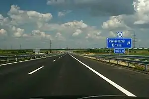
| 34 km | Ráckeresztúr, Martonvásár / Ercsi | 6204 | ||
| 40 km | Fácános rest area | |||
| 45 km | Besenyő, Pusztaszabolcs / Beloiannisz | 6205 | ||
| 50 km | Iváncsa / Pusztaszabolcs, Velence | 6207 | ||
| 55 km | Adony / Perkáta | 6208 | ||
| 57 km | Szentmihályi rest area | |||
| 62 km | Kulcs, Rácalmás | |||
| 67 km | Dunaújváros north / Székesfehérvár | |||
| 70 km | Dunaújváros / Mezőfalva, Sárbogárd | 6219 | ||
| 71 km | Újvárosi rest area | |||
| 75 km | Dunaújváros south, Szolnok / Szentgotthárd | M8 | ||
| 83 km | Dunaföldvár north / Daruszentmiklós, Seregélyes | 6228 | ||
| 87 km | Dunaföldvár, Solt / Előszállás, Nagykanizsa | |||
| 92 km | Dunaföldvári rest area | |||
| 98 km | Dunaföldvár south, Paks north (Gabonásvölgy junction) | |||
| Gyűrűs-árok | ||||
| Vörösmalmi-árok | ||||
| 106 km | Paks / Németkér, Cece | 6231 | ||
| 108 km | Paksi rest area | |||
| 114 km | Paks south | 6232 | ||
| 120 km | Szentgyörgyi rest area | |||
| 124 km | Tengelic / Dunaszentgyörgy, Fadd | 6234 | ||
| 131 km | Szedres | 631 | ||
| 134 km | Fácánkerti rest area | |||
| 138 km | Tolna | |||
| 142 km | Szombathely, Nagykanizsa, Kaposvár / Szeged | M9 turns toward -> Szombathely or Szeged | ||
| Sió River | ||||
| 147 km | Szekszárd Centrum | 5113 | ||
| 151 km | Szekszárd south / Őcsény | 5114 | ||
| 155 km | Szentgyörgyi rest area | |||
| 164 km | Bonyhád / Bátaszék, Baja | |||
| 165 km | Geresdi rest area | |||
| 167-68 km | Bátaszék Tunnel "A" | Tunnel - 1331 m | ||
| 169 km | Belső-réti patak Viaduct | Bridge - 280 m | ||
| 169 km | Geresd Tunnel "B" | Tunnel - 399 m | ||
| 170 km | Belső-réti patak Viaduct | Bridge - 313 m | ||
| 170-71 km | Baranya Tunnel "C" | Tunnel - 865 m | ||
| 172 km | Véménd Tunnel "D" | Tunnel - 418 m | ||
| 173 km | Palotabozsoki-vízfolyás Viaduct | Bridge - 481 m | ||
| Véménd, Pécsvárad / Palotabozsok, Somberek | 5606 | |||
| Szebény Viaduct | Bridge - 830 m | |||
| 181 km | Szebényi rest area | |||
| Csele patak Viaduct | Bridge - 450 m | |||
| Himesházai-árok Viaduct | Bridge - 491 m | |||
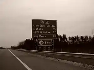
| 191 km | Lánycsók, Mohács / Babarc | |||
| 193 km | Pécs, Barcs | M60 turns toward -> | ||
| Signs | Distance | Destinations | Note |
|---|---|---|---|
| (196 km) | Nagynyárád, Bóly - East | ||
| (210 km) | Ivándárda, Kislippó | ||
| Ivándárda / Branjin Vrh border crossing | |||
| Osijek, |
Toll
From February 1, 2015, the M6 motorway is fully charged. The motorway can be used instead of the national sticker with the following county stickers:
| Type of vignette | Available section |
|---|---|
| Pest County | between M0 expressway junction and Ráckeresztúr (15 km – 34 km) |
| Fejér County | between Százhalombatta north and Paks north (25 km – 98 km) |
| Tolna County | between M8 motorway junction and Pécsvárad (Somberek) (75 km – 173 km) |
| Baranya County | between Bátaszék and Bóly west (163 km – 191 km) |
Significant artifacts
From Budapest to the Croatian border, the M6 motorway features the following bridges, tunnels or covered cuts:
- Viaducts
- Belső-réti patak Viaduct (Belső-réti patak völgyhíd I.; 280 m or 920 ft)
- Belső-réti patak Viaduct (Belső-réti patak völgyhíd II.; 313 m or 1,027 ft)
- Palotabozsoki-vízfolyás Viaduct (Palotabozsoki-vízfolyás völgyhíd; 481 m or 1,578 ft)
- Szebény Viaduct (Szebényi völgyhíd; 830 m or 2,720 ft)
- Csele patak Viaduct (Csele-patak völgyhíd; 450 m or 1,480 ft)
- Himesházai árok Viaduct (Himesházai árok völgyhíd; 491 m or 1,611 ft)
- Tunnels
- Bátaszék Tunnel (Bátaszék alagút "A"; 1,331 m or 4,367 ft) – Longest tunnel in Hungary
- Geresd Tunnel (Geresd alagút "B"; 399 m or 1,309 ft)
- Baranya Tunnel (Baranya alagút "C"; 865 m or 2,838 ft)
- Véménd Tunnel (Véménd alagút "D"; 418 m or 1,371 ft)
European Route
| Name | Route | |
| 197 km | ||
References
- "Construction of the final section of M6 Motorway has begun (in Hungarian)". Retrieved 26 March 2022.
- "A5 Brochure 2018" (PDF). Retrieved 29 January 2019.
External links
- National Toll Payment Services Plc. (in Hungarian, some information also in English)
- National Infrastructure Developer Ltd. (in Hungarian)
- Exit list of M6 in motorways-exits.com
- Construction works of the new section