Minnesota's 3rd congressional district
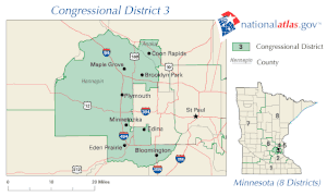
Minnesota's 3rd congressional district encompasses the suburbs of Hennepin and Anoka counties to the west, south, and north of Minneapolis. The district, which is mostly suburban in character, includes a few farming communities on its far western edge and also inner-ring suburban areas on its eastern edge. The district includes the blue collar cities of Brooklyn Park and Coon Rapids to the north-east, middle-income Bloomington to the south, and higher-income Eden Prairie, Edina, Maple Grove, Plymouth, Minnetonka, and Wayzata to the west. Democrat Dean Phillips currently represents the district in the U.S. House of Representatives, after defeating incumbent Republican Erik Paulsen in the 2018 midterm elections.
| Minnesota's 3rd congressional district | |||
|---|---|---|---|
Interactive map of district boundaries since January 3, 2023, with Hennepin County highlighted in red | |||
| Representative |
| ||
| Area | 468[1] sq mi (1,210 km2) | ||
| Distribution |
| ||
| Population (2022) | 700,754[3] | ||
| Median household income | $100,867[4] | ||
| Ethnicity |
| ||
| Cook PVI | D+8[5] | ||
| External image | |
|---|---|
Recent statewide election results
| Year | Office | Results | Party |
|---|---|---|---|
| 2000 | President | Bush 50 - 46% | Republican |
| 2004 | President | Bush 51 - 48% | Republican |
| 2008 | President | Obama 52 - 46% | Democratic |
| 2012 | President | Obama 49.6 - 48.8% | Democratic |
| 2016 | President | Clinton 50.8 - 41.4% | Democratic |
| 2018 | Senate | Klobuchar 62.3 - 34.7% | Democratic |
| 2020 | President | Biden 58.7 - 39.2% | Democratic |
| 2022 | Governor | Tim Walz 59.2 - 38.13%[6] | Democratic
|
List of members representing the district
Recent election results
Graph of election results in Minnesota's 3rd congressional district
2022
| Party | Candidate | Votes | % | |
|---|---|---|---|---|
| Democratic (DFL) | Dean Phillips (Incumbent) | 198,883[6] | 59.56% | |
| Republican | Tom Weiler | 134,797[6] | 40.37% | |
2020
| Party | Candidate | Votes | % | |
|---|---|---|---|---|
| Democratic (DFL) | Dean Phillips (Incumbent) | 246,666 | 55.61% | |
| Republican | Kendall Qualls | 196,625 | 44.32% | |
2018
| Party | Candidate | Votes | % | |
|---|---|---|---|---|
| Democratic (DFL) | Dean Phillips | 202,402 | 55.61% | |
| Republican | Erik Paulsen (Incumbent) | 160,838 | 44.19% | |
2016
| Party | Candidate | Votes | % | |
|---|---|---|---|---|
| Republican | Erik Paulsen (Incumbent) | 233,075 | 56.9% | |
| Democratic (DFL) | Terri Bonoff | 169,238 | 43.1% | |
2014
| Party | Candidate | Votes | % | |
|---|---|---|---|---|
| Republican | Erik Paulsen (Incumbent) | 167,515 | 62.1 | |
| Democratic (DFL) | Sharon Sund | 101,846 | 37.8 | |
2012
| Party | Candidate | Votes | % | |
|---|---|---|---|---|
| Republican | Erik Paulsen (Incumbent) | 222,335 | 58.10 | |
| Democratic (DFL) | Brian Barnes | 159,937 | 41.79 | |
| Write-in | 433 | 0.11 | ||
| Total votes | 382,705 | 100.0 | ||
2010
| Party | Candidate | Votes | % | |
|---|---|---|---|---|
| Republican | Erik Paulsen (Incumbent) | 161,177 | 58.8 | |
| Democratic (DFL) | Jim Meffert | 100,240 | 36.6 | |
| Independence | Jon Oleson | 12,508 | 4.6 | |
2008
| Party | Candidate | Votes | % | |
|---|---|---|---|---|
| Republican | Erik Paulsen (Incumbent) | 179,032 | 48.5 | |
| Democratic (DFL) | Ashwin Madia | 150,863 | 40.9 | |
| Independence | David Dillon | 38,987 | 10.6 | |
2006
| Party | Candidate | Votes | % | |
|---|---|---|---|---|
| Republican | Jim Ramstad (Incumbent) | 184,355 | 64.9 | |
| Democratic (DFL) | Wendy Wilde | 99,599 | 35.0 | |
2004
| Party | Candidate | Votes | % | |
|---|---|---|---|---|
| Republican | Jim Ramstad (Incumbent) | 231,871 | 64.7 | |
| Democratic (DFL) | Deborah Watts | 126,665 | 35.3 | |
2002
| Party | Candidate | Votes | % | |
|---|---|---|---|---|
| Republican | Jim Ramstad (Incumbent) | 213,334 | 72.0 | |
| Democratic (DFL) | Darryl Stanton | 82,575 | 27.9 | |
2000
| Party | Candidate | Votes | % | |
|---|---|---|---|---|
| Republican | Jim Ramstad (Incumbent) | 222,571 | 67.6 | |
| Democratic (DFL) | Sue Schuff | 98,219 | 29.9 | |
| Libertarian | Bob Odden | 5,302 | 1.6 | |
| Constitution | Arne Niska | 2,970 | 0.9 | |
Historical district boundaries
2003–2013
.tif.png.webp)
2013–2023
References
- "Minnesota congressional districts by urban and rural population and land area" (PDF). US Census Bureau. 2000. Retrieved April 2, 2007.
- Geography, US Census Bureau. "Congressional Districts Relationship Files (state-based)". www.census.gov. Retrieved April 7, 2018.
- Bureau, Center for New Media & Promotion (CNMP), US Census. "My Congressional District". www.census.gov. Retrieved October 5, 2023.
{{cite web}}: CS1 maint: multiple names: authors list (link) - "My Congressional District".
- "2022 Cook PVI: District Map and List". Cook Political Report. Retrieved January 10, 2023.
- https://electionresults.sos.state.mn.us/results/Index?ErsElectionId=149&scenario=StateFedCongressional&DistrictId=558&show=Go
This article is issued from Wikipedia. The text is licensed under Creative Commons - Attribution - Sharealike. Additional terms may apply for the media files.
.svg.png.webp)


.jpg.webp)



.jpg.webp)


.jpg.webp)
.tif.png.webp)
