Magama, Nigeria
Magama is a Local Government Area in Niger State, Nigeria. Its headquarters are in the town of Nasko in the west of the area.
Magama | |
|---|---|
 Magama Location in Nigeria | |
| Coordinates: 10°28′N 5°03′E | |
| Country | |
| State | Niger State |
| Government | |
| • Local Government Chairman and the Head of the Local Government Council | Idris Aliyu Babangida |
| Area | |
| • Total | 4,107 km2 (1,586 sq mi) |
| Population (2006 census) | |
| • Total | 181,653 |
| Time zone | UTC+1 (WAT) |
| 3-digit postal code prefix | 923 |
| ISO 3166 code | NG.NI.MM |
It has an area of 4,107 km2 and a population of 181,653 at the 2006 census.
The postal code of the area is 923.[1]
Climate
The weather in Magama is savanna tropical. With both a wet and dry season, it is warm every month. There is roughly 507 mm of rain every year in Magama, and the average annual temperature is 35 degrees. Averaging 55% humidity and a UV-index of 7, it is dry for 186 days out of every year.[2][3][4]
References
- "Post Offices- with map of LGA". NIPOST. Archived from the original on 2012-11-26. Retrieved 2009-10-20.
- "Magama weather and climate ☀️ Best time to visit 🌡️ Temperature". www.besttimetovisit.co.nz. Retrieved 2023-09-27.
- "Magama weather forecast for today". justweather.org. Retrieved 2023-09-27.
- "Magama, Niger, Nigeria Weather Forecast and Conditions - The Weather Channel | Weather.com". The Weather Channel. Retrieved 2023-09-27.
State capital: Minna | ||
| Local Government Areas | 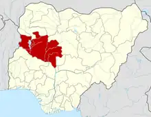 | |
This article is issued from Wikipedia. The text is licensed under Creative Commons - Attribution - Sharealike. Additional terms may apply for the media files.