Malayer
Malayer (Persian: ملایر, romanized: Malāyer), formerly Dowlatabad (Persian: دولتآباد, romanized: Doulatābād, also Romanized as Dowlatābād and Daūlatābād),[3] is a city in the Central District of Malayer County, Hamadan province, Iran, serving as both capital of the district and of the county.
Malayer
Persian: ملایر | |
|---|---|
City | |
 Malayer | |
| Coordinates: 34°18′00″N 48°49′04″E[1] | |
| Country | |
| Province | Hamadan |
| County | Malayer |
| District | Central |
| Population (2016)[2] | |
| • Total | 170,237 |
| Time zone | UTC+3:30 (IRST) |
At the 2006 National Census, its population was 153,748 in 40,750 households.[4] The following census in 2011 counted 159,848 people in 46,939 households.[5] The latest census in 2016 showed a population of 170,237 people in 52,697 households.[2]
The second largest city of the province, Malayer has a reputation for rug-weaving and has some popular parks. The biggest historical park is Seifiyeh. Malayer is located between Hamadan and Borujerd in Lorestan province.[6] This city is one of main centers of furniture industry in Iran.[7]
Language
Linguistic composition of the city consists of Luri & Luri dialects as the majority indigenous tongue spoken at about 80% and standard Persian at 20%.[8]
Climate
| Climate data for Malayer (Elevation:1777.8m)(1992-2010) | |||||||||||||
|---|---|---|---|---|---|---|---|---|---|---|---|---|---|
| Month | Jan | Feb | Mar | Apr | May | Jun | Jul | Aug | Sep | Oct | Nov | Dec | Year |
| Average high °C (°F) | 5.4 (41.7) |
7.9 (46.2) |
12.3 (54.1) |
18.3 (64.9) |
23.7 (74.7) |
30.6 (87.1) |
34.7 (94.5) |
34.6 (94.3) |
29.8 (85.6) |
22.8 (73.0) |
14.1 (57.4) |
8.9 (48.0) |
20.3 (68.5) |
| Daily mean °C (°F) | 0.4 (32.7) |
2.9 (37.2) |
7.1 (44.8) |
12.0 (53.6) |
16.5 (61.7) |
21.8 (71.2) |
25.7 (78.3) |
25.2 (77.4) |
20.5 (68.9) |
15.1 (59.2) |
8.1 (46.6) |
3.6 (38.5) |
13.2 (55.8) |
| Average low °C (°F) | −4.1 (24.6) |
−2.7 (27.1) |
0.5 (32.9) |
5.6 (42.1) |
8.9 (48.0) |
12.5 (54.5) |
16.4 (61.5) |
16.0 (60.8) |
11.0 (51.8) |
7.1 (44.8) |
2.3 (36.1) |
−1.2 (29.8) |
6.0 (42.8) |
| Average precipitation mm (inches) | 33.2 (1.31) |
40.6 (1.60) |
59.2 (2.33) |
55.4 (2.18) |
24.6 (0.97) |
3.4 (0.13) |
1.7 (0.07) |
3.8 (0.15) |
1.4 (0.06) |
15.6 (0.61) |
45.4 (1.79) |
35.3 (1.39) |
319.6 (12.59) |
| Average relative humidity (%) | 69 | 62 | 56 | 51 | 44 | 30 | 27 | 26 | 27 | 38 | 58 | 65 | 46 |
| Source: IRIMO[9] | |||||||||||||
Notable people
- Ahad Azadikhah, Cleric
- Mohammad Mohammadi-Malayeri, Iranian historian, linguist, and literary scholar
- Mojtaba Zonnour, Cleric
- Enshaallah Rahmati, Iranian philosopher, thinker and translator
Gallery

 Malayer Museum.
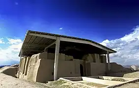 Nooshijan
 Kosar park of Malayer
 Replica of the Pisa tower in Malayer
 Railroad station
References
- OpenStreetMap contributors (18 October 2023). "Malayer, Malayer County" (Map). OpenStreetMap. Retrieved 18 October 2023.
- "Census of the Islamic Republic of Iran, 1395 (2016)". AMAR (in Persian). The Statistical Center of Iran. p. 13. Archived from the original (Excel) on 21 April 2021. Retrieved 19 December 2022.
- Malayer can be found at GEOnet Names Server, at this link, by opening the Advanced Search box, entering "-3073682" in the "Unique Feature Id" form, and clicking on "Search Database".
- "Census of the Islamic Republic of Iran, 1385 (2006)". AMAR (in Persian). The Statistical Center of Iran. p. 13. Archived from the original (Excel) on 20 September 2011. Retrieved 25 September 2022.
- "Census of the Islamic Republic of Iran, 1390 (2011)" (Excel). Iran Data Portal (in Persian). The Statistical Center of Iran. p. 13. Retrieved 19 December 2022.
- ""Mini World" theme park; Malayer tourist gate from Persepolis to Eiffel". IRNA English. 7 July 2020. Retrieved 26 April 2021.
- https://malayeru.ac.ir/en/portal/home/?report/117252/117406/117407/introduction-to-malayer-advanced-furniture-and-wood-carving-research-center], Malayer University
- "Atlas of the Languages of Iran".
- Archived February 17, 2016, at the Wayback Machine
External links
Hamadan Province, Iran | |||||||||||||||||||||
|---|---|---|---|---|---|---|---|---|---|---|---|---|---|---|---|---|---|---|---|---|---|
| Capital |  | ||||||||||||||||||||
| Counties and cities |
| ||||||||||||||||||||
| Sights |
| ||||||||||||||||||||
| populated places | |||||||||||||||||||||