Markopoulo Oropou
Markopoulo Oropou (Greek: Μαρκόπουλο Ωρωπού) is a town and a former community of East Attica, Greece. Since the 2011 local government reform it is part of the municipality Oropos, of which it is a municipal unit.[2] The municipal unit has an area of 23.177 km2.[3]
Markopoulo Oropou
Μαρκόπουλο Ωρωπού | |
|---|---|
 Markopoulo Oropou Location within the regional unit 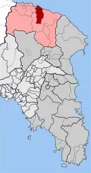 | |
| Coordinates: 38°17′N 23°49′E | |
| Country | Greece |
| Administrative region | Attica |
| Regional unit | East Attica |
| Municipality | Oropos |
| • Municipal unit | 23.177 km2 (8.949 sq mi) |
| Elevation | 94 m (308 ft) |
| Population (2011)[1] | |
| • Municipal unit | 2,798 |
| • Municipal unit density | 120/km2 (310/sq mi) |
| Time zone | UTC+2 (EET) |
| • Summer (DST) | UTC+3 (EEST) |
| Postal code | 190 15 |
| Area code(s) | 22950 |
| Vehicle registration | Z |
Markopoulo Oropou is situated 3 km south of the South Euboean Gulf coast. It is 4 km southeast of Nea Palatia and 35 km north of Athens city center. The municipal unit Markopoulo Oropou consists of the town Markopoulo and the villages Neo Livyssi, Agia Varvara and Bafi.
Historical population
| Year | Town population | Community population |
|---|---|---|
| 1981 | - | 2,006 |
| 1991 | 877 | 2,208 |
| 2001 | 3,532 | 3,894 |
| 2011 | 2,549 | 2,798 |
The village has historically been an Arvanite settlement.[4]
References
- "Απογραφή Πληθυσμού - Κατοικιών 2011. ΜΟΝΙΜΟΣ Πληθυσμός" (in Greek). Hellenic Statistical Authority.
- "ΦΕΚ B 1292/2010, Kallikratis reform municipalities" (in Greek). Government Gazette.
- "Population & housing census 2001 (incl. area and average elevation)" (PDF) (in Greek). National Statistical Service of Greece. Archived from the original (PDF) on 2015-09-21.
- Pantelidis, Nikos; Liosis, Nikos (2019). "Dialectical Modern Greek Influences on Arvanitika". Modern Greek Dialects and Linguistics Theory. National and Kapodistrian University of Athens: 224.
External links
Places adjacent to Markopoulo Oropou | ||||||||||||||||
|---|---|---|---|---|---|---|---|---|---|---|---|---|---|---|---|---|
| ||||||||||||||||
This article is issued from Wikipedia. The text is licensed under Creative Commons - Attribution - Sharealike. Additional terms may apply for the media files.