Polydendri
Polydendri (Greek: Πολυδένδρι, English: "Many trees") is a town and former community of East Attica, Greece. Since the 2011 local government reform it is part of the municipality Oropos, of which it is a municipal unit.[2] It is part of Athens metropolitan area.[3] Polydendri has historically been an Arvanite settlement.[4]
Polydendri
Πολυδένδρι | |
|---|---|
 Polydendri Location within the regional unit 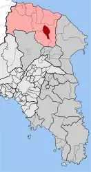 | |
| Coordinates: 38°12′N 23°52′E | |
| Country | Greece |
| Administrative region | Attica |
| Regional unit | East Attica |
| Municipality | Oropos |
| • Municipal unit | 13.881 km2 (5.359 sq mi) |
| Elevation | 333 m (1,093 ft) |
| Population (2011)[1] | |
| • Municipal unit | 1,608 |
| • Municipal unit density | 120/km2 (300/sq mi) |
| Time zone | UTC+2 (EET) |
| • Summer (DST) | UTC+3 (EEST) |
Geography
It is located north of Athens. Polydendri is at an altitude of 340 meters. The town contains no more than 1,385 residents (2011 census) and it has many cultural unions, such as a youth union, a traditional dance union, an athletic club (the "Black Eagle of Polydendri" playing at the athletic center of Gourezi), a tracking club and a heavy metal society (called "the Obscure" and numbering 1.500 members from all around Greece). Furthermore, Polydendri is known for its taverns.
The postal code of Polydendri is 19014 and its telephone access code is +3022950.[5] The municipal unit has a land area of 13.881 km2[6] and also includes the villages of Taxiárches (pop. 116), Irakleideís (68), and Ágios Geórgios (39). Its total population was 1,608 at the 2011 census.[1]
References
- "Απογραφή Πληθυσμού - Κατοικιών 2011. ΜΟΝΙΜΟΣ Πληθυσμός" (in Greek). Hellenic Statistical Authority.
- "ΦΕΚ B 1292/2010, Kallikratis reform municipalities" (in Greek). Government Gazette.
- "Athens Population 2022 (Demographics, Maps, Graphs)".
- Hans-Jürgen Sasse (1991). Arvanitika: die albanischen Sprachreste in Griechenland. Vol. 1. p. 18. ISBN 9783447027588.
- "Polydendri Athens | Polydendri Information | Polydendri Weather | Polydendri Map | Greece.com". www.greece.com. Retrieved 2020-02-06.
- "Population & housing census 2001 (incl. area and average elevation)" (PDF) (in Greek). National Statistical Service of Greece.
Places adjacent to Polydendri | ||||||||||||||||
|---|---|---|---|---|---|---|---|---|---|---|---|---|---|---|---|---|
| ||||||||||||||||