Marlboro (CDP), New Jersey
Marlboro is a census-designated place (CDP)[5] located in Stow Creek Township on the northwestern edge of Cumberland County, in the U.S. state of New Jersey. It is bordered to the northwest, across Sarah Run, by Quinton Township in Salem County. The CDP contains the unincorporated communities of Marlboro and Campbells Corner.
Marlboro, New Jersey | |
|---|---|
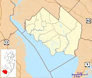 Marlboro CDP Location in Cumberland County  Marlboro CDP Location in New Jersey  Marlboro CDP Location in the United States | |
| Coordinates: 39°29′8″N 75°19′11″W | |
| Country | |
| State | |
| County | Cumberland |
| Township | Stow Creek |
| Area | |
| • Total | 0.39 sq mi (1.00 km2) |
| • Land | 0.39 sq mi (1.00 km2) |
| • Water | 0.00 sq mi (0.00 km2) |
| Elevation | 117 ft (36 m) |
| Population | |
| • Total | 127 |
| • Density | 329.87/sq mi (127.20/km2) |
| Time zone | UTC−05:00 (Eastern (EST)) |
| • Summer (DST) | UTC−04:00 (EDT) |
| ZIP Code | 08302 (Bridgeton) |
| Area code | 856 |
| FIPS code | 34-44010[3] |
| GNIS feature ID | 2806123[4] |
New Jersey Route 49 passes through the CDP, leading southeast 6 miles (10 km) to Bridgeton, the Cumberland county seat, and northwest 10 miles (16 km) to Salem.
Marlboro was first listed as a CDP prior to the 2020 census.[4]
Demographics
As of the 2020 United States census, the population was 127.[2]
| Census | Pop. | Note | %± |
|---|---|---|---|
| 2020 | 127 | — | |
| U.S. Decennial Census[6] 2020[2] | |||
References
- "ArcGIS REST Services Directory". United States Census Bureau. Retrieved October 11, 2022.
- Census Data Explorer: Marlboro CDP, New Jersey, United States Census Bureau. Accessed June 15, 2023.
- Geographic Codes Lookup for New Jersey, Missouri Census Data Center. Accessed June 9, 2023.
- "Marlboro Census Designated Place". Geographic Names Information System. United States Geological Survey, United States Department of the Interior.
- State of New Jersey Census Designated Places - BVP20 - Data as of January 1, 2020, United States Census Bureau. Accessed December 1, 2022.
- "Census of Population and Housing". Census.gov. Retrieved June 4, 2016.
Municipalities and communities of Cumberland County, New Jersey, United States | ||
|---|---|---|
| Cities | 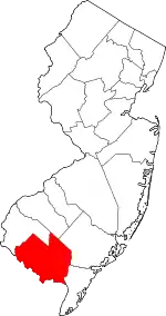 Map of New Jersey highlighting Cumberland County | |
| Borough | ||
| Townships | ||
| CDPs |
| |
| Other communities | ||
| Footnotes | ‡This populated place also has portions in an adjacent county or counties | |
This article is issued from Wikipedia. The text is licensed under Creative Commons - Attribution - Sharealike. Additional terms may apply for the media files.