Mianeh County (Iran)
Mianeh County[3] (also Miyaneh County) (Persian: شهرستان میانه) is in East Azerbaijan province, Iran.[4] Its capital is the city of Mianeh.
Mianeh County
Persian: شهرستان میانه | |
|---|---|
County | |
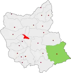 Location of Mianeh County in East Azerbaijan province | |
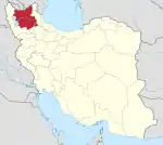
 Location of East Azerbaijan province in Iran | |
| Coordinates: 37°29′N 47°48′E[1] | |
| Country | |
| Province | East Azerbaijan |
| Capital | Mianeh |
| Districts | Central, Kaghazkonan, Kandovan, Torkamanchay |
| Population (2016)[2] | |
| • Total | 182,848 |
| Time zone | UTC+3:30 (IRST) |
| Mianeh County (Iran) can be found at GEOnet Names Server, at this link, by opening the Advanced Search box, entering "9205880" in the "Unique Feature Id" form, and clicking on "Search Database". | |
At the 2006 census, the county's population was 187,870 in 46,469 households.[5] The following census in 2011 counted 185,806 people in 52,630 households.[6] At the 2016 census, the county's population was 182,848 in 57,665 households.[2] The city of Torkamanchay is where the Treaty of Turkmenchay was signed by Russia and Iran in 1828.
Administrative divisions
The population history and structural changes of Mianeh County's administrative divisions over three consecutive censuses are shown in the following table. The latest census shows four districts, 17 rural districts, and five cities.[2]
| Administrative Divisions | 2006[5] | 2011[6] | 2016[2] |
|---|---|---|---|
| Central District | 126,668 | 130,079 | 129,600 |
| Garmeh-ye Jonubi RD | 8,205 | 6,331 | 5,394 |
| Kolah Boz-e Gharbi RD | 5,121 | 4,107 | 3,553 |
| Kolah Boz-e Sharqi RD | 5,825 | 5,209 | 4,402 |
| Owch Tappeh-ye Sharqi RD | 2,636 | 2,026 | 1,843 |
| Qaflankuh-e Gharbi RD | 12,166 | 11,920 | 7,372 |
| Qezel Uzan RD | 2,958 | 2,673 | 2,617 |
| Sheykhdarabad RD | 2,372 | 2,308 | 1,799 |
| Achachi (city) | 3,647 | ||
| Mianeh (city) | 87,385 | 95,505 | 98,973 |
| Kaghazkonan District | 11,101 | 9,366 | 10,729 |
| Kaghazkonan-e Markazi RD | 2,186 | 1,930 | 2,038 |
| Kaghazkonan-e Shomali RD | 3,818 | 2,959 | 3,216 |
| Qaflankuh-e Sharqi RD | 3,274 | 2,744 | 2,573 |
| Aqkand (city) | 1,823 | 1,733 | 2,902 |
| Kandovan District | 24,820 | 23,637 | 21,131 |
| Garmeh-ye Shomali RD | 7,584 | 6,645 | 5,446 |
| Kandovan RD | 8,444 | 8,487 | 7,857 |
| Tirchai RD | 6,923 | 6,099 | 5,797 |
| Tark (city) | 1,869 | 2,406 | 2,031 |
| Torkamanchay District | 25,281 | 22,724 | 21,387 |
| Barvanan-e Gharbi RD | 5,679 | 4,472 | 4,132 |
| Barvanan-e Markazi RD | 2,174 | 1,606 | 1,721 |
| Barvanan-e Sharqi RD | 8,304 | 7,400 | 6,356 |
| Owch Tappeh-ye Gharbi RD | 2,690 | 2,152 | 1,735 |
| Torkamanchay (city) | 6,434 | 7,094 | 7,443 |
| Total | 187,870 | 185,806 | 182,848 |
| RD: Rural District | |||
Wikimedia Commons has media related to Mianeh County.
References
- OpenStreetMap contributors (4 April 2023). "Mianeh County" (Map). OpenStreetMap. Retrieved 4 April 2023.
- "Census of the Islamic Republic of Iran, 1395 (2016)". AMAR (in Persian). The Statistical Center of Iran. p. 03. Archived from the original (Excel) on 13 November 2020. Retrieved 19 December 2022.
- BGN Standard without diacritics. "Geonames" Archived 2008-05-22 at the Wayback Machine United States National Geospatial-Intelligence Agency (NGA)
- اطلس گیتاشناسی استانهای ایران [Atlas Gitashenasi Ostanhai Iran] (Gitashenasi Province Atlas of Iran Archived 2007-05-22 at the Wayback Machine)
- "Census of the Islamic Republic of Iran, 1385 (2006)". AMAR (in Persian). The Statistical Center of Iran. p. 03. Archived from the original (Excel) on 20 September 2011. Retrieved 25 September 2022.
- "Census of the Islamic Republic of Iran, 1390 (2011)" (Excel). Iran Data Portal (in Persian). The Statistical Center of Iran. p. 03. Retrieved 19 December 2022.
| Capital | |||||||||||||||||||||||||||||||||||||||||||||||||||||||||||
|---|---|---|---|---|---|---|---|---|---|---|---|---|---|---|---|---|---|---|---|---|---|---|---|---|---|---|---|---|---|---|---|---|---|---|---|---|---|---|---|---|---|---|---|---|---|---|---|---|---|---|---|---|---|---|---|---|---|---|---|
| Districts |
| ||||||||||||||||||||||||||||||||||||||||||||||||||||||||||
This article is issued from Wikipedia. The text is licensed under Creative Commons - Attribution - Sharealike. Additional terms may apply for the media files.