Varzaqan
Varzaqan (Persian: ورزقان; also Romanized as Varzeqān and Warzagan; formerly, Karzigan (Persian: كَرزيگَن), also Romanized as Kārzigān and Karzygan)[3] is a city in the Central District of Varzaqan County, East Azerbaijan province, Iran, and serves as capital of the county.
Varzaqan
Persian: ورزقان | |
|---|---|
City | |
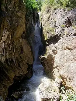 Gol Akhur waterfall | |
 Varzaqan | |
| Coordinates: 38°30′26″N 46°39′03″E[1] | |
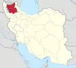
| Country | Iran |
| Province | East Azerbaijan |
| County | Varzaqan |
| District | Central |
| Population (2016)[2] | |
| • Total | 5,348 |
| Time zone | UTC+3:30 (IRST) |
| Website | www |
At the 2006 census, its population was 3,549 in 930 households.[4] The following census in 2011 counted 5,385 people in 1,392 households.[5] The latest census in 2016 showed a population of 5,348 people in 1,401 households.[2] The city is famous for the Sungun copper mine, 25 km from the city centre, which is estimated to have 3 percent of the known copper reserves in the world.
Historical landmark
The cuneiform inscription in the village of Saqandel is the most famous historical monument in the region.
Earthquakes
The area is subject to earthquakes, and in 2012 a number of people were killed when an earthquake doublet (magnitude 6.4 and 6.3) struck on the afternoon of 11 August.[6]
Economy
Farming is the predominant occupation in the rural areas. The area produces apple, pear, cherry, walnut and apricot fruit. Recently spruce trees have been planted as the start of a forestry industry. Cold water fish farming has been started.[7]
Varzeqan is a mining centre for base metal mining, as well as gold. The Sungun copper mine is now the largest copper mine in northwestern Iran. The deposit itself is one of the largest copper deposits in the world. There are nearby gold mines at Shrfabad, Hyzjan, Tshkhsrv, Astrgan, Andryan and Myvhrvd.[7]
References
- OpenStreetMap contributors (5 April 2023). "Varzaqan, Varzaqan County" (Map). OpenStreetMap. Retrieved 5 April 2023.
- "Census of the Islamic Republic of Iran, 1395 (2016)". AMAR (in Persian). The Statistical Center of Iran. p. 03. Archived from the original (Excel) on 13 November 2020. Retrieved 19 December 2022.
- Varzaqan can be found at GEOnet Names Server, at this link, by opening the Advanced Search box, entering "-3088233" in the "Unique Feature Id" form, and clicking on "Search Database".
- "Census of the Islamic Republic of Iran, 1385 (2006)". AMAR (in Persian). The Statistical Center of Iran. p. 03. Archived from the original (Excel) on 20 September 2011. Retrieved 25 September 2022.
- "Census of the Islamic Republic of Iran, 1390 (2011)" (Excel). Iran Data Portal (in Persian). The Statistical Center of Iran. p. 03. Retrieved 19 December 2022.
- "Iran earthquake relief efforts begin after 250 killed". BBC News. 12 August 2012.
- Arzyl, Ahmed Hassan Nejad ( احمد حسن نژاد ارزیل) (2010). "تاریخچه شهرستان ورزقان (History of Varzeqan)". Archived from the original on 21 August 2012. Retrieved 11 August 2012.
| Capital | |||||||||||||||||||||||||||
|---|---|---|---|---|---|---|---|---|---|---|---|---|---|---|---|---|---|---|---|---|---|---|---|---|---|---|---|
| Districts |
| ||||||||||||||||||||||||||