Mirošovice
Mirošovice is a municipality and village in Prague-East District in the Central Bohemian Region of the Czech Republic. It has about 1,500 inhabitants.
Mirošovice | |
|---|---|
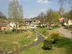 Kunický stream in Mirošovice | |
 Flag  Coat of arms | |
 Mirošovice Location in the Czech Republic | |
| Coordinates: 49°54′36″N 14°42′41″E | |
| Country | |
| Region | Central Bohemian |
| District | Prague-East |
| First mentioned | 1250 |
| Area | |
| • Total | 5.37 km2 (2.07 sq mi) |
| Elevation | 334 m (1,096 ft) |
| Population (2023-01-01)[1] | |
| • Total | 1,470 |
| • Density | 270/km2 (710/sq mi) |
| Time zone | UTC+1 (CET) |
| • Summer (DST) | UTC+2 (CEST) |
| Postal code | 251 66 |
| Website | www |
Geography
Mirošovice is located about 19 km (12 mi) southeast of Prague. It lies in the Benešov Uplands. The highest point is at 415 m (1,362 ft) above sea level.
History
The first written mention of Mirošovice is from 1250.[2]
Transport
The D1 motorway passes through the municipality. The I/3 road (part of European route E55) separates from it in Mirošovice.
Mirošovice is located on the railway line Prague–Benešov.
Sights
Mirošovice is poor in monuments. The only cultural monument are the fragments of the Ježov Castle, located at the southern municipal border. It is a torso of a medieval castle which stood here from the 13th to the 15th century.[3]
References
- "Population of Municipalities – 1 January 2023". Czech Statistical Office. 2023-05-23.
- "Základní informace" (in Czech). Obec Mirošovice. Retrieved 2023-03-11.
- "Výsledky vyhledávání: Národní kulturní památky, obec Mirošovice". Ústřední seznam kulturních památek (in Czech). National Heritage Institute. Retrieved 2023-03-11.