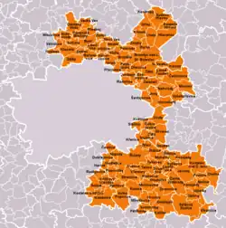
Prague-East District
Prague-East District (Czech: okres Praha-východ) is a district in the Central Bohemian Region of the Czech Republic. Its capital is Prague. The most populated town of the district is Brandýs nad Labem-Stará Boleslav.
Prague-East District
Okres Praha-východ | |
|---|---|
 Location in the Central Bohemian Region within the Czech Republic | |
 | |
| Coordinates: 50°7′N 14°42′E | |
| Country | |
| Region | Central Bohemian |
| Capital | Prague |
| Area | |
| • Total | 755.45 km2 (291.68 sq mi) |
| Population (2023)[2] | |
| • Total | 198,312 |
| • Density | 260/km2 (680/sq mi) |
| Time zone | UTC+1 (CET) |
| • Summer (DST) | UTC+2 (CEST) |
| Municipalities | 110 |
| * Towns | 8 |
| * Market towns | 4 |
Administrative division
Prague-East District is divided into two administrative districts of municipalities with extended competence: Brandýs nad Labem-Stará Boleslav and Říčany.
List of municipalities
Towns are marked in bold and market towns in italics:
Babice - Bašť - Borek - Bořanovice - Brandýs nad Labem-Stará Boleslav - Brázdim - Březí - Čelákovice - Černé Voděrady - Čestlice - Dobročovice - Dobřejovice - Doubek - Dřevčice - Dřísy - Herink - Hlavenec - Horoušany - Hovorčovice - Hrusice - Husinec - Jenštejn - Jevany - Jirny - Kaliště - Kamenice - Káraný - Klecany - Klíčany - Klokočná - Konětopy - Konojedy - Kostelec u Křížků - Kostelec nad Černými lesy - Kostelní Hlavno - Kozojedy - Křenek - Křenice - Křížkový Újezdec - Kunice - Květnice - Lázně Toušeň - Lhota - Líbeznice - Louňovice - Máslovice - Měšice - Mirošovice - Mnichovice - Modletice - Mochov - Mratín - Mukařov - Nehvizdy - Nová Ves - Nový Vestec - Nučice - Nupaky - Odolena Voda - Oleška - Ondřejov - Oplany - Panenské Břežany - Pětihosty - Petříkov - Podolanka - Polerady - Popovičky - Předboj - Přezletice - Prusice - Radějovice - Radonice - Říčany - Sedlec - Senohraby - Šestajovice - Sibřina - Škvorec - Sluhy - Sluštice - Strančice - Struhařov - Stříbrná Skalice - Sudovo Hlavno - Sulice - Štíhlice - Svémyslice - Světice - Svojetice - Tehov - Tehovec - Úvaly - Veleň - Veliká Ves - Velké Popovice - Větrušice - Vlkančice - Vodochody - Všestary - Vyšehořovice - Výžerky - Vyžlovka - Zápy - Záryby - Zdiby - Zeleneč - Zlatá - Zlonín - Zvánovice
Geography
The territory of the district forms an atypical shape, surrounding Prague from the east. From north to south, the territory measures about 80 km (50 mi), but at its narrowest point it is only 3 km (2 mi) wide. The landscape is rather flat and agricultural, only the southeast is more hilly and forested. It extends into four geomorphological mesoregions: Central Elbe Table (north), Prague Plateau (northwest and central parts), Benešov Uplands (south) and Jizera Table (small northernmost part). The highest point of the district is the hill Pecný in Ondřejov with an elevation of 545 m (1,788 ft), the lowest point is the river bed of the Elbe in Záryby at 165 m (541 ft).
From the total district area of 755.5 km2 (291.7 sq mi), agricultural land occupies 476.1 km2 (183.8 sq mi), forests occupy 169.9 km2 (65.6 sq mi), and water area occupies 12.2 km2 (4.7 sq mi). Forests cover 22.5% of the district's area.[1]
The most important river is the Elbe, which flows through the northern part of the district. The Vltava briefly forms the district border in the northwest. The territory is rather poor in bodies of water, the exception is a set of eight ponds on the Jevanský Stream. The largest of them is Jevanský Pond with an area of 22.5 ha (56 acres).[3]
There are no large-scale protected areas.
Demographics
Thanks to its proximity to Prague, Prague-East District belongs to the fastest growing districts in the country in the 21st century.
|
|
| ||||||||||||||||||||||||||||||||||||||||||||||||||||||
| Source: Censuses[4][5] | ||||||||||||||||||||||||||||||||||||||||||||||||||||||||
Most populated municipalities
| Name | Population[2] | Area (km2) |
|---|---|---|
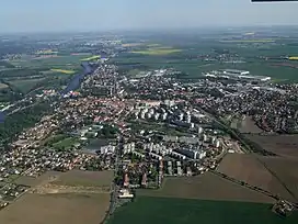
| Brandýs nad Labem-Stará Boleslav | 19,767 | 23 |
| Říčany | 16,775 | 26 |
| Čelákovice | 12,444 | 16 |
| Úvaly | 7,404 | 11 |
| Odolena Voda | 6,344 | 11 |
| Kamenice | 5,060 | 17 |
| Nehvizdy | 4,294 | 10 |
| Kostelec nad Černými lesy | 4,059 | 18 |
| Mnichovice | 4,050 | 8 |
| Šestajovice | 4,021 | 5 |
Economy
The largest employers with headquarters in Prague-East District and at least 1,000 employees are:[6]
| Economic entity | Location | Number of employees | Main activity |
|---|---|---|---|
| Billa | Modletice | 5,000–9,999 | Retail sale |
| Penny Market | Radonice | 5,000–9,999 | Retail sale |
| Teta drogerie a lékárny ČR | Šestajovice | 2,000–2,499 | Retail sale |
| Mountfield | Mnichovice | 1,500–1,999 | Retail sale |
| FAST ČR | Říčany | 1,500–1,999 | Retail sale |
| REHAU Automotive | Čestlice | 1,000–1,499 | Manufacture of plastic products |
| XLCZ Nábytek | Čestlice | 1,000–1,499 | Retail sale |
| Aero Vodochody | Odolena Voda | 1,000–1,499 | Aircraft manufacture |
Transport
The territory of the district is crossed by several motorways leading from Prague: the D1 motorway to Brno, the D8 motorway to Ústí nad Labem, the D10 motorway to Turnov, and the D11 motorway to Hradec Králové. Small part of the D0 motorway also passes through the district.
Sights

The most important monuments in the district, protected as national cultural monuments are (all located in Brandýs nad Labem-Stará Boleslav):[7]
- Church of the Assumption of the Virgin Mary
- Church of Saint Wenceslaus and Church of Saint Clement
- Brandýs nad Labem Castle
- Palladium of the Bohemian land in the Church of the Assumption of the Virgin Mary
The best-preserved settlements, protected as monument zones, are:[8]
The most visited tourist destination and one of the most visited destinations in the entire country is Aquapalace Prague in Čestlice.[9]
Notable people
References
- "Land use (as at 31 December)". Public database. Czech Statistical Office. Retrieved 2023-05-16.
- "Population of Municipalities – 1 January 2023". Czech Statistical Office. 2023-05-23.
- "Výlov Vyžlovského rybníka" (in Czech). CzechTourism. 2022-11-05. Retrieved 2023-01-13.
- "Historický lexikon obcí České republiky 1869–2011 – Okres Praha-východ" (in Czech). Czech Statistical Office. 2015-12-21. pp. 1–2.
- "Population Census 2021: Population by sex". Public Database. Czech Statistical Office. 2021-03-27.
- "Registr ekonomických subjektů". Business Register (in Czech). Czech Statistical Office. Retrieved 2023-03-30.
- "Výsledky vyhledávání: Národní kulturní památky, okres Praha-východ". Ústřední seznam kulturních památek (in Czech). National Heritage Institute. Retrieved 2023-01-13.
- "Výsledky vyhledávání: Památkové rezervace, Památkové zóny, okres Praha-východ". Ústřední seznam kulturních památek (in Czech). National Heritage Institute. Retrieved 2023-01-13.
- "Turisté mají v České republice nejraději zoologické zahrady, technické památky, koupání a Pražský hrad" (in Czech). CzechTourism. 2022-06-24. Retrieved 2023-01-19.
External links
- Prague-East District – profile on the Czech Statistical Office website