Kladno District
Kladno District (Czech: okres Kladno) is a district in the Central Bohemian Region of the Czech Republic. Its capital is the city of Kladno.
Kladno District
Okres Kladno | |
|---|---|
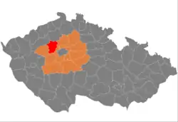 Location in the Central Bohemian Region within the Czech Republic | |
 | |
| Coordinates: 50°13′N 14°6′E | |
| Country | |
| Region | Central Bohemian |
| Capital | Kladno |
| Area | |
| • Total | 719.65 km2 (277.86 sq mi) |
| Population (2023)[2] | |
| • Total | 168,708 |
| • Density | 230/km2 (610/sq mi) |
| Time zone | UTC+1 (CET) |
| • Summer (DST) | UTC+2 (CEST) |
| Municipalities | 100 |
| * Cities and towns | 8 |
| * Market towns | 2 |
Administrative division
Kladno District is divided into two administrative districts of municipalities with extended competence: Kladno and Slaný.
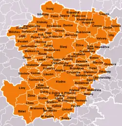
List of municipalities
Cities and towns are marked in bold and market towns in italics:
Běleč - Běloky - Beřovice - Bílichov - Blevice - Brandýsek - Braškov - Bratronice - Buštěhrad - Černuc - Chržín - Cvrčovice - Doksy - Dolany - Drnek - Družec - Dřetovice - Dřínov - Hobšovice - Horní Bezděkov - Hořešovice - Hořešovičky - Hospozín - Hostouň - Hradečno - Hrdlív - Hřebeč - Jarpice - Jedomělice - Jemníky - Kačice - Kamenné Žehrovice - Kamenný Most - Kladno - Klobuky - Kmetiněves - Knovíz - Koleč - Královice - Kutrovice - Kvílice - Kyšice - Lány - Ledce - Lhota - Libochovičky - Libovice - Libušín - Lidice - Líský - Loucká - Makotřasy - Malé Kyšice - Malé Přítočno - Malíkovice - Neprobylice - Neuměřice - Otvovice - Páleč - Pavlov - Pchery - Pletený Újezd - Plchov - Podlešín - Poštovice - Pozdeň - Přelíc - Řisuty - Sazená - Slaný - Šlapanice - Slatina - Smečno - Stehelčeves - Stochov - Stradonice - Studeněves - Svárov - Svinařov - Třebichovice - Třebíz - Třebusice - Tuchlovice - Tuřany - Uhy - Unhošť - Velká Dobrá - Velké Přítočno - Velvary - Vinařice - Vraný - Vrbičany - Zájezd - Zákolany - Želenice - Zichovec - Žilina - Žižice - Zlonice - Zvoleněves
Geography

The district is characterized by a rugged landscape without large differences in altitude, mostly flat in the north and east and hilly in the south and west. The territory extends into three geomorphological mesoregions: Lower Eger Table (north), Prague Plateau (central and eastern part), Křivoklát Highlands (south) and Džbán (small part in the west). The highest point of the district is the hill Tuchonín in Malé Kyšice with an elevation of 488 m (1,601 ft), the lowest point is the river bed of the Bakovský Stream in Sazená at 172 m (564 ft).
From the total district area of 719.7 km2 (277.9 sq mi), agricultural land occupies 474.5 km2 (183.2 sq mi), forests occupy 145.9 km2 (56.3 sq mi), and water area occupies 7.3 km2 (2.8 sq mi). Forests cover 20.3% of the district's area.[1]
There are no major rivers. The most important watercourses are the Loděnice River (a tributary of the Berounka), which crosses the southern part of the district, and the Bakovský Stream, which flows across the northern part and then joins the Vltava just beyond the district border. There are relatively many small ponds in the area. The largest pond is Turyňský with an area of 51 ha (130 acres). A notable body of water is also Klíčava Reservoir, which lies only partially in the district.
Křivoklátsko is the only protected landscape area that extends into the district, in its southwestern part.
Demographics
|
|
| ||||||||||||||||||||||||||||||||||||||||||||||||||||||
| Source: Censuses[3][4] | ||||||||||||||||||||||||||||||||||||||||||||||||||||||||
Economy
The largest employers with headquarters in Kladno District and at least 1,000 employees are:[5]
| Economic entity | Location | Number of employees | Main activity |
|---|---|---|---|
| Lego Production | Kladno | 3,000–3,999 | Manufacture of toys |
| Regional Hospital Kladno | Kladno | 1,500–1,999 | Health care |
| Medical rescue service of the Central Bohemian Region | Kladno | 1,000–1,499 | Health care |
| Linet | Slaný | 1,000–1,499 | Production of medical equipment |
Transport
The D7 motorway from Prague to Chomutov, including the unfinished section, leads across the district. The D6 motorway from Prague to Karlovy Vary passes through the southern part of the district.
Sights
The most important monuments in the district, protected as national cultural monuments, are:[6]
- Lidice Memorial in Lidice
- Medieval gord of Budeč
- Tomb of Tomáš Garrigue Masaryk in Lány
The best-preserved settlements, protected as monument reservations and monument zones, are:[7]
The most visited tourist destination is the Lidice Memorial.[8]
Notable people
References
- "Land use (as at 31 December)". Public database. Czech Statistical Office. Retrieved 2023-05-16.
- "Population of Municipalities – 1 January 2023". Czech Statistical Office. 2023-05-23.
- "Historický lexikon obcí České republiky 1869–2011 – Okres Kladno" (in Czech). Czech Statistical Office. 2015-12-21. pp. 7–8.
- "Population Census 2021: Population by sex". Public Database. Czech Statistical Office. 2021-03-27.
- "Registr ekonomických subjektů". Business Register (in Czech). Czech Statistical Office. Retrieved 2023-01-17.
- "Výsledky vyhledávání: Národní kulturní památky, okres Kladno". Ústřední seznam kulturních památek (in Czech). National Heritage Institute. Retrieved 2023-01-04.
- "Výsledky vyhledávání: Památkové rezervace, Památkové zóny, okres Kladno". Ústřední seznam kulturních památek (in Czech). National Heritage Institute. Retrieved 2023-01-04.
- "Návštěvnost muzeí, galerií a památníků 2021" (in Czech). Národní informační a poradenské středisko pro kulturu. Retrieved 2023-01-30.
External links
- Kladno District – profile on the Czech Statistical Office website