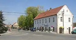
Stehelčeves
Stehelčeves is a municipality and village in Kladno District in the Central Bohemian Region of the Czech Republic. It has about 1,100 inhabitants.
Stehelčeves | |
|---|---|
 Municipal office | |
 Flag  Coat of arms | |
 Stehelčeves Location in the Czech Republic | |
| Coordinates: 50°10′18″N 14°11′27″E | |
| Country | |
| Region | Central Bohemian |
| District | Kladno |
| First mentioned | 1316 |
| Area | |
| • Total | 4.98 km2 (1.92 sq mi) |
| Elevation | 276 m (906 ft) |
| Population (2023-01-01)[1] | |
| • Total | 1,117 |
| • Density | 220/km2 (580/sq mi) |
| Time zone | UTC+1 (CET) |
| • Summer (DST) | UTC+2 (CEST) |
| Postal code | 273 42 |
| Website | www |
Geography
Stehelčeves is located about 6 kilometres (4 mi) northeast of Kladno and 22 km (14 mi) northwest of Prague. It lies in the Prague Plateau. An artificial hill known as Buštěhrad slag heap is located in the southern part of the municipality. The Dřetovický Stream flows through the municipality and supplies Vrapický Pond.
History
The first written mention of Stehelčeves is from 1316. At the beginning of the 16th century, the village was acquired by the Kolowrat family.[2]
Transport
The D7 motorway runs along the eastern municipal border.
Sights
Stehelčeves is poor in monuments. There used to be a chapel from the first half of the 18th century, but it was destroyed by vandals in the 1950s.[2] There are remnants of an eneolithic hillfort called Homolka, which have been archaeologically explored.[3]
References
- "Population of Municipalities – 1 January 2023". Czech Statistical Office. 2023-05-23.
- "Historie obce" (in Czech). Obec Stehelčeves. Retrieved 2023-04-05.
- "Výsledky vyhledávání: Kulturní památky, obec Stehelčeves". Ústřední seznam kulturních památek (in Czech). National Heritage Institute. Retrieved 2023-04-05.