Zákolany
Zákolany is a municipality and village in Kladno District in the Central Bohemian Region of the Czech Republic. It has about 600 inhabitants.
Zákolany | |
|---|---|
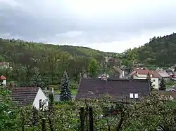 General view of the village | |
 Flag  Coat of arms | |
 Zákolany Location in the Czech Republic | |
| Coordinates: 50°11′49″N 14°14′56″E | |
| Country | |
| Region | Central Bohemian |
| District | Kladno |
| First mentioned | 1282 |
| Area | |
| • Total | 5.68 km2 (2.19 sq mi) |
| Elevation | 235 m (771 ft) |
| Population (2023-01-01)[1] | |
| • Total | 635 |
| • Density | 110/km2 (290/sq mi) |
| Time zone | UTC+1 (CET) |
| • Summer (DST) | UTC+2 (CEST) |
| Postal code | 273 28 |
| Website | www |
Administrative parts
Villages of Kováry and Trněný Újezd are administrative parts of Zákolany.
Geography
Zákolany is located about 11 kilometres (7 mi) northeast of Kladno and 15 km (9 mi) northwest of Prague. It lies in the Prague Plateau. The villages of Zákolany and Kováry are situated in the valley of the Zákolanský Stream.
History
The first written mention of Zákolany is from 1282.[2]
Sights
Zákolany is known for Budeč, which was a 22 ha (54 acres) large gord founded by the first members of the Přemyslid dynasty. The Rotunda of Saints Peter and Paul was built here after 895. The nave of the rotunda is the oldest preserved building in the Czech Republic.[3]
Notable people
- Wenceslaus I (c. 907 – c. 935), Duke of Bohemia, saint; studied in Budeč
- Antonín Zápotocký (1884–1957), communist politician, president of Czechoslovakia in 1953–1957
References
- "Population of Municipalities – 1 January 2023". Czech Statistical Office. 2023-05-23.
- "Místopis: Zákolany" (in Czech). Obec Zákolany. Retrieved 2022-03-01.
- "Budeč u Zákolan – rotunda Petra a Pavla" (in Czech). CzechTourism. Retrieved 2022-05-11.