Rakovník District
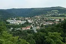
Rakovník District (Czech: okres Rakovník) is a district in the Central Bohemian Region of the Czech Republic. Its capital is the town of Rakovník.
Rakovník District
Okres Rakovník | |
|---|---|
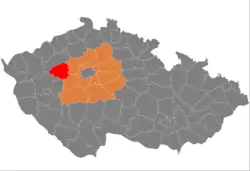 Location in the Central Bohemian Region within the Czech Republic | |
 | |
| Coordinates: 50°6′N 13°44′E | |
| Country | |
| Region | Central Bohemian |
| Capital | Rakovník |
| Area | |
| • Total | 896.29 km2 (346.06 sq mi) |
| Population (2023)[2] | |
| • Total | 56,058 |
| • Density | 63/km2 (160/sq mi) |
| Time zone | UTC+1 (CET) |
| • Summer (DST) | UTC+2 (CEST) |
| Municipalities | 83 |
| * Towns | 3 |
| * Market towns | 6 |
Administrative division
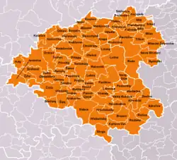
Rakovník District is formed by only one administrative district of municipality with extended competence: Rakovník.
List of municipalities
Towns are marked in bold and market towns in italics:
Bdín - Branov - Břežany - Chrášťany - Čistá - Děkov - Drahouš - Hořesedly - Hořovičky - Hracholusky - Hřebečníky - Hředle - Hvozd - Janov - Jesenice - Kalivody - Karlova Ves - Kněževes - Kolešov - Kolešovice - Kounov - Kozojedy - Krakov - Krakovec - Kroučová - Krty - Krupá - Krušovice - Křivoklát - Lašovice - Lišany - Lubná - Lužná - Malinová - Městečko - Milostín - Milý - Mšec - Mšecké Žehrovice - Mutějovice - Nesuchyně - Nezabudice - Nové Strašecí - Nový Dům - Olešná - Oráčov - Panoší Újezd - Pavlíkov - Petrovice - Pochvalov - Přerubenice - Příčina - Přílepy - Pšovlky - Pustověty - Račice - Rakovník - Řeřichy - Řevničov - Roztoky - Ruda - Rynholec - Šanov - Senec - Senomaty - Šípy - Skryje - Slabce - Smilovice - Srbeč - Švihov - Svojetín - Sýkořice - Třeboc - Třtice - Václavy - Velká Buková - Velká Chmelištná - Všesulov - Všetaty - Zavidov - Zbečno - Žďár
Geography
Slightly undulating plateaus and hilly landscape are typical for the district. The territory extends into four geomorphological mesoregions: Rakovník Uplands (west), Plasy Uplands (southwest), Křivoklát Highlands (southeast) and Džbán (north). The highest point of the district is the hill Vlastec in Skryje with an elevation of 612 m (2,008 ft), the lowest point is the river bed of the Berounka in Račice at 224 m (735 ft).
From the total district area of 896.3 km2 (346.1 sq mi), agricultural land occupies 468.6 km2 (180.9 sq mi), forests occupy 341.7 km2 (131.9 sq mi), and water area occupies 12.5 km2 (4.8 sq mi). Forests cover 38.1% of the district's area.[1]
The most important river is the Berounka, which flows through a valley in the southern part of the district. The second notable river is the Loděnice, which springs here and supplies several ponds. The largest body of water is Klíčava Reservoir, even if it lies only partially in the district.
Křivoklátsko is the only protected landscape area. It covers a large part of the district in its southern and eastern parts.
Demographics
|
|
| ||||||||||||||||||||||||||||||||||||||||||||||||||||||
| Source: Censuses[3][4] | ||||||||||||||||||||||||||||||||||||||||||||||||||||||||
Economy
The largest employers with headquarters in Rakovník District and at least 250 employees are:[5]
| Economic entity | Location | Number of employees | Main activity |
|---|---|---|---|
| Valeo Autoklimatizace | Rakovník | 2,000–2,499 | Manufacture of car air conditioners |
| Heineken Česká republika | Krušovice | 250–499 | Production of beverages |
| Anexia | Rakovník | 250–499 | Freight transport by road |
| Procter & Gamble – Rakona | Rakovník | 250–499 | Manufacture of cosmetics |
| Purem Rakovník | Rakovník | 250–499 | Automotive industry |
| Town of Rakovník | Rakovník | 250–499 | Public administration |
Transport
The D6 motorway from Prague to Karlovy Vary, including its unfinished section, passes through the district.
Sights
The most important monuments in the district, protected as national cultural monuments, are:[6]
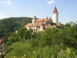
- Křivoklát Castle
- Sokol house in Rakovník
The best-preserved settlements, protected as monument zones, are:[7]
The most visited tourist destination is the Křivoklát Castle.[8]
Notable people
References
- "Land use (as at 31 December)". Public database. Czech Statistical Office. Retrieved 2023-05-16.
- "Population of Municipalities – 1 January 2023". Czech Statistical Office. 2023-05-23.
- "Historický lexikon obcí České republiky 1869–2011 – Okres Rakovník" (in Czech). Czech Statistical Office. 2015-12-21. pp. 1–2.
- "Population Census 2021: Population by sex". Public Database. Czech Statistical Office. 2021-03-27.
- "Registr ekonomických subjektů". Business Register (in Czech). Czech Statistical Office. Retrieved 2023-03-30.
- "Výsledky vyhledávání: Národní kulturní památky, okres Rakovník". Ústřední seznam kulturních památek (in Czech). National Heritage Institute. Retrieved 2023-01-11.
- "Výsledky vyhledávání: Památkové rezervace, Památkové zóny, okres Rakovník". Ústřední seznam kulturních památek (in Czech). National Heritage Institute. Retrieved 2023-01-11.
- "Návštěvnost památek 2021" (in Czech). Národní informační a poradenské středisko pro kulturu. Retrieved 2023-01-30.
External links
- Rakovník District – profile on the Czech Statistical Office website