Pochvalov
Pochvalov is a municipality and village in Rakovník District in the Central Bohemian Region of the Czech Republic. It has about 200 inhabitants.
Pochvalov | |
|---|---|
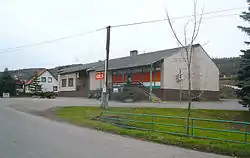 Grocery store | |
 Flag  Coat of arms | |
 Pochvalov Location in the Czech Republic | |
| Coordinates: 50°13′39″N 13°47′40″E | |
| Country | |
| Region | Central Bohemian |
| District | Rakovník |
| First mentioned | 1346 |
| Area | |
| • Total | 4.55 km2 (1.76 sq mi) |
| Elevation | 382 m (1,253 ft) |
| Population (2023-01-01)[1] | |
| • Total | 249 |
| • Density | 55/km2 (140/sq mi) |
| Time zone | UTC+1 (CET) |
| • Summer (DST) | UTC+2 (CEST) |
| Postal code | 270 55 |
| Website | www |
Geography
Pochvalov is located about 14 km (9 mi) north of Rakovník and 43 km (27 mi) northwest of Prague. It lies in the Džbán range. The highest point is at 485 m (1,591 ft) above sea level.
History
The first written mention of Pochvalov is from 1346, when it belonged to the Knights Hospitaller. Later it was the property of various noble families. Among the most notable owners of Pochvalov were the Zierotin and Lobkowicz families.[2]
In the years 1939–1950, the Jiřina coal mine was in operation near the village.[3]
Economy
The area is known for growing hops.
Sights
The most important monument is the Chapel of Saint Procopius. It is a large Baroque chapel from the mid-18th century.[4]
References
- "Population of Municipalities – 1 January 2023". Czech Statistical Office. 2023-05-23.
- "Pochvalov (Česko)" (in Czech). Středočeská vědecká knihovna v Kladně. Retrieved 2023-07-18.
- Majer, Martin; Somol, Václav; Žák, Karel (2020). Džbán. Krajina opukových plošin (in Czech). Vrchlabí: Green Mango. pp. 154, 232. ISBN 978-80-270-7006-0.
- "Kaple sv. Prokopa" (in Czech). National Heritage Institute. Retrieved 2023-07-18.