Hořesedly
Hořesedly (German: Horosedl) is a municipality and village in Rakovník District in the Central Bohemian Region of the Czech Republic. It has about 400 inhabitants.
Hořesedly | |
|---|---|
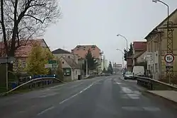 Main street | |
 Flag  Coat of arms | |
 Hořesedly Location in the Czech Republic | |
| Coordinates: 50°9′45″N 13°36′10″E | |
| Country | |
| Region | Central Bohemian |
| District | Rakovník |
| First mentioned | 1316 |
| Area | |
| • Total | 5.84 km2 (2.25 sq mi) |
| Elevation | 379 m (1,243 ft) |
| Population (2023-01-01)[1] | |
| • Total | 413 |
| • Density | 71/km2 (180/sq mi) |
| Time zone | UTC+1 (CET) |
| • Summer (DST) | UTC+2 (CEST) |
| Postal code | 270 04 |
| Website | www |
Geography
Hořesedly is located about 11 km (7 mi) northwest of Rakovník and 53 km (33 mi) west of Prague. It lies in an agricultural landscape in the Rakovník Uplands. The highest point is the hill Cikán at 437 m (1,434 ft) above sea level.
History
The first written mention of Hořesedly is from 1316. From 1355 to 1418, it was property of the church at Prague Castle. In 1420, Hořesedly was shortly owned by a branch of the Kolowrat family, then it was confiscated from them by the royal chamber and passed on to various lesser nobles.[2]
Transport
The I/6 road, part of the European route E48, passes through the municipality. It replaces the unfinished section of the D6 motorway from Prague to Karlovy Vary.
Sights
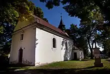
The main landmark of Hořesedly is the Church of Saint Lawrence. It is a small Baroque church from the early 18th century.[2][3]
References
- "Population of Municipalities – 1 January 2023". Czech Statistical Office. 2023-05-23.
- "Historie obce" (in Czech). Obec Hořesedly. Retrieved 2023-02-15.
- "Kostel sv. Vavřince" (in Czech). National Heritage Institute. Retrieved 2023-02-15.