Kolešov
Kolešov is a municipality and village in Rakovník District in the Central Bohemian Region of the Czech Republic. It has about 100 inhabitants.
Kolešov | |
|---|---|
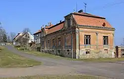 Eastern part of Kolešov | |
 Flag  Coat of arms | |
 Kolešov Location in the Czech Republic | |
| Coordinates: 50°9′26″N 13°30′36″E | |
| Country | |
| Region | Central Bohemian |
| District | Rakovník |
| First mentioned | 1319 |
| Area | |
| • Total | 5.15 km2 (1.99 sq mi) |
| Elevation | 385 m (1,263 ft) |
| Population (2023-01-01)[1] | |
| • Total | 143 |
| • Density | 28/km2 (72/sq mi) |
| Time zone | UTC+1 (CET) |
| • Summer (DST) | UTC+2 (CEST) |
| Postal code | 270 04 |
| Website | www |
Geography
Kolešov is located about 16 km (10 mi) northwest of Rakovník and 60 km (37 mi) west of Prague. It lies in an agricultural landscape in the Rakovník Uplands. The highest point is the hill Liščí vrch at 436 m (1,430 ft) above sea level.
History
The first written mention of Kolešov is from 1319.[2]
Transport
There is an intersection of two important roads: the I/6 road, part of the European route E48, which replaces the unfinished section of the D6 motorway from Prague to Karlovy Vary, and the I/27 road, leading from Plzeň to Most.
Sights
There are no sights protected as cultural monuments.[3] In the centre of Kolešov is a small chapel.
References
- "Population of Municipalities – 1 January 2023". Czech Statistical Office. 2023-05-23.
- "Historické souvislosti". Obec Kolešovlanguage=cs. Retrieved 2023-02-17.
- "Výsledky vyhledávání: Kulturní památky, okres Rakovník" (in Czech). National Heritage Institute. Retrieved 2023-02-17.