Pavlíkov
Pavlíkov is a market town in Rakovník District in the Central Bohemian Region of the Czech Republic. It has about 1,100 inhabitants.
Pavlíkov | |
|---|---|
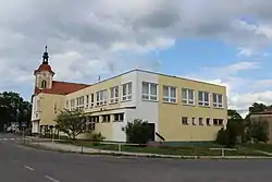 Municipal office | |
 Flag  Coat of arms | |
 Pavlíkov Location in the Czech Republic | |
| Coordinates: 50°3′22″N 13°44′11″E | |
| Country | |
| Region | Central Bohemian |
| District | Rakovník |
| First mentioned | 1422 |
| Area | |
| • Total | 39.46 km2 (15.24 sq mi) |
| Elevation | 462 m (1,516 ft) |
| Population (2023-01-01)[1] | |
| • Total | 1,060 |
| • Density | 27/km2 (70/sq mi) |
| Time zone | UTC+1 (CET) |
| • Summer (DST) | UTC+2 (CEST) |
| Postal code | 270 21 |
| Website | www |
Administrative parts
Villages of Chlum, Ryšín, Skřivaň and Tytry are administrative parts of Pavlíkov.
Geography
Pavlíkov is located about 11 km (7 mi) south of Rakovník and 41 km (25 mi) west of Prague. It lies mostly in the Plasy Uplands, only the northern part of the municipal territory extends into the Křivoklát Highlands. The highest point is the hill Senecká hora at 506 m (1,660 ft) above sea level. The Rakovnický Stream flows through the territory. The northern and southern part of the territory lie in the Křivoklátsko Protected Landscape Area.
History
The first written mention of Pavlíkov is from 1422. The settlement was founded around 1341.[2]
Sights
The landmark of Pavlíkov is the Church of Saint Catherine. It was built in the late Baroque style in 1776–1785. It replaced an old church from the 14th century.[3]
The Church of Saint Stephan is located in Skřivaň. It is a late Renaissance building, modified into its current appearance in the first half of the 19th century.[4][5]
Next to the church is a small rural Renaissance castle, which was founded in the second half of the 16th century. Neoclassicat modifications took place in the first half of the 19th century,then it was insensitively modernized in the 20th century.[6]
On Senecká hora above the market town is an observation tower. It was built in 2014–2015. It is 21.5 m (71 ft) high.[7]
Notable people
- Jiří Čadek (1935–2021), footballer
- Jiří Anderle (born 1936), painter and graphic artist
References
- "Population of Municipalities – 1 January 2023". Czech Statistical Office. 2023-05-23.
- "Pavlíkovská radnice 1/2015" (in Czech). Městys Pavlíkov. 2015-03-19. p. 7. Retrieved 2023-03-08.
- "Kostel sv. Kateřiny" (in Czech). National Heritage Institute. Retrieved 2023-03-08.
- "Kostel sv. Štěpána" (in Czech). National Heritage Institute. Retrieved 2023-03-08.
- "Památky" (in Czech). Městys Pavlíkov. Retrieved 2023-03-08.
- "Zámek" (in Czech). National Heritage Institute. Retrieved 2023-03-08.
- "Rozhledna" (in Czech). Městys Pavlíkov. Retrieved 2023-03-08.