Beroun District
Beroun District (Czech: okres Beroun) is a district in the Central Bohemian Region of the Czech Republic. Its capital is the town of Beroun.
Beroun District
Okres Beroun | |
|---|---|
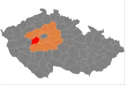 Location in the Central Bohemian Region within the Czech Republic | |
 | |
| Coordinates: 49°56′N 14°1′E | |
| Country | |
| Region | Central Bohemian |
| Capital | Beroun |
| Area | |
| • Total | 703.64 km2 (271.68 sq mi) |
| Population (2023)[2] | |
| • Total | 100,517 |
| • Density | 140/km2 (370/sq mi) |
| Time zone | UTC+1 (CET) |
| • Summer (DST) | UTC+2 (CEST) |
| Municipalities | 85 |
| * Towns | 6 |
| * Market towns | 4 |
Administrative division
Beroun District is divided into two administrative districts of municipalities with extended competence: Beroun and Hořovice.
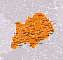
List of municipalities
Towns are marked in bold and market towns in italics:
Bavoryně - Beroun - Běštín - Březová - Broumy - Bubovice - Bykoš - Bzová - Cerhovice - Chaloupky - Chlustina - Chodouň - Chrustenice - Chyňava - Drozdov - Felbabka - Hlásná Třebaň - Hořovice - Hostomice - Hředle - Hudlice - Hvozdec - Hýskov - Jivina - Karlštejn - Komárov - Koněprusy - Korno - Kotopeky - Králův Dvůr - Kublov - Lážovice - Lhotka - Libomyšl - Liteň - Loděnice - Lochovice - Lužce - Malá Víska - Málkov - Měňany - Mezouň - Mořina - Mořinka - Nenačovice - Nesvačily - Neumětely - Nižbor - Nový Jáchymov - Olešná - Osek - Osov - Otmíče - Otročiněves - Podbrdy - Podluhy - Praskolesy - Rpety - Skřipel - Skuhrov - Srbsko - Stašov - Suchomasty - Svatá - Svatý Jan pod Skalou - Svinaře - Tetín - Tlustice - Tmaň - Točník - Trubín - Trubská - Újezd - Velký Chlumec - Vinařice - Vižina - Vráž - Všeradice - Vysoký Újezd - Zadní Třebaň - Zaječov - Záluží - Zdice - Žebrák - Železná
Geography

A hilly landscape is typical for the district. The territory extends into three geomorphological mesoregions: Křivoklát Highlands (north), Hořovice Uplands (central part) and Brdy Highlands (south). The highest point of the district is the hill Jordán in Zaječov with an elevation of 826 m (2,710 ft), the lowest point is the river basin of the Berounka in Zadní Třebaň at 211 m (692 ft).
From the total district area of 703.6 km2 (271.7 sq mi), agricultural land occupies 343.8 km2 (132.7 sq mi), forests occupy 272.8 km2 (105.3 sq mi), and water area occupies 9.1 km2 (3.5 sq mi). Forests cover 38.8% of the district's area.[1]
The most important river is the Berounka, which drains the entire territory. Its longest tributary is the Litavka. The area is very poor in bodies of water.
There are three protected landscape areas: Bohemian Karst, Brdy and Křivoklátsko.
Demographics
|
|
| ||||||||||||||||||||||||||||||||||||||||||||||||||||||
| Source: Censuses[3][4] | ||||||||||||||||||||||||||||||||||||||||||||||||||||||||
Economy
The largest employers with headquarters in Beroun District and at least 500 employees are:[5]
| Economic entity | Location | Number of employees | Main activity |
|---|---|---|---|
| Tipsport | Beroun | 1,500–1,999 | Betting agency |
| GZ Media | Loděnice | 1,500–1,999 | Manufacture of vinyls |
| Carrier Refrigeration Operation | Beroun | 1,000–1,499 | Manufacture of refrigeration systems |
| Cembrit | Beroun | 500–999 | Manufacture of fibre-cement products |
| Saint-Gobain Sekurit ČR | Hořovice | 500–999 | Manufacture of flat glass |
| Arriva Střední Čechy | Králův Dvůr | 500–999 | Passenger transport |
| GZ Production | Loděnice | 500–999 | Manufacture of vinyls |
| Mubea | Žebrák | 500–999 | Manufacture of machinery and equipment |
| Mubea Transmission Components | Žebrák | 500–999 | Manufacture of rubber and plastic products |
| Valeo Výměníky Tepla | Žebrák | 500–999 | Manufacture of heating systems |
Transport
The D5 motorway from Prague to Plzeň and the border with Germany passes through the district.
Sights
The most important monuments in the district, protected as national cultural monuments, are:[6]
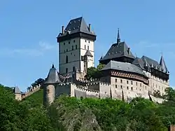
- Karlštejn Castle
- Ruins of the castles Žebrák and Točník
- Hořovice Castle
- Benedictine monastery in Svatý Jan pod Skalou
The best-preserved settlements and landscapes, protected as monument zones, are:[7]
The most visited tourist destination is the Karlštejn Castle.[8]
Notable people
References
- "Land use (as at 31 December)". Czech Statistical Office. Retrieved 2023-05-16.
- "Population of Municipalities – 1 January 2023". Czech Statistical Office. 2023-05-23.
- "Historický lexikon obcí České republiky 1869–2011 – Okres Beroun" (in Czech). Czech Statistical Office. 2015-12-21. pp. 1–2.
- "Population Census 2021: Population by sex". Public Database. Czech Statistical Office. 2021-03-27.
- "Registr ekonomických subjektů". Business Register (in Czech). Czech Statistical Office. Retrieved 2023-01-17.
- "Výsledky vyhledávání: Národní kulturní památky, okres Beroun". Ústřední seznam kulturních památek (in Czech). National Heritage Institute. Retrieved 2023-01-03.
- "Výsledky vyhledávání: Památkové rezervace, Památkové zóny, okres Beroun". Ústřední seznam kulturních památek (in Czech). National Heritage Institute. Retrieved 2023-01-03.
- "Turisté mají v České republice nejraději zoologické zahrady, technické památky, koupání a Pražský hrad" (in Czech). CzechTourism. 2022-06-24. Retrieved 2023-01-19.
External links
- Beroun District – profile on the Czech Statistical Office website