Malá Víska
Malá Víska is a municipality and village in Beroun District in the Central Bohemian Region of the Czech Republic. It has about 100 inhabitants.
Malá Víska | |
|---|---|
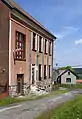
.jpg.webp) Lower part of Malá Víska | |
 Flag  Coat of arms | |
 Malá Víska Location in the Czech Republic | |
| Coordinates: 49°46′34″N 13°52′32″E | |
| Country | |
| Region | Central Bohemian |
| District | Beroun |
| First mentioned | 1520 |
| Area | |
| • Total | 10.19 km2 (3.93 sq mi) |
| Elevation | 550 m (1,800 ft) |
| Population (2023-01-01)[1] | |
| • Total | 105 |
| • Density | 10/km2 (27/sq mi) |
| Time zone | UTC+1 (CET) |
| • Summer (DST) | UTC+2 (CEST) |
| Postal code | 267 62 |
| Website | www |
Geography
Malá Víska is located about 24 kilometres (15 mi) southwest of Beroun and 45 km (28 mi) southwest of Prague. It lies in the Brdy Highlands. The highest point is at 822 m (2,697 ft) above sea level. Except for the built-up area, the municipality is located in the Brdy Protected Landscape Area.
History
The first written mention of Malá Víska is from 1520. The village was founded as a settlement of woodworkers, charcoal burners and coal miners.[2]
Sights
Malá Víska is poor in monuments. The only protected cultural monument is a military bunker from the early 1930s called Jordán. It is the most important test object of heavy fortification in the Czech Republic.[3]
Gallery
 Former school, now municipal office
_01.jpg.webp) Small chapel
Small chapel
References
- "Population of Municipalities – 1 January 2023". Czech Statistical Office. 2023-05-23.
- "Historie" (in Czech). Obec Malá Víska. Retrieved 2023-06-14.
- "Výsledky vyhledávání: Kulturní památky, obec Malá Víska". Ústřední seznam kulturních památek (in Czech). National Heritage Institute. Retrieved 2023-06-14.