Chyňava
Chyňava is a municipality and village in Beroun District in the Central Bohemian Region of the Czech Republic. It has about 1,900 inhabitants.
Chyňava | |
|---|---|
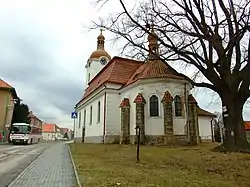
 Church of Saint Procopius | |
 Flag  Coat of arms | |
 Chyňava Location in the Czech Republic | |
| Coordinates: 50°1′39″N 14°4′27″E | |
| Country | |
| Region | Central Bohemian |
| District | Beroun |
| First mentioned | 1341 |
| Area | |
| • Total | 37.94 km2 (14.65 sq mi) |
| Elevation | 397 m (1,302 ft) |
| Population (2023-01-01)[1] | |
| • Total | 1,871 |
| • Density | 49/km2 (130/sq mi) |
| Time zone | UTC+1 (CET) |
| • Summer (DST) | UTC+2 (CEST) |
| Postal codes | 266 01, 267 07 |
| Website | www |
Administrative parts
Villages of Lhotka u Berouna, Libečov, Malé Přílepy and Podkozí are administrative parts of Chyňava.
Geography
Chyňava is located about 7 km (4 mi) north of Beroun and 17 km (11 mi) west of Prague. It lies in the Křivoklát Highlands. The highest point is the Pelechovka hill at 471 m (1,545 ft) above sea level. The Loděnice River flows along the municipal border.
History
The first written mention of Chyňava is from 1341. From 1357 to 1585, the village was part of the Karlštejn estate and shared its owners and destiny. During the Hussite Wars, Chyňava suffered and the population decreased. From 1585, Chyňava belonged to the Křivoklát estate. During the Thirty Years' War, Chyňava was heavily damaged and the population decreased significantly again, but the village slowly recovered.[2]
Sights
The landmark of Chyňava is the Church of Saint Procopius. It was originally a medieval church, which was rebuilt in the Baroque style in 1779–1782 and then in the neo-Baroque style in 1914.[3]
References
- "Population of Municipalities – 1 January 2023". Czech Statistical Office. 2023-05-23.
- "Historie" (in Czech). Obec Chyňava. Retrieved 2023-03-13.
- "Kostel sv. Prokopa" (in Czech). National Heritage Institute. Retrieved 2023-03-06.
- "Valle di Ledro" (in Czech). Město Příbram. Retrieved 2023-06-28.