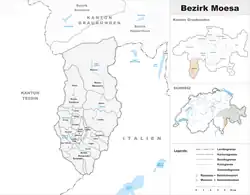
Moesa District
Moesa District, often referred to as Moesano, is a former administrative district in the canton of Graubünden, Switzerland. It had an area of 473.74 km2 (182.91 sq mi) corresponding to the Val Mesolcina, the valley of the eponymous Moesa River. It was replaced with the Moesa Region on 1 January 2017 as part of a reorganization of the Canton.[1]
Moesa
Distretto di Moesa | |
|---|---|
District | |
 | |
| Country | |
| Canton | |
| Capital | Roveredo |
| Area | |
| • Total | 473.74 km2 (182.91 sq mi) |
| Population (December 2015) | |
| • Total | 8,125 |
| • Density | 17/km2 (44/sq mi) |
| Time zone | UTC+1 (CET) |
| • Summer (DST) | UTC+2 (CEST) |
| Municipalities | 14 |
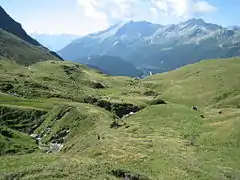
Moesa scenery
It had a population of 8,125 in 2015. The official language is Italian.
It consisted of three Kreise (circles) and fourteen municipalities:
| Calanca circle | ||||
|---|---|---|---|---|
| Municipality | Population (31 December 2020)[2] | Area (km²) | ||
| Buseno | 91 | 11.26 | ||
| Calanca | 201 | 37.72 | ||
| Castaneda | 278 | 3.94 | ||
| Rossa | 151 | 58.93 | ||
| Santa Maria in Calanca | 115 | 9.32 | ||
Languages
The official language of Moesa is Italian, traditionally the Western Lombard dialect spoken by the native population.
| Languages of Moesa District, GR | ||||||
| Languages | Census 2000 | |||||
| Number | Percent | |||||
| German | 528 | 7.1% | ||||
| Romansh | 10 | 0.1% | ||||
| Italian | 6,578 | 88.0% | ||||
| TOTAL | 7,471 | 100% | ||||
Mergers and name changes
On 1 January 2015 the former municipalities of Arvigo, Braggio, Selma and Cauco merged to form the new municipality of Calanca.[3]
References
- Swiss Federal Statistical Office - Amtliches Gemeindeverzeichnis der Schweiz - Mutationsmeldungen 2016 accessed 16 February 2017
- "Ständige und nichtständige Wohnbevölkerung nach institutionellen Gliederungen, Geburtsort und Staatsangehörigkeit". bfs.admin.ch (in German). Swiss Federal Statistical Office - STAT-TAB. 31 December 2020. Retrieved 21 September 2021.
- Amtliches Gemeindeverzeichnis der Schweiz published by the Swiss Federal Statistical Office (in German) accessed 2 January 2013
This article is issued from Wikipedia. The text is licensed under Creative Commons - Attribution - Sharealike. Additional terms may apply for the media files.