Montreuillon
Montreuillon (French pronunciation: [mɔ̃tʁœjɔ̃]) is a commune in the Nièvre department in central France.[3]
Montreuillon | |
|---|---|
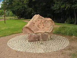 Former centre of the Eurozone | |
Location of Montreuillon | |
 Montreuillon  Montreuillon | |
| Coordinates: 47°10′29″N 3°47′20″E | |
| Country | France |
| Region | Bourgogne-Franche-Comté |
| Department | Nièvre |
| Arrondissement | Clamecy |
| Canton | Château-Chinon |
| Government | |
| • Mayor (2021–2026) | Alexandre Couvenant[1] |
| Area 1 | 35.55 km2 (13.73 sq mi) |
| Population | 258 |
| • Density | 7.3/km2 (19/sq mi) |
| Time zone | UTC+01:00 (CET) |
| • Summer (DST) | UTC+02:00 (CEST) |
| INSEE/Postal code | 58179 /58800 |
| Elevation | 229–426 m (751–1,398 ft) |
| 1 French Land Register data, which excludes lakes, ponds, glaciers > 1 km2 (0.386 sq mi or 247 acres) and river estuaries. | |
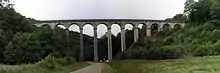
Montreuillon Aqueduct
Demographics
On 1 January 2019, the estimated population was 259.
Eurozone
Montreuillon was the official centre of the Eurozone between 2001 and 2007.
Canal du Nivernais
It is the site of an impressive aqueduct over which runs the feeder canal linking the Pannecière reservoir with the Canal du Nivernais.
References
- "Répertoire national des élus: les maires". data.gouv.fr, Plateforme ouverte des données publiques françaises (in French). 1 February 2022.
- "Populations légales 2020". The National Institute of Statistics and Economic Studies. 29 December 2022.
- INSEE commune file
Wikimedia Commons has media related to Montreuillon.
This article is issued from Wikipedia. The text is licensed under Creative Commons - Attribution - Sharealike. Additional terms may apply for the media files.