National Register of Historic Places listings in Canadian County, Oklahoma
This is a list of the National Register of Historic Places listings in Canadian County, Oklahoma.
Location of Canadian County in Oklahoma
This is intended to be a complete list of the properties and districts on the National Register of Historic Places in Canadian County, Oklahoma, United States. The locations of National Register properties and districts for which the latitude and longitude coordinates are included below, may be seen in a map.[1]
There are 24 properties and districts listed on the National Register in the county.
This National Park Service list is complete through NPS recent listings posted October 20, 2023.[2]
Current listings
| [3] | Name on the Register[4] | Image | Date listed[5] | Location | City or town | Description |
|---|---|---|---|---|---|---|
| 1 | Avant's Cities Service Station | 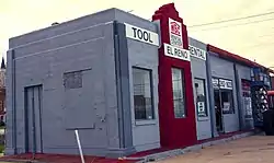 Avant's Cities Service Station |
March 2, 2004 (#04000131) |
220 S. Choctaw 35°31′53″N 97°57′17″W |
El Reno | |
| 2 | Bridgeport Hill Service Station | December 5, 2003 (#03001239) |
Junction of Old U.S. Route 66 and a spur of U.S. Route 281 35°33′03″N 98°16′36″W |
Geary | ||
| 3 | Bridgeport Hill-Hydro OK 66 Segment | 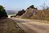 Bridgeport Hill-Hydro OK 66 Segment |
March 3, 2004 (#04000129) |
State Highway 66 from Hydro east to a spur of U.S. Route 281 35°32′29″N 98°24′43″W |
Hydro | Extends into Caddo County |
| 4 | Canadian County Jail and Stable |  Canadian County Jail and Stable |
November 14, 1995 (#85002790) |
300 S. Evans 35°32′07″N 97°57′19″W |
El Reno | |
| 5 | Carnegie Library | 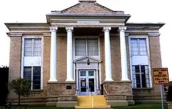 Carnegie Library |
August 29, 1980 (#80003257) |
215 E. Wade St. 35°31′53″N 97°57′05″W |
El Reno | |
| 6 | Czech Hall | 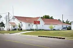 Czech Hall |
November 25, 1980 (#80003258) |
South of Yukon 35°28′07″N 97°44′33″W |
Yukon | |
| 7 | Darlington Agency Site | 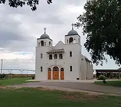 Darlington Agency Site |
August 14, 1973 (#73001557) |
About 6 miles (9.7 km) northwest of El Reno 35°34′31″N 98°00′32″W |
El Reno | |
| 8 | El Reno High School | 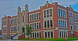 El Reno High School |
March 3, 2000 (#00000179) |
407 S. Choctaw 35°31′48″N 97°57′14″W |
El Reno | |
| 9 | El Reno Hotel | 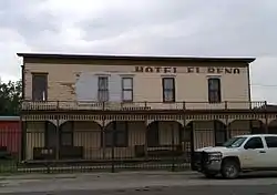 El Reno Hotel |
March 21, 1979 (#79001988) |
300 S. Choctaw St. 35°31′52″N 97°57′17″W |
El Reno | |
| 10 | El Reno Municipal Swimming Pool Bath House | 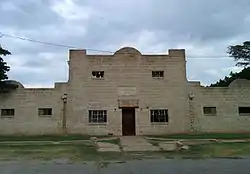 El Reno Municipal Swimming Pool Bath House |
March 30, 2000 (#00000178) |
715 S. Morrison 35°31′32″N 97°57′53″W |
El Reno | |
| 11 | Fort Reno |  Fort Reno |
June 22, 1970 (#70000529) |
3 miles (4.8 km) west and 2 miles (3.2 km) north of El Reno 35°33′42″N 98°02′06″W |
El Reno | |
| 12 | William I. and Magdalen M. Goff House | 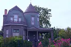 William I. and Magdalen M. Goff House |
September 8, 1988 (#88001317) |
506 S. Evans 35°31′46″N 97°57′21″W |
El Reno | |
| 13 | Jackson Conoco Service Station | Jackson Conoco Service Station |
March 2, 2004 (#04000132) |
301 S. Choctaw, (121 W. Wade) 35°31′53″N 97°57′15″W |
El Reno | |
| 14 | Henry Lassen House | 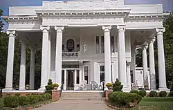 Henry Lassen House |
September 4, 2008 (#08000852) |
605 S. Hoff 35°31′41″N 97°56′57″W |
El Reno | |
| 15 | McGranahan Portion of the Chisholm Trail Roadbed | June 14, 2013 (#13000391) |
Address Restricted |
Yukon | ||
| 16 | Meloy House | 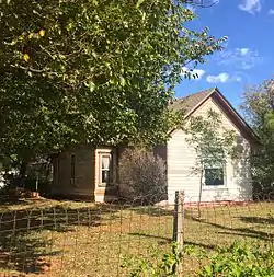 Meloy House |
September 10, 2014 (#14000592) |
131 W. Carson Dr. 35°22′53″N 97°43′32″W |
Mustang | |
| 17 | Mennoville Mennonite Church | 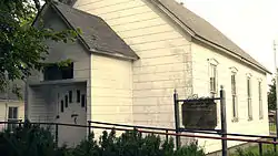 Mennoville Mennonite Church |
October 4, 1979 (#79001989) |
North of El Reno on U.S. Route 81 35°38′20″N 97°57′33″W |
El Reno | |
| 18 | Mulvey Mercantile | 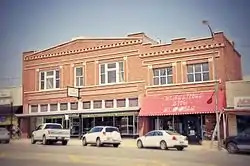 Mulvey Mercantile |
September 20, 1982 (#82003670) |
425 W. Main 35°30′13″N 97°44′36″W |
Yukon | |
| 19 | Red Cross Canteen | 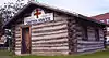 Red Cross Canteen |
September 5, 1975 (#75001560) |
Rock Island Depot 35°31′51″N 97°57′30″W |
El Reno | |
| 20 | Richardson Building | 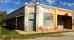 Richardson Building |
October 6, 1983 (#83004164) |
Northeast of Main and Division 35°23′11″N 97°56′02″W |
Union City | |
| 21 | Rock Island Depot |  Rock Island Depot |
March 7, 1983 (#83002078) |
400 W. Wade St. 35°31′52″N 97°57′31″W |
El Reno | |
| 22 | Southern Hotel | 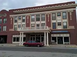 Southern Hotel |
August 2, 1978 (#78002220) |
319 S. Grand St. 35°31′50″N 97°57′27″W |
El Reno | |
| 23 | West Point Christian Church | 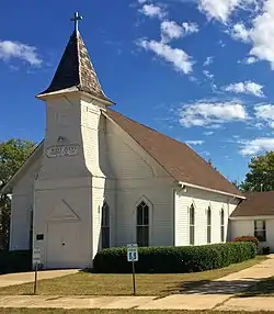 West Point Christian Church |
September 2, 1983 (#83002079) |
Southwest of Yukon 35°26′57″N 97°47′40″W |
Yukon | |
| 24 | Yukon Public Library | 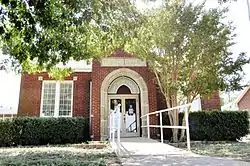 Yukon Public Library |
February 2, 1984 (#84002977) |
512 Elm St. 35°30′24″N 97°45′02″W |
Yukon |
See also
Wikimedia Commons has media related to National Register of Historic Places in Canadian County, Oklahoma.
References
- The latitude and longitude information provided in this table was derived originally from the National Register Information System, which has been found to be fairly accurate for about 99% of listings. Some locations in this table may have been corrected to current GPS standards.
- National Park Service, United States Department of the Interior, "National Register of Historic Places: Weekly List Actions", retrieved October 20, 2023.
- Numbers represent an alphabetical ordering by significant words. Various colorings, defined here, differentiate National Historic Landmarks and historic districts from other NRHP buildings, structures, sites or objects.
- "National Register Information System". National Register of Historic Places. National Park Service. March 13, 2009.
- The eight-digit number below each date is the number assigned to each location in the National Register Information System database, which can be viewed by clicking the number.
| Topics | |
|---|---|
| Lists by state |
|
| Lists by insular areas | |
| Lists by associated state | |
| Other areas | |
| Related | |
This article is issued from Wikipedia. The text is licensed under Creative Commons - Attribution - Sharealike. Additional terms may apply for the media files.