National Register of Historic Places listings in Crook County, Wyoming
This is a list of the National Register of Historic Places listings in Crook County, Wyoming.
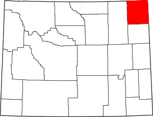
Location of Crook County in Wyoming
This is intended to be a complete list of the properties and districts on the National Register of Historic Places in Crook County, Wyoming, United States. The locations of National Register properties and districts for which the latitude and longitude coordinates are included below, may be seen in a map.[1]
There are 13 properties and districts listed on the National Register in the county.
This National Park Service list is complete through NPS recent listings posted October 20, 2023.[2]
| Albany - Big Horn - Campbell - Carbon - Converse - Crook - Fremont - Goshen - Hot Springs - Johnson - Laramie - Lincoln - Natrona - Niobrara - Park - Platte - Sheridan - Sublette - Sweetwater - Teton - Uinta - Washakie - Weston |
Current listings
| [3] | Name on the Register | Image | Date listed[4] | Location | City or town | Description |
|---|---|---|---|---|---|---|
| 1 | Arch Creek Petroglyphs (48CK41) |  Arch Creek Petroglyphs (48CK41) |
December 4, 1986 (#86003458) |
Address restricted[5] |
Moorcroft | |
| 2 | DXN Bridge over Missouri River |  DXN Bridge over Missouri River |
February 22, 1985 (#85000419) |
Crook County Road 18-200 44°58′59″N 104°29′39″W |
Hulett | |
| 3 | Entrance Road-Devils Tower National Monument | 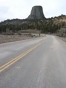 Entrance Road-Devils Tower National Monument |
July 24, 2000 (#00000854) |
Devils Tower National Monument 44°35′14″N 104°42′52″W |
Devils Tower | |
| 4 | Entrance Station-Devils Tower National Monument | 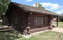 Entrance Station-Devils Tower National Monument |
July 24, 2000 (#00000853) |
Devils Tower National Monument 44°35′22″N 104°42′02″W |
Devils Tower | 1941 park building noted for its exemplary NPS Rustic architecture, and for its associations with the New Deal and the early development and management of the national monument.[6] |
| 5 | Inyan Kara Mountain | 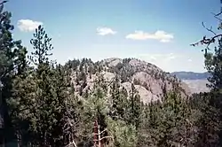 Inyan Kara Mountain |
April 24, 1973 (#73001929) |
About 15 mi (24 km) south of Sundance in Black Hills National Forest 44°12′48″N 104°21′00″W |
Sundance vicinity | Outlying peak of the Black Hills, figuring in the Lakota people's culture and network of signalling sites, and a landmark to White explorers and military expeditions.[7] |
| 6 | McKean Archeological Site (48CK7) | 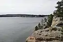 McKean Archeological Site (48CK7) |
April 1, 1991 (#91000326) |
Within the Keyhole Reservoir[8] 44°21′55″N 104°50′20″W |
Moorcroft | Extensive and well-stratified site showing 5,000 years of Native American use; further significant as a key type site for Middle Plains Archaic period projectile points and in the professional development of Northern Plains archaeology.[9] |
| 7 | Old Headquarters Area Historic District | 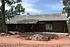 Old Headquarters Area Historic District |
July 20, 2000 (#00000852) |
Devils Tower National Monument 44°35′26″N 104°43′15″W |
Devils Tower | Three buildings constructed by the Civilian Conservation Corps 1931–37, noted for their association with the New Deal, the development of the first U.S. National Monument, and for their exemplary NPS Rustic architecture.[10] |
| 8 | Ranch A |  Ranch A |
March 17, 1997 (#97000227) |
501 Sand Creek Rd. 44°29′24″N 104°06′38″W |
Beulah | Vacation estate of newspaper publisher Moses Annenberg with 13 contributing properties built 1932–1935; noted as some of the finest rustic architecture in Wyoming.[11] Now an event center.[12] |
| 9 | Sundance School | 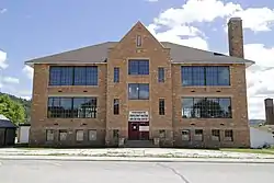 Sundance School |
December 2, 1985 (#85003099) |
108 N. 4th St. 44°24′22″N 104°22′40″W |
Sundance | Sundance's most architecturally prominent public building and a rare local use of locally quarried stone. Also a key venue in the development of the region's youth 1923–1971.[13] Now the Crook County Museum and Art Gallery.[14] |
| 10 | Sundance State Bank | 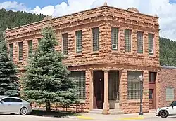 Sundance State Bank |
March 23, 1984 (#84003660) |
301 Main St. 44°24′22″N 104°22′47″W |
Sundance | 1914 bank noted for its distinctive transitional architecture and its association with a speculative boom in the Wyoming banking industry due to inflated agricultural prices during World War I.[15] |
| 11 | Tower Ladder-Devils Tower National Monument | 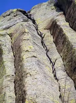 Tower Ladder-Devils Tower National Monument |
July 24, 2000 (#00000855) |
Devils Tower National Monument 44°35′23″N 104°42′50″W |
Devils Tower | Surviving 170-foot (52 m) section of an 1893 ladder built for the first known ascent of Devils Tower and used in numerous subsequent attempts up to 1927, which helped galvanize recreational climbing of the tower and local support for its protection.[16] |
| 12 | Vore Buffalo Jump | 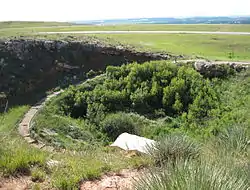 Vore Buffalo Jump |
April 11, 1973 (#73001930) |
369 Old U.S. Route 14[17] 44°32′09″N 104°09′24″W |
Beulah vicinity | 40-foot-deep (12 m) sinkhole used as a buffalo jump roughly 1300–1700, yielding well-preserved bison bones and projectile points.[18] Now a visitor attraction.[19] |
| 13 | Wyoming Mercantile | 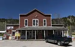 Wyoming Mercantile |
April 16, 1991 (#91000435) |
3983 Wyoming Highway 24 44°38′24″N 104°10′57″W |
Aladdin | One of Wyoming's only intact vernacular 19th-century general stores—built in 1896—and the long-serving nucleus of the tiny community of Aladdin.[20] |
See also
Wikimedia Commons has media related to National Register of Historic Places in Crook County, Wyoming.
References
- The latitude and longitude information provided in this table was derived originally from the National Register Information System, which has been found to be fairly accurate for about 99% of listings. Some locations in this table may have been corrected to current GPS standards.
- National Park Service, United States Department of the Interior, "National Register of Historic Places: Weekly List Actions", retrieved October 20, 2023.
- Numbers represent an alphabetical ordering by significant words. Various colorings, defined here, differentiate National Historic Landmarks and historic districts from other NRHP buildings, structures, sites or objects.
- The eight-digit number below each date is the number assigned to each location in the National Register Information System database, which can be viewed by clicking the number.
- Federal and state laws and practices restrict general public access to information regarding the specific location of this resource. In some cases, this is to protect archeological sites from vandalism, while in other cases it is restricted at the request of the owner. See: Knoerl, John; Miller, Diane; Shrimpton, Rebecca H. (1990), Guidelines for Restricting Information about Historic and Prehistoric Resources, National Register Bulletin, National Park Service, U.S. Department of the Interior, OCLC 20706997.
- McKoy, Kathy (2000-04-15). National Register of Historic Places Registration Form: Entrance Station. National Park Service. Retrieved 2023-09-11.
- Junge, Mark (1971-08-26). National Register of Historic Places Inventory – Nomination Form: Inyan Kara Mountain. National Park Service. Retrieved 2023-09-11.
- Mulloy, William. "The McKean Site in Northeastern Wyoming". Southwestern Journal of Anthropology 10.4 (1954): 432-460: 435.
- "McKean Archaeological Site". Wyoming State Historic Preservation Office. Retrieved 2023-09-01.
- McKoy, Kathy (2000-04-20). National Register of Historic Places Registration Form: Old Headquarters Area Historic District. National Park Service. Retrieved 2023-08-29.
- Starr, Eileen; Phyllis Guenin (May 1995). National Register of Historic Places Registration Form: Ranch A. National Park Service. Retrieved 2023-08-12.
- "Ranch A". Ranch A Restoration Foundation. 2022. Retrieved 2023-08-12.
- Gorman, Mike (1984-02-07). National Register of Historic Places Inventory—Nomination Form: Sundance State Bank. National Park Service. Retrieved 2023-08-07.
- "Crook County Museum". Sundance Chamber of Commerce. Retrieved 2023-08-12.
- Gorman, Mike (1984-02-07). National Register of Historic Places Inventory—Nomination Form: Sundance State Bank. National Park Service. Retrieved 2023-08-07.
- McKoy, Kathy (2000-04-15). National Register of Historic Places Registration Form: Tower Ladder. National Park Service. Retrieved 2023-08-07.
- Location derived from this website; the NRIS lists the site as "Address Restricted"
- "Vore Buffalo Jump". Wyoming State Historic Preservation Office. Retrieved 2023-07-20.
- "Vore Buffalo Jump". Vore Buffalo Jump Foundation. Retrieved 2023-07-20.
- Brown, Mabel (1990-04-20). National Register of Historic Places Registration Form: Wyoming Mercantile. National Park Service. Retrieved 2023-07-19.
| Topics | |
|---|---|
| Lists by state |
|
| Lists by insular areas | |
| Lists by associated state | |
| Other areas | |
| Related | |
Municipalities and communities of Crook County, Wyoming, United States | ||
|---|---|---|
| Towns | | |
| CDP | ||
| Unincorporated communities | ||
This article is issued from Wikipedia. The text is licensed under Creative Commons - Attribution - Sharealike. Additional terms may apply for the media files.