National Register of Historic Places listings in Eddy County, New Mexico
This is a list of the National Register of Historic Places listings in Eddy County, New Mexico.

This is intended to be a complete list of the properties and districts on the National Register of Historic Places in Eddy County, New Mexico, United States. Latitude and longitude coordinates are provided for many National Register properties and districts; these locations may be seen together in a map.[1]
There are 32 properties and districts listed on the National Register in the county, including 1 National Historic Landmark. All of the places within the county on the National Register are also listed on the State Register of Cultural Properties.
This National Park Service list is complete through NPS recent listings posted October 20, 2023.[2]
| Bernalillo – Catron – Chaves – Cibola – Colfax – Curry – De Baca – Doña Ana – Eddy – Grant – Guadalupe – Harding – Hidalgo – Lea – Lincoln – Los Alamos – Luna – McKinley – Mora – Otero – Quay – Rio Arriba – Roosevelt – San Juan – San Miguel – Sandoval – Santa Fe – Sierra – Socorro – Taos – Torrance – Union – Valencia |
Current listings
| [3] | Name on the Register[4] | Image | Date listed[5] | Location | City or town | Description |
|---|---|---|---|---|---|---|
| 1 | Abo Elementary School and Fallout Shelter | 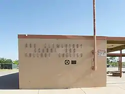 Abo Elementary School and Fallout Shelter |
September 29, 1999 (#99001171) |
1802 Center Ave. 32°49′57″N 104°25′09″W |
Artesia | |
| 2 | John Acord House |  John Acord House |
March 2, 1984 (#84002891) |
W. Main St. 32°50′31″N 104°24′21″W |
Artesia | |
| 3 | Archeological Site No. AR 03-08-03-195 | November 24, 1995 (#95001319) |
Address Restricted |
Queen | ||
| 4 | Archeological Site No. AR-03-08-03-232 | November 24, 1995 (#95001320) |
Address Restricted |
Queen | ||
| 5 | Artesia Residential Historic District | September 25, 2014 (#09001267) |
Roughly bounded by W. Main St. on the north, W. Missouri Ave. on the south, S. 2nd St. on the east, and S. 10th St. on the west 32°50′24″N 104°24′15″W |
Artesia | ||
| 6 | Willie D. Atkeson House | 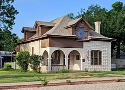 Willie D. Atkeson House |
March 2, 1984 (#84002894) |
303 W. Grand Ave. 32°50′19″N 104°23′52″W |
Artesia | |
| 7 | Baskin Building | 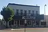 Baskin Building |
July 18, 1990 (#90000599) |
332 W. Main St. 32°50′33″N 104°24′01″W |
Artesia | |
| 8 | William Baskin House | 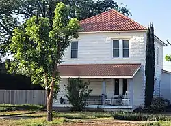 William Baskin House |
March 2, 1984 (#84002898) |
811 W. Quay Ave. 32°50′27″N 104°24′24″W |
Artesia | |
| 9 | Carlsbad Irrigation District | .jpg.webp) Carlsbad Irrigation District |
October 15, 1966 (#66000476) |
North of Carlsbad 32°29′31″N 104°15′09″W |
Carlsbad | |
| 10 | The Caverns Historic District | 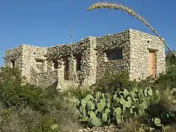 The Caverns Historic District |
August 18, 1988 (#88001173) |
End of State Road 7; also 7 miles west of U.S. Routes 62/180 at the end of State Route 7 32°10′37″N 104°26′31″W |
Carlsbad | Carlsbad Caverns National Park; Second set of boundaries represents a boundary increase of January 8, 2014 |
| 11 | Dam-Sitting Bull Falls Recreation Area | December 23, 1993 (#93001420) |
Sitting Bull Falls in the Lincoln National Forest 32°14′42″N 104°41′42″W |
Carlsbad | ||
| 12 | Dark Canyon Apache Rancheria-Military Battle Site | February 15, 2002 (#02000083) |
Address Restricted |
Queen | ||
| 13 | First National Bank of Eddy | 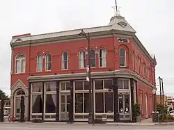 First National Bank of Eddy |
December 12, 1976 (#76001196) |
303 W. Fox St. 32°25′08″N 104°13′44″W |
Carlsbad | |
| 14 | Edward R. Gesler House | 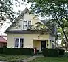 Edward R. Gesler House |
March 2, 1984 (#84002924) |
411 W. Missouri Ave. 32°50′15″N 104°24′06″W |
Artesia | |
| 15 | Group Picnic Shelter-Sitting Bull Falls Recreation Area | December 23, 1993 (#93001419) |
Sitting Bull Falls in the Lincoln National Forest 32°14′45″N 104°41′47″W |
Carlsbad | ||
| 16 | Hodges-Runyan-Brainard House |  Hodges-Runyan-Brainard House |
March 2, 1984 (#84002925) |
504 W. Quay Ave. 32°50′29″N 104°24′09″W |
Artesia | |
| 17 | Hodges-Sipple House | 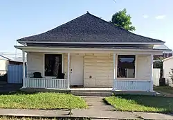 Hodges-Sipple House |
March 2, 1984 (#84002926) |
804 W. Missouri Ave. 32°50′17″N 104°24′22″W |
Artesia | |
| 18 | LA 157206-White Oaks Pictograph Site | November 22, 2011 (#11000829) |
Address Restricted |
Queen | ||
| 19 | LA 158783-Ambush Site | November 22, 2011 (#11000825) |
Address Restricted |
Queen | ||
| 20 | LA 162411-Lost Again Shelter | November 22, 2011 (#11000828) |
Address Restricted |
Queen | ||
| 21 | LA 64908-Ambush Two Hands Shelter | November 22, 2011 (#11000826) |
Address Restricted |
Queen | ||
| 22 | LA 71921-Horse Well Shelters | November 22, 2011 (#11000827) |
Address Restricted |
Queen | ||
| 23 | Last Chance Canyon Apache-Cavalry Battle Site | October 24, 2000 (#00001230) |
Address Restricted |
Queen | ||
| 24 | F. L. Lukins House | 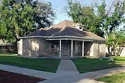 F. L. Lukins House |
March 2, 1984 (#84002928) |
801 W. Richardson Ave. 32°50′23″N 104°24′21″W |
Artesia | |
| 25 | Mauldin-Hall House | 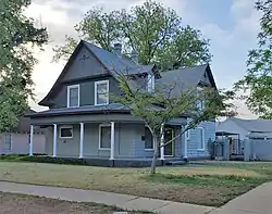 Mauldin-Hall House |
March 2, 1984 (#84002930) |
501 S. Roselawn Ave. 32°50′16″N 104°23′56″W |
Artesia | |
| 26 | Moore-Ward Cobblestone House |  Moore-Ward Cobblestone House |
February 16, 1984 (#84002932) |
505 W. Richardson Ave. 32°50′23″N 104°24′09″W |
Artesia | |
| 27 | Painted Grotto | 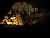 Painted Grotto |
March 8, 1977 (#77000159) |
Address Restricted |
Carlsbad | Carlsbad Caverns National Park |
| 28 | Picnic Shelter-Sitting Bull Falls Recreation Area | December 23, 1993 (#93001418) |
Sitting Bull Falls in the Lincoln National Forest 32°14′42″N 104°41′44″W |
Carlsbad | ||
| 29 | Rattlesnake Springs Historic District |  Rattlesnake Springs Historic District |
July 14, 1988 (#88001130) |
West of U.S. Routes 62/180 off County Road 418 32°06′36″N 104°28′04″W |
Carlsbad | Carlsbad Caverns National Park |
| 30 | Sallie Chisum Robert House |  Sallie Chisum Robert House |
March 2, 1984 (#84002939) |
801 W. Texas St. 32°50′35″N 104°24′21″W |
Artesia | |
| 31 | Dr. Robert M. Ross House | March 2, 1984 (#84002936) |
1002 S. Roselawn Ave. 32°49′53″N 104°23′58″W |
Artesia | ||
| 32 | Rober Weems and Mary E. Tansill House | October 10, 2002 (#02001111) |
1612 N. Guadalupe St. 32°26′57″N 104°13′53″W |
Carlsbad |
Former listing
| [3] | Name on the Register | Image | Date listed | Date removed | Location | City or town | Description |
|---|---|---|---|---|---|---|---|
| 1 | Sipple-Ward Building | October 4, 1991 (#91001503) | September 6, 2007 | 331 West Main Street |
Artesia | Destroyed by fire on October 31, 2000.[6] |
See also
References
- The latitude and longitude information provided in this table was derived originally from the National Register Information System, which has been found to be fairly accurate for about 99% of listings. Some locations in this table may have been corrected to current GPS standards.
- National Park Service, United States Department of the Interior, "National Register of Historic Places: Weekly List Actions", retrieved October 20, 2023.
- Numbers represent an alphabetical ordering by significant words. Various colorings, defined here, differentiate National Historic Landmarks and historic districts from other NRHP buildings, structures, sites or objects.
- "National Register Information System". National Register of Historic Places. National Park Service. July 9, 2010.
- The eight-digit number below each date is the number assigned to each location in the National Register Information System database, which can be viewed by clicking the number.
- "Fire destroys historic building". Carlsbad Current-Argus. November 1, 2000. p. 1. Retrieved August 7, 2022 – via Newspapers.com.
| Topics | |
|---|---|
| Lists by state |
|
| Lists by insular areas | |
| Lists by associated state | |
| Other areas | |
| Related | |
Municipalities and communities of Eddy County, New Mexico, United States | ||
|---|---|---|
| Cities | Map of New Mexico highlighting Eddy County | |
| Villages | ||
| CDPs | ||
| Unincorporated communities | ||