National Register of Historic Places listings in Edmonson County, Kentucky
This is a list of the National Register of Historic Places listings in Edmonson County, Kentucky.
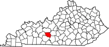
Location of Edmonson County in Kentucky
This is intended to be a complete list of the properties and districts on the National Register of Historic Places in Edmonson County, Kentucky, United States. The locations of National Register properties and districts for which the latitude and longitude coordinates are included below, may be seen in a map.[1]
There are 24 properties and districts listed on the National Register in the county.
This National Park Service list is complete through NPS recent listings posted October 20, 2023.[2]
Current listings
| [3] | Name on the Register | Image | Date listed[4] | Location | City or town | Description |
|---|---|---|---|---|---|---|
| 1 | Asphalt Rock Pictographs (15ED24) | September 8, 1989 (#89001185) |
Address Restricted |
Asphalt | ||
| 2 | Bransford Spring Pumphouse | 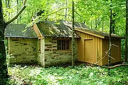 Bransford Spring Pumphouse |
May 8, 1991 (#91000493) |
Mammoth Cave National Park 37°12′05″N 86°04′37″W |
Mammoth Cave | |
| 3 | Chalybeate Springs Hotel Springhouse | March 5, 2018 (#100002154) |
2327 Chalybeate Rd. 37°07′35″N 86°14′06″W |
Smiths Grove vicinity | ||
| 4 | Colossal Cavern Entrance | 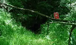 Colossal Cavern Entrance |
May 8, 1991 (#91000491) |
Mammoth Cave National Park 37°11′17″N 86°04′24″W |
Mammoth Cave | |
| 5 | Crystal Cave District | 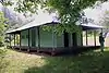 Crystal Cave District |
May 8, 1991 (#91000500) |
Mammoth Cave National Park 37°12′40″N 86°03′17″W |
Mammoth Cave | |
| 6 | Dismal Rock Shelter Petroglyphs (15ED15) | September 8, 1989 (#89001184) |
Address Restricted |
Sweeden | ||
| 7 | William Ford House | 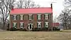 William Ford House |
November 28, 1980 (#80001506) |
South of Brownsville on U.S. Route 31W 37°05′40″N 86°12′33″W |
Brownsville | |
| 8 | Good Spring Baptist Church and Cemetery | 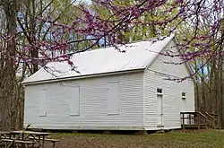 Good Spring Baptist Church and Cemetery |
May 8, 1991 (#91000498) |
Mammoth Cave National Park 37°12′32″N 86°08′53″W |
Mammoth Cave | |
| 9 | Great Onyx Cave Entrance | 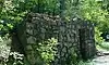 Great Onyx Cave Entrance |
May 8, 1991 (#91000490) |
Mammoth Cave National Park 37°13′08″N 86°04′41″W |
Mammoth Cave | |
| 10 | Hercules and Coach No. 2 | 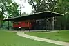 Hercules and Coach No. 2 |
October 10, 1975 (#75000160) |
Off Kentucky Route 70 in Mammoth Cave National Park 37°11′02″N 86°05′56″W |
Mammoth Cave | |
| 11 | Joppa Baptist Church and Cemetery | 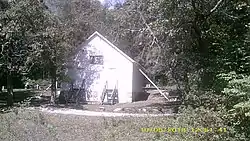 Joppa Baptist Church and Cemetery |
May 8, 1991 (#91000496) |
Mammoth Cave National Park 37°09′46″N 86°08′06″W |
Mammoth Cave | |
| 12 | Maintenance Area District | 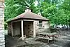 Maintenance Area District |
May 8, 1991 (#91000501) |
Mammoth Cave National Park 37°10′49″N 86°05′09″W |
Mammoth Cave | |
| 13 | Mammoth Cave Baptist Church and Cemetery | 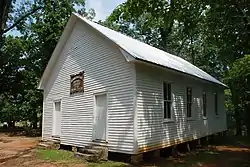 Mammoth Cave Baptist Church and Cemetery |
May 8, 1991 (#91000497) |
Mammoth Cave National Park 37°11′52″N 86°04′23″W |
Mammoth Cave | |
| 14 | Mammoth Cave Historic District | 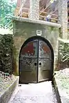 Mammoth Cave Historic District |
May 8, 1991 (#91000503) |
Mammoth Cave National Park 37°10′10″N 86°05′00″W |
Mammoth Cave | |
| 15 | Maple Springs Ranger Station | May 8, 1991 (#91000494) |
Mammoth Cave National Park 37°12′26″N 86°07′56″W |
Mammoth Cave | ||
| 16 | Mill Hole Farm | May 22, 1978 (#78001311) |
West of Park City off U.S. Route 31W 37°06′38″N 86°06′50″W |
Park City | ||
| 17 | Mitchell-Estes Farmstead | 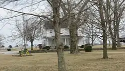 Mitchell-Estes Farmstead |
January 11, 1996 (#95001528) |
1706 Upper Smiths Grove Rd. 37°04′36″N 86°11′29″W |
Smiths Grove | Extends into Warren County |
| 18 | Old Guide Cemetery |  Old Guide Cemetery |
May 8, 1991 (#91000499) |
Mammoth Cave National Park 37°11′12″N 86°06′20″W |
Mammoth Cave | |
| 19 | Reed-Dossey House | 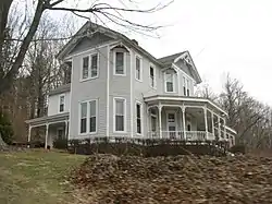 Reed-Dossey House |
October 16, 1986 (#86002866) |
Upper Main Cross and Jefferson Sts. 37°11′34″N 86°16′11″W |
Brownsville | c.1890 house which served as a boarding house, and is very well-preserved |
| 20 | Residential Area District | 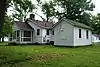 Residential Area District |
May 8, 1991 (#91000502) |
Mammoth Cave National Park 37°11′01″N 86°05′21″W |
Mammoth Cave | |
| 21 | Salts Cave Archeological Site | May 15, 1979 (#79000278) |
Address restricted[5] |
Munfordville | ||
| 22 | Superintendent's House | May 8, 1991 (#91000495) |
Mammoth Cave National Park 37°11′03″N 86°05′11″W |
Mammoth Cave | ||
| 23 | Three Springs Pumphouse | 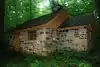 Three Springs Pumphouse |
May 8, 1991 (#91000492) |
Mammoth Cave National Park 37°11′45″N 86°04′59″W |
Mammoth Cave | |
| 24 | Mathias Willis Store House | January 8, 1987 (#87000172) |
Cummins Rd. 37°10′44″N 86°21′34″W |
Windyville |
See also
Wikimedia Commons has media related to National Register of Historic Places in Edmonson County, Kentucky.
References
- The latitude and longitude information provided in this table was derived originally from the National Register Information System, which has been found to be fairly accurate for about 99% of listings. Some locations in this table may have been corrected to current GPS standards.
- National Park Service, United States Department of the Interior, "National Register of Historic Places: Weekly List Actions", retrieved October 20, 2023.
- Numbers represent an alphabetical ordering by significant words. Various colorings, defined here, differentiate National Historic Landmarks and historic districts from other NRHP buildings, structures, sites or objects.
- The eight-digit number below each date is the number assigned to each location in the National Register Information System database, which can be viewed by clicking the number.
- Federal and state laws and practices restrict general public access to information regarding the specific location of this resource. In some cases, this is to protect archeological sites from vandalism, while in other cases it is restricted at the request of the owner. See: Knoerl, John; Miller, Diane; Shrimpton, Rebecca H. (1990), Guidelines for Restricting Information about Historic and Prehistoric Resources, National Register Bulletin, National Park Service, U.S. Department of the Interior, OCLC 20706997.
| Topics | |
|---|---|
| Lists by state |
|
| Lists by insular areas | |
| Lists by associated state | |
| Other areas | |
| Related | |
Municipalities and communities of Edmonson County, Kentucky, United States | ||
|---|---|---|
| City | Location of Edmonson County, Kentucky | |
| Unincorporated communities | ||
| Ghost towns |
| |
| Footnotes | ‡This populated place also has portions in an adjacent county or counties | |
This article is issued from Wikipedia. The text is licensed under Creative Commons - Attribution - Sharealike. Additional terms may apply for the media files.