National Register of Historic Places listings in Geary County, Kansas
This is a list of the National Register of Historic Places listings in Geary County, Kansas.
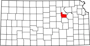
Location of Geary County in Kansas
This is intended to be a complete list of the properties and districts on the National Register of Historic Places in Geary County, Kansas, United States. The locations of National Register properties and districts for which the latitude and longitude coordinates are included below, may be seen in a map.[1]
There are 16 properties and districts listed on the National Register in the county.
This National Park Service list is complete through NPS recent listings posted October 20, 2023.[2]
Current listings
| [3] | Name on the Register[4] | Image | Date listed[5] | Location | City or town | Description |
|---|---|---|---|---|---|---|
| 1 | Bartell House | 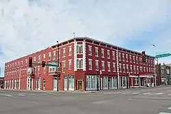 Bartell House |
December 1, 1980 (#80001466) |
6th and Washington Sts. 39°01′42″N 96°49′47″W |
Junction City | |
| 2 | Bogan Archeological Site | May 17, 1973 (#73000756) |
Address restricted |
Junction City | ||
| 3 | George T. Brown House | 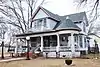 George T. Brown House |
December 27, 2006 (#06001167) |
222 S. Jefferson St. 39°01′16″N 96°49′55″W |
Junction City | |
| 4 | Conroe Bridge | 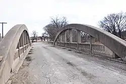 Conroe Bridge |
March 10, 1983 (#83000427) |
East of Junction City 39°02′56″N 96°43′51″W |
Junction City | |
| 5 | James Dixon House | 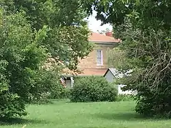 James Dixon House |
April 1, 1998 (#98000265) |
8715 Old Highway 77 39°06′10″N 96°51′00″W |
Milford | Italianate, limestone house completed in 1880. Known also as Military View Farm, it overlooks Fort Dixon. |
| 6 | Elliott Village Site | December 8, 1978 (#78001280) |
Right bank of McDowell Creek south of McDowell Creek Road, east of Junction City[6] 39°02′08″N 96°36′52″W |
Junction City | ||
| 7 | First Presbyterian Church of Junction City | 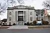 First Presbyterian Church of Junction City |
October 4, 2021 (#100007028) |
113 West 5th St. 39°01′38″N 96°49′49″W |
Junction City | |
| 8 | First Territorial Capitol | 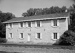 First Territorial Capitol |
December 2, 1970 (#70000249) |
Along K-18 on the Fort Riley Military Reservation 39°05′05″N 96°45′42″W |
Fort Riley | |
| 9 | Grand Army of the Republic (GAR) Memorial Arch | 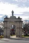 Grand Army of the Republic (GAR) Memorial Arch |
January 11, 2017 (#100000512) |
500 N. Washington St. 39°01′41″N 96°49′47″W |
Junction City | |
| 10 | Jackson-McConnell House | 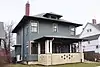 Jackson-McConnell House |
April 16, 2012 (#12000204) |
228 W. 5th St. 39°01′38″N 96°49′55″W |
Junction City | |
| 11 | Junction City Downtown Historic District | 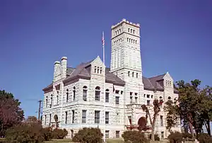 Junction City Downtown Historic District |
July 19, 2006 (#06000623) |
Roughly both sides of Washington Ave., from 6th to 9th Sts. 39°01′55″N 96°49′47″W |
Junction City | |
| 12 | Leithoff-Powers Ranch Historic District | 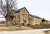 Leithoff-Powers Ranch Historic District |
July 28, 1995 (#95000946) |
K-57 southeast of Junction City 38°59′11″N 96°42′59″W |
Junction City | |
| 13 | Lyon Creek Rainbow Arch | 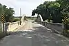 Lyon Creek Rainbow Arch |
December 22, 2020 (#100005949) |
100 ft. southwest from the jct. of Lyon Creek Rd. & Hwy. K-157 Spur 38°53′05″N 96°54′36″W |
Wreford | |
| 14 | Main Post Area, Fort Riley | _ELEVATION%252C_LOOKING_NORTH-NORTHEAST._-_Fort_Riley%252C_Building_No._24%252C_24_Sheridan_Avenue%252C_Riley%252C_Riley_County%252C_KS_HABS_KANS%252C81-FORIL%252C2-A-1.tif.jpg.webp) Main Post Area, Fort Riley |
May 1, 1974 (#74000837) |
Northeast of Junction City on K-18 39°04′07″N 96°46′53″W |
Fort Riley | |
| 15 | Old Junction City High School | 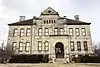 Old Junction City High School |
April 24, 1981 (#81000278) |
Adams and 6th Sts. 39°01′40″N 96°50′01″W |
Junction City | |
| 16 | Old Katy Bridge | 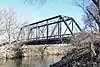 Old Katy Bridge |
May 9, 2003 (#03000370) |
Otter Creek Rd., 0.4 miles (0.64 km) south of its intersection with Lyons Creek Rd. and 0.5 miles (0.80 km) southeast of Wreford 38°57′18″N 96°50′46″W |
Wreford | |
| 17 | Christian Wetzel Cabin | 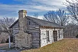 Christian Wetzel Cabin |
October 15, 1973 (#73000757) |
Intersection of Spring Valley Rd and Highway K-18 39°01′46″N 96°52′19″W |
Junction City |
See also
Wikimedia Commons has media related to National Register of Historic Places in Geary County, Kansas.
References
- The latitude and longitude information provided in this table was derived originally from the National Register Information System, which has been found to be fairly accurate for about 99% of listings. Some locations in this table may have been corrected to current GPS standards.
- National Park Service, United States Department of the Interior, "National Register of Historic Places: Weekly List Actions", retrieved October 20, 2023.
- Numbers represent an alphabetical ordering by significant words. Various colorings, defined here, differentiate National Historic Landmarks and historic districts from other NRHP buildings, structures, sites or objects.
- "National Register Information System". National Register of Historic Places. National Park Service. March 13, 2009.
- The eight-digit number below each date is the number assigned to each location in the National Register Information System database, which can be viewed by clicking the number.
- O'Brien, Patricia J., et al. "The Elliott Site (14GE303): A Preliminary Report". Plains Anthropologist 18.59 (1973): 54-72: 56.
| Topics |  | |
|---|---|---|
| Lists by county |
| |
| Other lists |
| |
| ||
Municipalities and communities of Geary County, Kansas, United States | ||
|---|---|---|
| Cities | Map of Kansas highlighting Geary County | |
| Unincorporated communities | ||
| Ghost towns | ||
| Townships | ||
| Footnotes | †This community is designated a Census-Designated Place (CDP) by the United States Census Bureau. ‡This community also has portions in an adjacent county or counties. | |
This article is issued from Wikipedia. The text is licensed under Creative Commons - Attribution - Sharealike. Additional terms may apply for the media files.