National Register of Historic Places listings in Lyon County, Kansas
This is a list of the National Register of Historic Places listings in Lyon County, Kansas.

Location of Lyon County in Kansas
This is intended to be a complete list of the properties on the National Register of Historic Places in Lyon County, Kansas, United States. The locations of National Register properties for which the latitude and longitude coordinates are included below, may be seen in a map.[1]
There are 19 properties listed on the National Register in the county.
This National Park Service list is complete through NPS recent listings posted October 20, 2023.[2]
Current listings
| [3] | Name on the Register[4] | Image | Date listed[5] | Location | City or town | Description |
|---|---|---|---|---|---|---|
| 1 | Anderson Carnegie Memorial Library | 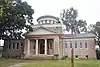 Anderson Carnegie Memorial Library |
June 25, 1987 (#87000958) |
1220 C of E Drive, former College of Emporia 38°24′46″N 96°11′38″W |
Emporia | [6] |
| 2 | Col. H.C. and Susan Cross House | 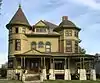 Col. H.C. and Susan Cross House |
August 4, 2011 (#11000505) |
526 Union St. 38°24′17″N 96°10′34″W |
Emporia | |
| 3 | Emporia Downtown Historic District | 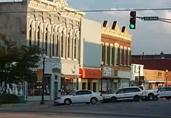 Emporia Downtown Historic District |
May 1, 2012 (#12000249) |
Generally bounded by 10th & 3rd Aves., Mechanic & Merchant Sts. 38°24′21″N 96°10′49″W |
Emporia | |
| 4 | Warren Wesley Finney House |  Warren Wesley Finney House |
May 7, 1992 (#92000470) |
927 State St. 38°24′35″N 96°11′07″W |
Emporia | |
| 5 | Granada Theater | 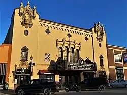 Granada Theater |
April 4, 1985 (#85000693) |
809 Commercial 38°24′28″N 96°10′48″W |
Emporia | |
| 6 | Harris Bridge | 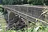 Harris Bridge |
July 2, 1985 (#85001434) |
3 miles (4.8 km) north and 4 miles (6.4 km) west of Americus 38°33′01″N 96°20′06″W |
Americus | |
| 7 | Harris-Borman House | 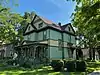 Harris-Borman House |
April 28, 1992 (#92000431) |
827 Mechanic 38°24′31″N 96°10′45″W |
Emporia | |
| 8 | Hartford Collegiate Institute | 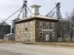 Hartford Collegiate Institute |
February 23, 1972 (#72000512) |
Southwestern corner of College and Plumb Aves. 38°18′32″N 95°57′25″W |
Hartford | |
| 9 | Richard Howe House | 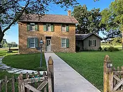 Richard Howe House |
July 17, 1986 (#86001701) |
315 E. Logan Ave. 38°23′29″N 96°10′28″W |
Emporia | |
| 10 | Keebler-Stone House | 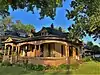 Keebler-Stone House |
April 28, 1992 (#92000387) |
831 Constitution St. 38°24′27″N 96°10′57″W |
Emporia | |
| 11 | Kress Building | 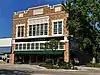 Kress Building |
August 25, 1983 (#83000431) |
702 Commercial St. 38°24′23″N 96°10′47″W |
Emporia | |
| 12 | Walt Mason House | 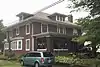 Walt Mason House |
April 30, 1992 (#92000446) |
606 W. 12th Ave. 38°24′45″N 96°11′20″W |
Emporia | |
| 13 | Snowden S. Mouse Service Station and Tourist Home | 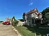 Snowden S. Mouse Service Station and Tourist Home |
June 29, 2018 (#100002627) |
413 E 6th Ave. & 526 N Exchange St. 38°24′18″N 96°10′29″W |
Emporia | |
| 14 | Old Emporia Public Library | 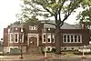 Old Emporia Public Library |
November 2, 1981 (#81000279) |
118 E. 6th St. 38°24′19″N 96°10′40″W |
Emporia | |
| 15 | Mrs. Preston B. Plumb House | 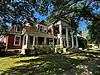 Mrs. Preston B. Plumb House |
October 4, 1984 (#84000011) |
224 E. 6th Ave. 38°24′19″N 96°10′36″W |
Emporia | |
| 16 | Rocky Ford Bridge | 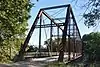 Rocky Ford Bridge |
December 22, 2020 (#100005953) |
3.5m east of Commercial St. & East 6th Ave. 38°21′57″N 96°06′54″W |
Emporia | |
| 17 | Soden's Grove Bridge | 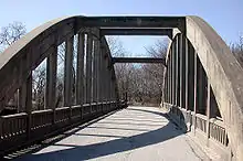 Soden's Grove Bridge |
March 10, 1983 (#83000432) |
K-57/K-99 38°23′09″N 96°10′54″W |
Emporia | |
| 18 | Hallie B. Soden House | 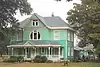 Hallie B. Soden House |
November 9, 1977 (#77000589) |
802 S. Commercial St. 38°23′17″N 96°10′45″W |
Emporia | |
| 19 | William Allen White House | 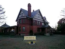 William Allen White House |
May 14, 1971 (#71000318) |
927 Exchange St. 38°24′34″N 96°10′30″W |
Emporia |
See also
Wikimedia Commons has media related to National Register of Historic Places in Lyon County, Kansas.
References
- The latitude and longitude information provided in this table was derived originally from the National Register Information System, which has been found to be fairly accurate for about 99% of listings. Some locations in this table may have been corrected to current GPS standards.
- National Park Service, United States Department of the Interior, "National Register of Historic Places: Weekly List Actions", retrieved October 20, 2023.
- Numbers represent an alphabetical ordering by significant words. Various colorings, defined here, differentiate National Historic Landmarks and historic districts from other NRHP buildings, structures, sites or objects.
- "National Register Information System". National Register of Historic Places. National Park Service. March 13, 2009.
- The eight-digit number below each date is the number assigned to each location in the National Register Information System database, which can be viewed by clicking the number.
- "An inside look at Anderson Memorial Library". Emporia Gazette. July 31, 2017. Archived from the original on December 21, 2020.
| Topics |  | |
|---|---|---|
| Lists by county |
| |
| Other lists |
| |
| ||
Municipalities and communities of Lyon County, Kansas, United States | ||
|---|---|---|
| Cities | Map of Kansas highlighting Lyon County | |
| Unincorporated communities | ||
| Townships | ||
This article is issued from Wikipedia. The text is licensed under Creative Commons - Attribution - Sharealike. Additional terms may apply for the media files.