National Register of Historic Places listings in Surry County, North Carolina
This list includes properties and districts listed on the National Register of Historic Places in Surry County, North Carolina, United States. Click the "Map of all coordinates" link to the right to view an online map of all properties and districts with latitude and longitude coordinates in the table below.[1]
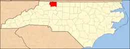
Map showing Surry County in North Carolina
Current listings
This National Park Service list is complete through NPS recent listings posted October 20, 2023.[2]
| [3] | Name on the Register | Image | Date listed[4] | Location | City or town | Description |
|---|---|---|---|---|---|---|
| 1 | Samuel Josiah Atkinson House | 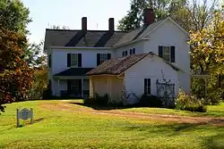 Samuel Josiah Atkinson House |
April 16, 2012 (#12000217) |
586 Atkinson Rd. 36°17′41″N 80°33′40″W |
Siloam | |
| 2 | Bank of Pilot Mountain, (Former) | 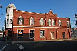 Bank of Pilot Mountain, (Former) |
December 1, 1997 (#97001497) |
100 E. Main St. 36°23′05″N 80°28′01″W |
Pilot Mountain | |
| 3 | W. F. Carter House | 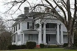 W. F. Carter House |
August 18, 1983 (#83001917) |
418 S. Main St. 36°29′48″N 80°36′17″W |
Mount Airy | |
| 4 | William Carter House | March 15, 1990 (#90000349) |
SR 1626, 0.35 miles (0.56 km) west of the junction with SR 1625 36°32′24″N 80°40′06″W |
Mount Airy | ||
| 5 | Cedar Point |  Cedar Point |
September 11, 2003 (#03000927) |
350 W. Main St. 36°14′36″N 80°51′27″W |
Elkin | |
| 6 | Country Club Estates Historic District | December 22, 2020 (#100005977) |
Includes portions of Club View Dr., Country Club Rd., Fairway Ln., and Greenhill Rd. 36°31′33″N 80°36′33″W |
Mount Airy | ||
| 7 | C. C. Cundiff House | July 21, 1983 (#83001918) |
SR 2230 36°17′01″N 80°35′12″W |
Siloam | ||
| 8 | Downtown Elkin Historic District | 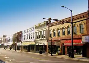 Downtown Elkin Historic District |
November 1, 2000 (#00001292) |
Roughly bounded by Market St., Hugh Chatham Bridge, Standard St., and Front St. 36°14′37″N 80°51′01″W |
Elkin | |
| 9 | Bernard Franklin House | 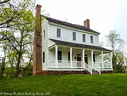 Bernard Franklin House |
April 24, 1973 (#73001369) |
Northwest of Dobson on SR 1331 36°27′24″N 80°49′13″W |
Dobson | |
| 10 | Ben and Barbara Graves House |  Ben and Barbara Graves House |
December 19, 2019 (#100004799) |
309 Fairview Ave. 36°31′06″N 80°36′36″W |
Mount Airy | |
| 11 | Gwyn Avenue-Bridge Street Historic District |  Gwyn Avenue-Bridge Street Historic District |
August 28, 2007 (#07000882) |
Roughly bounded by N. Bridge St., Mill View Rd., Market St. and Church St. 36°14′42″N 80°50′56″W |
Elkin | |
| 12 | Hauser Farm |  Hauser Farm |
March 1, 2002 (#02000113) |
308 Horne Creek Farm Rd. 36°15′59″N 80°29′09″W |
Pinnacle | |
| 13 | Haystack Farm | December 2, 1982 (#82001306) |
South of Oak Grove on SR 1480 36°27′31″N 80°44′56″W |
Oak Grove | ||
| 14 | Edgar Harvey Hennis House | 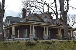 Edgar Harvey Hennis House |
February 20, 1986 (#86000318) |
1056 N. Main St. 36°30′44″N 80°36′29″W |
Mount Airy | |
| 15 | Hugh Chatham Memorial Hospital, (former) | .jpg.webp) Hugh Chatham Memorial Hospital, (former) |
May 2, 2002 (#02000437) |
230 Hawthorne Rd. 36°15′17″N 80°50′45″W |
Elkin | |
| 16 | J. J. Jones High School | April 27, 2021 (#100006464) |
213-215 Jones School Rd. 36°31′53″N 80°36′12″W |
Mount Airy | ||
| 17 | Lebanon Hill Historic District | December 22, 2020 (#100005978) |
Roughly bounded by Howard, Mitchell, South, and Woodruff Sts., and the Mount Airy Historic District 36°30′41″N 80°36′40″W |
Mount Airy | ||
| 18 | Marion House and Marion Brothers Store | 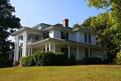 Marion House and Marion Brothers Store |
December 26, 2012 (#12001090) |
7034 Siloam Rd. 36°17′10″N 80°33′52″W |
Siloam | |
| 19 | William Alfred Moore House |  William Alfred Moore House |
March 5, 1986 (#86000406) |
202 Moore Ave. 36°30′06″N 80°36′21″W |
Mount Airy | |
| 20 | Mount Airy Historic District | 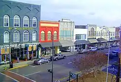 Mount Airy Historic District |
October 3, 1985 (#85002931) |
Main, Brown, Market, Franklin, W. Pine, Rockford, Worth, Cherry, and Gilmer Sts., and Moore and Hines Aves.; also Willow and W. Oak Sts.; also 409, 417-423 Franklin St.; 418 West Pine St., 3 unaddressed parcels at the east corner of South Main and Hamburg Sts., and 209, 215, 218, 219 Hines Ave.; also includes portions of Bank, Broad, West Church, Durham, West Elm, Hadley, East and West Haymore, North Main, Maple, Merritt, Price, Rockford, Spring, and Willow Sts., Maiden Ln., Patterson and Rawley Aves., 36°29′59″N 80°36′25″W |
Mount Airy | Second set of boundaries represents a boundary increase of August 28, 2012; third set represent a boundary decrease of April 9, 2021; fourth set represent a boundary increase of April 27, 2021. |
| 21 | North Carolina Granite Corporation Quarry Complex | 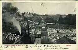 North Carolina Granite Corporation Quarry Complex |
August 6, 1980 (#80002900) |
East of Mount Airy on NC 103 36°30′29″N 80°35′10″W |
Mount Airy | |
| 22 | Pilot Hosiery Mill | August 24, 2021 (#100006855) |
224 East Main St. 36°23′01″N 80°27′51″W |
Pilot Mountain | ||
| 23 | Pilot Mountain Downtown Historic District | 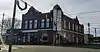 Pilot Mountain Downtown Historic District |
April 14, 2022 (#100007599) |
Portions of 100 and 200 blks. East Main, 100 blk. West Main, 100 blk. Depot, 100 blk. West Marian, and 100 blk. South Stephens Sts. 36°23′11″N 80°28′12″W |
Pilot Mountain | |
| 24 | Renfro Mill | 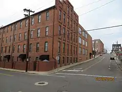 Renfro Mill |
October 12, 2000 (#00001208) |
Junction of Willow and Oak Sts. 36°30′05″N 80°36′36″W |
Mount Airy | |
| 25 | Ridge Westfield Elementary School | 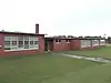 Ridge Westfield Elementary School |
December 19, 2019 (#100004794) |
4416 Westfield Rd. 36°30′40″N 80°30′22″W |
Mount Airy | |
| 26 | Rockford Historic District | 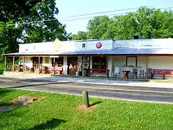 Rockford Historic District |
August 27, 1976 (#76001338) |
SR 2221 36°16′09″N 80°39′10″W |
Rockford | |
| 27 | Surry County Courthouse |  Surry County Courthouse |
May 10, 1979 (#79001751) |
N. Main St. between School and Kapp Sts. 36°23′45″N 80°43′25″W |
Dobson | |
| 28 | Taylor Park Historic District | April 27, 2021 (#100006466) |
Includes all or portions of Charles, Grace, Howard, North Main, and Marion Sts., Crescent Dr., North and South Park, and Wrenn Aves. 36°30′53″N 80°36′26″W |
Mount Airy | ||
| 29 | Trinity Episcopal Church | 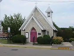 Trinity Episcopal Church |
January 9, 1986 (#86000031) |
472 N. Main St. 36°30′12″N 80°36′31″W |
Mount Airy |
See also
Wikimedia Commons has media related to National Register of Historic Places in Surry County, North Carolina.
References
- The latitude and longitude information provided in this table was derived originally from the National Register Information System, which has been found to be fairly accurate for about 99% of listings. Some locations in this table may have been corrected to current GPS standards.
- National Park Service, United States Department of the Interior, "National Register of Historic Places: Weekly List Actions", retrieved October 20, 2023.
- Numbers represent an alphabetical ordering by significant words. Various colorings, defined here, differentiate National Historic Landmarks and historic districts from other NRHP buildings, structures, sites or objects.
- The eight-digit number below each date is the number assigned to each location in the National Register Information System database, which can be viewed by clicking the number.

| Topics | |
|---|---|
| Lists by state |
|
| Lists by insular areas | |
| Lists by associated state | |
| Other areas | |
| Related | |
Municipalities and communities of Surry County, North Carolina, United States | ||
|---|---|---|
| City | Map of North Carolina highlighting Surry County | |
| Towns | ||
| Townships | ||
| CDPs | ||
| Unincorporated communities |
| |
| Footnotes | ‡This populated place also has portions in an adjacent county or counties | |
This article is issued from Wikipedia. The text is licensed under Creative Commons - Attribution - Sharealike. Additional terms may apply for the media files.