National Register of Historic Places listings in inner Harris County, Texas
This is a list of the National Register of Historic Places in inner Harris County, Texas, defined as within the I-610 loop within Harris County, Texas, but excluding those places in Downtown Houston and those in Houston Heights, which are listed separately. (Downtown Houston is defined as the area enclosed by Interstate 10, Interstate 45, and Interstate 69. Houston Heights is defined, approximately, by Highway I-10 on the South, I-610 on the North, 45 on the East and Durham on the West.)
| downtown Houston - Houston Heights - inner Harris County - outer Harris County |

This National Park Service list is complete through NPS recent listings posted October 20, 2023.[1]
The locations of National Register properties and districts (at least for all showing latitude and longitude coordinates below) may be seen in a map by clicking on "Map of all coordinates."[2]
Current listings
| [3] | Name on the Register | Image | Date listed[4] | Location | City or town | Description |
|---|---|---|---|---|---|---|
| 1 | 1879 Houston Waterworks | 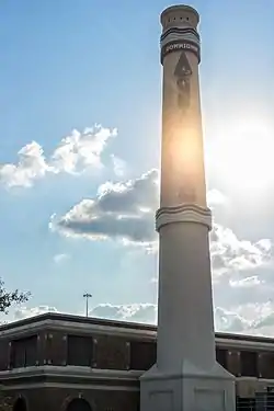 1879 Houston Waterworks |
May 6, 1976 (#76002037) |
27 Artesian Place 29°45′50″N 95°22′10″W |
Houston | |
| 2 | Almeda Road Bridge over Brays Bayou | 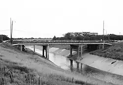 Almeda Road Bridge over Brays Bayou |
November 29, 2007 (#07001234) |
Almeda Rd. at Brays Bayou 29°42′47″N 95°22′55″W |
Houston | |
| 3 | The Astrodome | 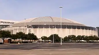 The Astrodome |
January 15, 2014 (#13001099) |
8400 Kirby Drive 29°41′06″N 95°24′28″W |
Houston | |
| 4 | James L. Autry House | 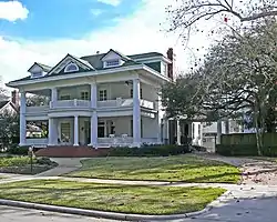 James L. Autry House |
June 14, 1979 (#79002953) |
5 Courtlandt Pl. 29°44′36″N 95°22′57″W |
Houston | |
| 5 | Aviary at the Houston Zoo |  Aviary at the Houston Zoo |
August 9, 2005 (#05000858) |
1513 N. McGregor 29°42′59″N 95°23′27″W |
Houston | |
| 6 | Bayou Bend |  Bayou Bend |
December 6, 1979 (#79002954) |
1 Westcott St. 29°45′27″N 95°25′14″W |
Houston | |
| 7 | Benjamin Apartments |  Benjamin Apartments |
September 26, 2002 (#02001063) |
1218 Webster St. 29°44′47″N 95°22′11″W |
Houston | |
| 8 | Bethel Baptist Church |  Bethel Baptist Church |
January 16, 1998 (#97001626) |
801 Andrews 29°45′04″N 95°22′33″W |
Houston | |
| 9 | Boulevard Oaks Historic District |  Boulevard Oaks Historic District |
February 22, 2002 (#02000117) |
Roughly bounded by North Blvd., South Blvd., Hazard and Mandell Sts. 29°43′37″N 95°24′13″W |
Houston | |
| 10 | Broadacres Historic District |  Broadacres Historic District |
April 16, 1980 (#80004128) |
1300-1506 North Blvd. and 1305-1515 South Blvd. 29°43′37″N 95°23′48″W |
Houston | |
| 11 | Cameron Iron Works |  Cameron Iron Works |
February 7, 2020 (#100004967) |
711 Milby St. 29°44′42″N 95°20′22″W |
Houston | |
| 12 | J. J. Carroll House | June 14, 1979 (#79002955) |
16 Courtlandt Pl. 29°44′38″N 95°23′04″W |
Houston | ||
| 13 | W. T. Carter Jr. House | June 14, 1979 (#79002956) |
18 Courtlandt Pl. 29°44′38″N 95°23′05″W |
Houston | ||
| 14 | Cheek-Neal Coffee Company Building | 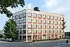 Cheek-Neal Coffee Company Building |
June 7, 2016 (#16000350) |
2017 Preston 29°45′22″N 95°21′07″W |
Houston | [5] |
| 15 | Clarke & Courts Building | Clarke & Courts Building |
April 14, 1994 (#94000354) |
1210 W. Clay Ave. 29°45′20″N 95°23′38″W |
Houston | |
| 16 | William L. Clayton Summer House | 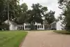 William L. Clayton Summer House |
February 2, 1984 (#84001756) |
3376 Inwood Dr. 29°46′44″N 95°25′46″W |
Houston | |
| 17 | A. S. Cleveland House | June 14, 1979 (#79002958) |
8 Courtlandt Pl. 29°44′38″N 95°23′00″W |
Houston | ||
| 18 | Courtlandt Place Historic District | 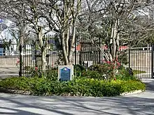 Courtlandt Place Historic District |
December 3, 1980 (#80004129) |
2-25 Courtlandt Pl. 29°44′37″N 95°23′03″W |
Houston | |
| 19 | James A. Dawson House | March 17, 1994 (#94000248) |
400 Emerson Ave. 29°44′29″N 95°23′01″W |
Houston | ||
| 20 | DePelchin Faith Home | 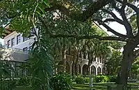 DePelchin Faith Home |
August 9, 1984 (#84001759) |
2700 Albany St. 29°44′57″N 95°22′58″W |
Houston | |
| 21 | Thomas J. Donoghue House | June 14, 1979 (#79002959) |
17 Courtlandt Pl. 29°44′36″N 95°23′05″W |
Houston | ||
| 22 | John M. Dorrance House | June 14, 1979 (#79002960) |
9 Courtlandt Pl. 29°44′36″N 95°22′59″W |
Houston | ||
| 23 | Charles W., Sr. and Mary Duncan House | July 24, 2017 (#100001374) |
3664 Inverness Dr. 29°45′09″N 95°26′14″W |
Houston | ||
| 24 | Eldorado Ballroom | February 1, 2022 (#100007402) |
2310 Elgin St. 29°44′05″N 95°21′55″W |
Houston | ||
| 25 | Ned A. and Linda S. Eppes House | 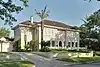 Ned A. and Linda S. Eppes House |
December 30, 1997 (#97001599) |
5322 Institute Ln. 29°43′29″N 95°23′50″W |
Houston | |
| 26 | Farnsworth & Chambers Building | 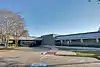 Farnsworth & Chambers Building |
October 29, 2009 (#09000866) |
2999 S. Wayside 29°42′22″N 95°19′06″W |
Houston | |
| 27 | Roy and Margaret Farrar House | October 4, 2006 (#06000923) |
511 Lovett Blvd. 29°44′35″N 95°23′16″W |
Houston | ||
| 28 | Fire Engine House No. 9 | October 17, 1985 (#85003238) |
1810-1812 Keene St. 29°46′31″N 95°21′05″W |
Houston | Demolished[6] | |
| 29 | First Evangelical Church | .jpg.webp) First Evangelical Church |
November 21, 2006 (#06001066) |
1311 Holman St. 29°44′25″N 95°22′32″W |
Houston | |
| 30 | Maria Boswell Flake Home for Old Women | 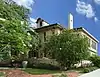 Maria Boswell Flake Home for Old Women |
May 11, 2018 (#100002435) |
1130 Berry St. 29°44′19″N 95°22′40″W |
Houston | |
| 31 | J. A. Folger and Company Plant | April 26, 2021 (#100006493) |
235 North Norwood St. 29°44′48″N 95°18′56″W |
Houston | ||
| 32 | Forum of Civics | 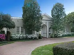 Forum of Civics |
October 13, 1988 (#88001053) |
2503 Westheimer Rd. 29°44′30″N 95°25′04″W |
Houston | |
| 33 | Freedmen's Town Historic District | 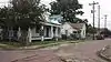 Freedmen's Town Historic District |
January 17, 1985 (#85000186) |
Roughly Bounded by Genesse, West Dallas, Arthur and W. Gray Sts. 29°45′19″N 95°22′49″W |
Houston | |
| 34 | Heights State Bank Building | 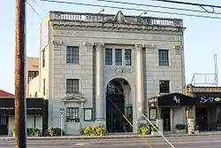 Heights State Bank Building |
June 22, 1983 (#83004439) |
3620 Washington St. 29°46′11″N 95°23′48″W |
Houston | |
| 35 | Hermann Park Municipal Golf Clubhouse | 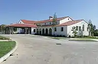 Hermann Park Municipal Golf Clubhouse |
February 7, 2020 (#100004968) |
6201 Hermann Park Dr. 29°42′51″N 95°23′20″W |
Houston | |
| 36 | Fred J. Heyne House | .jpg.webp) Fred J. Heyne House |
March 25, 1994 (#94000266) |
220 Westmoreland Ave. 29°44′25″N 95°23′04″W |
Houston | |
| 37 | Hill Street Bridge over Buffalo Bayou | 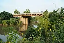 Hill Street Bridge over Buffalo Bayou |
October 31, 2007 (#07001131) |
S. Jensen Dr. at Buffalo Bayou 29°45′40″N 95°20′36″W |
Houston | |
| 38 | Hollyfield Laundry and Cleaners | February 28, 2017 (#100006770) |
1731 Westheimer Rd. 29°44′34″N 95°24′13″W |
Houston | ||
| 39 | Houston Fire Station No. 3 | 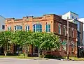 Houston Fire Station No. 3 |
February 28, 2017 (#100000696) |
1919 Houston Ave. 29°46′30″N 95°22′22″W |
Houston | |
| 40 | Houston Fire Station No. 7 |  Houston Fire Station No. 7 |
April 17, 1986 (#86000798) |
2403 Milam St. 29°44′51″N 95°22′29″W |
Houston | |
| 41 | Houston Negro Hospital | .jpg.webp) Houston Negro Hospital |
December 27, 1982 (#82004856) |
3204 Ennis St. 29°43′52″N 95°21′37″W |
Houston | |
| 42 | Houston Negro Hospital School of Nursing Building | 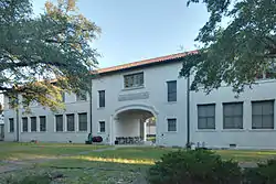 Houston Negro Hospital School of Nursing Building |
December 27, 1982 (#82004857) |
Holman Ave. and Ennis St. 29°43′34″N 95°21′26″W |
Houston | |
| 43 | Houston Post | April 2, 2018 (#100002269) |
2410 Polk St. 29°44′50″N 95°21′16″W |
Houston | ||
| 44 | Idylwood Historic District | July 6, 2011 (#11000425) |
Roughly bounded by Lawndale Ave., N. MacGregor Way, Sylvan Rd. & Wayside Dr. 29°43′15″N 95°18′36″W |
Houston | ||
| 45 | Isabella Court | .jpg.webp) Isabella Court |
June 24, 1994 (#94000628) |
3909-3917 S. Main St. 29°44′11″N 95°22′50″W |
Houston | |
| 46 | Jefferson Davis Hospital | .jpg.webp) Jefferson Davis Hospital |
August 10, 2005 (#05000859) |
1101 Elder 29°46′10″N 95°22′07″W |
Houston | |
| 47 | Morris and Mary Johnson House | June 4, 1997 (#97000541) |
3818 Spencer St. 29°46′30″N 95°23′58″W |
Houston | Demolished[7] | |
| 48 | Jones-Hunt House | June 14, 1979 (#79002962) |
24 Courtlandt Pl. 29°44′38″N 95°23′09″W |
Houston | ||
| 49 | Lewis Apartment Building | .jpg.webp) Lewis Apartment Building |
May 24, 1996 (#96000587) |
2815-2817 Smith St. 29°44′43″N 95°22′44″W |
Houston | |
| 50 | Link-Lee House | .jpg.webp) Link-Lee House |
September 11, 2000 (#00000751) |
3800 Montrose 29°44′16″N 95°23′29″W |
Houston | |
| 51 | Logue House |  Logue House |
April 30, 1998 (#98000428) |
1101 Milford 29°43′44″N 95°23′31″W |
Houston | |
| 52 | Leonard W. Macatee House | 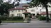 Leonard W. Macatee House |
May 6, 2005 (#05000387) |
1220 Southmore Blvd. 29°43′37″N 95°23′07″W |
Houston | |
| 53 | Marguerite Meachum & John S. Mellinger House | June 20, 2012 (#12000351) |
3452 Del Monte Drive 29°45′04″N 95°25′58″W |
Houston | ||
| 54 | Mechanical Laboratory and Power House |  Mechanical Laboratory and Power House |
January 14, 2021 (#100006045) |
6100 Main St. (Rice University) 29°42′56″N 95°23′52″W |
Houston | |
| 55 | Medical Towers | 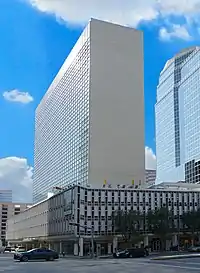 Medical Towers |
December 27, 2016 (#16000918) |
1709 Dryden Rd. 29°42′35″N 95°24′05″W |
Houston | |
| 56 | James V. Meek House | .jpg.webp) James V. Meek House |
March 17, 1994 (#94000247) |
3704 Garrott Ave. 29°44′22″N 95°23′08″W |
Houston | |
| 57 | Ezekial and Mary Jane Miller House | .jpg.webp) Ezekial and Mary Jane Miller House |
October 6, 1983 (#83003788) |
304 Hawthorne St. 29°44′36″N 95°23′02″W |
Houston | |
| 58 | Simon and Mamie Minchen House | 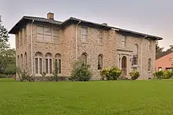 Simon and Mamie Minchen House |
December 7, 2000 (#00001496) |
1753 North Blvd. 29°43′45″N 95°24′15″W |
Houston | |
| 59 | Angelo and Lillian Minella House | 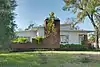 Angelo and Lillian Minella House |
September 13, 2006 (#06000818) |
6328 Brookside Dr. 29°43′52″N 95°18′59″W |
Houston | |
| 60 | Sterling Myer House | June 14, 1979 (#79002964) |
4 Courtlandt Pl. 29°44′37″N 95°22′55″W |
Houston | ||
| 61 | Myers-Spalti Manufacturing Plant | 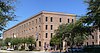 Myers-Spalti Manufacturing Plant |
September 12, 2003 (#03000936) |
2115 Runnels St. 29°45′45″N 95°20′49″W |
Houston | |
| 62 | William R. Nash House | .jpg.webp) William R. Nash House |
August 23, 1990 (#90001293) |
215 Westmoreland Ave. 29°44′27″N 95°23′04″W |
Houston | |
| 63 | Near North Side Historic District | November 29, 2010 (#10000960) |
Roughly bounded by Little White Oak Bayou on the N; Hogan on the S; I-45 on the W and the block between N Main and Keene 29°46′42″N 95°21′55″W |
Houston | ||
| 64 | C. L. Neuhaus House | June 14, 1979 (#79002965) |
6 Courtlandt Pl. 29°44′38″N 95°22′58″W |
Houston | ||
| 65 | Hugo V. Neuhaus Jr. House | March 30, 2005 (#05000246) |
2910 Lazy Ln. 29°45′23″N 95°25′01″W |
Houston | ||
| 66 | Old Sixth Ward Historic District | Old Sixth Ward Historic District |
January 23, 1978 (#78002946) |
Bounded by Washington, Union, Houston, Capitol and Glenwood Cemetery 29°45′57″N 95°22′38″W |
Houston | |
| 67 | The Orange Show | 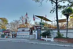 The Orange Show |
November 21, 2006 (#06001063) |
2401 Munger St. 29°43′10″N 95°19′28″W |
Houston | |
| 68 | Edward Albert Palmer Memorial Chapel and Autry House | 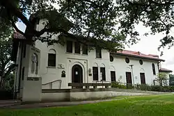 Edward Albert Palmer Memorial Chapel and Autry House |
October 31, 1984 (#84000388) |
6221 and 6265 Main St. 29°42′57″N 95°23′47″W |
Houston | |
| 69 | John W. Parker House | June 14, 1979 (#79002966) |
2 Courtlandt Pl. 29°44′38″N 95°22′55″W |
Houston | ||
| 70 | D. D. Peden House | July 16, 1991 (#91000889) |
2 Longfellow Ln. 29°43′21″N 95°23′35″W |
Houston | ||
| 71 | Rothko Chapel | 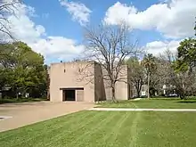 Rothko Chapel |
August 16, 2000 (#00000883) |
1409 Sul Ross Ave. 29°44′15″N 95°23′46″W |
Houston | |
| 72 | Sabine Street Bridge over Buffalo Bayou | .jpg.webp) Sabine Street Bridge over Buffalo Bayou |
September 28, 2007 (#07001023) |
Sabine St. at Buffalo Bayou 29°45′45″N 95°22′31″W |
Houston | |
| 73 | St. Elizabeth's Hospital | St. Elizabeth's Hospital |
March 6, 2019 (#100003489) |
4514 Lyons Ave. 29°46′33″N 95°19′28″W |
Houston | |
| 74 | St. Paul's Methodist Episcopal Church | September 12, 2019 (#100004373) |
5501 Main St. 29°43′33″N 95°23′19″W |
Houston | ||
| 75 | San Felipe Courts Historic District | .jpg.webp) San Felipe Courts Historic District |
February 16, 1988 (#88000042) |
1 Allen Pkwy. Village 29°45′34″N 95°22′42″W |
Houston | |
| 76 | San Jacinto Senior High School | 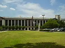 San Jacinto Senior High School |
December 5, 2012 (#12001000) |
Houston Community College Central 1300 Holman St. 29°44′15″N 95°22′36″W |
Houston | Consists of three contributing buildings[8] |
| 77 | Schlumberger Well Surveying Corporation Building | 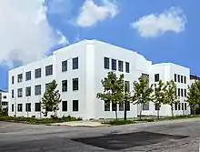 Schlumberger Well Surveying Corporation Building |
June 24, 2018 (#10002601) |
2720 Leeland Street 29°44′35″N 95°21′12″W |
Houston | |
| 78 | Sears, Roebuck and Company Warehouse and Service Center | Sears, Roebuck and Company Warehouse and Service Center |
June 25, 2020 (#100005314) |
5901 Griggs Rd. 29°41′56″N 95°19′31″W |
Houston | |
| 79 | Sessums-James House | November 19, 1998 (#98001344) |
3802 Spencer 29°46′30″N 95°23′57″W |
Houston | Demolished[9] | |
| 80 | Cleveland Harding Sewall House |  Cleveland Harding Sewall House |
April 14, 1975 (#75001991) |
3452 Inwood St. 29°45′07″N 95°25′48″W |
Houston | |
| 81 | Sheridan Apartments | 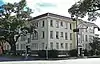 Sheridan Apartments |
August 2, 1984 (#84001825) |
802-804 McGowen St. 29°44′45″N 95°22′32″W |
Houston | |
| 82 | Star Engraving Company Building | .jpg.webp) Star Engraving Company Building |
January 6, 1995 (#94001521) |
3201 Allen Pkwy. 29°45′36″N 95°23′19″W |
Houston | |
| 83 | Sterling-Berry House | July 14, 1983 (#83004479) |
4515 Yoakum Blvd. 29°43′56″N 95°23′32″W |
Houston | ||
| 84 | Joseph R. and Mary M. Stevenson House | 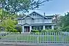 Joseph R. and Mary M. Stevenson House |
March 21, 1996 (#96000275) |
804 Harold St. 29°44′28″N 95°23′20″W |
Houston | |
| 85 | Judson L. Taylor House | June 14, 1979 (#79002968) |
20 Courtlandt Pl. 29°44′38″N 95°23′06″W |
Houston | Colonial Revival house designed by Birdsall Briscoe | |
| 86 | Telephone Road Bridge over Brays Bayou | 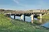 Telephone Road Bridge over Brays Bayou |
November 29, 2007 (#07001235) |
Telephone Rd. at Brays Bayou 29°42′37″N 95°18′48″W |
Houston | |
| 87 | Temple Beth Israel | 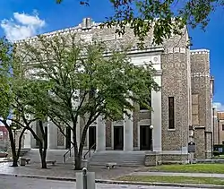 Temple Beth Israel |
March 1, 1984 (#84001826) |
3517 Austin St. 29°44′12″N 95°22′30″W |
Houston | |
| 88 | Lucie Wray and Anderson Todd House | August 31, 2018 (#100002842) |
9 Shadowlawn Cir. 29°43′28″N 95°23′42″W |
Houston | ||
| 89 | Trinity Church |  Trinity Church |
May 26, 1983 (#83004481) |
3404 S. Main St. 29°44′22″N 95°22′39″W |
Houston | |
| 90 | Union Transfer and Storage Building | .jpg.webp) Union Transfer and Storage Building |
January 16, 2001 (#00001665) |
1113 Vine St. 29°46′12″N 95°21′25″W |
Houston | |
| 91 | W-K-M Company, Inc. Historic District | June 25, 2018 (#100002602) |
Roughly bounded by Commerce, Sampson, Preston & Velasco Streets 29°45′03″N 95°20′27″W |
Houston | ||
| 92 | West Eleventh Place Historic District |  West Eleventh Place Historic District |
April 14, 1997 (#97000317) |
1-8 W. 11th Pl. 29°43′31″N 95°23′31″W |
Houston | |
| 93 | Westmoreland Historic District |  Westmoreland Historic District |
August 16, 1994 (#94000859) |
Bounded by Hawthorne, Burlington and Marshall Aves., and Garott St. 29°44′26″N 95°23′00″W |
Houston | |
| 94 | Andrew Jackson and Margaret Cullinan Wray House | Andrew Jackson and Margaret Cullinan Wray House |
August 19, 1993 (#93000844) |
3 Remington Ln. 29°43′25″N 95°23′35″W |
Houston |
Former listings
| [3] | Name on the Register | Image | Date listed | Date removed | Location | City or town | Description |
|---|---|---|---|---|---|---|---|
| 1 | Houston Turn-Verein | March 21, 1978 (#78002944) | July 24, 2017 | 5202 Almeda Rd. 29°43′23″N 95°22′44″W |
Houston | Demolished in 1993[10] | |
| 2 | Allen Paul House | September 27, 1980 (#80004127) | June 8, 1998 | 2201 Fannin St. 29°44′51″N 95°22′16″W |
Houston | Also known as the Witch's Hat House. Demolished 1997[11] |
See also
References
- National Park Service, United States Department of the Interior, "National Register of Historic Places: Weekly List Actions", retrieved October 20, 2023.
- The latitude and longitude information provided in this table was derived originally from the National Register Information System, which has been found to be fairly accurate for about 99% of listings. Some locations in this table may have been corrected to current GPS standards.
- Numbers represent an alphabetical ordering by significant words. Various colorings, defined here, differentiate National Historic Landmarks and historic districts from other NRHP buildings, structures, sites or objects.
- The eight-digit number below each date is the number assigned to each location in the National Register Information System database, which can be viewed by clicking the number.
- "Archived copy" (PDF). Archived from the original (PDF) on 2016-03-04. Retrieved 2018-10-24.
{{cite web}}: CS1 maint: archived copy as title (link) - https://www.houstontx.gov/planning/HistoricPres/landmarks/97L041_Fire-Station_No7_Houston-Fire-Museum_2403_Milam.pdf
- http://houston.novusagenda.com/agendapublic/AttachmentViewer.ashx?AttachmentID=29224&ItemID=7954
- http://houston.novusagenda.com/agendapublic/AttachmentViewer.ashx?AttachmentID=29224&ItemID=7954
- "Houston Deco | 1920s | Houston Turn-Verein Clubhouse".
- Houston Chronicle
External links
| Topics | |
|---|---|
| Lists by state |
|
| Lists by insular areas | |
| Lists by associated state | |
| Other areas | |
| Related | |