North-East District (Penang)
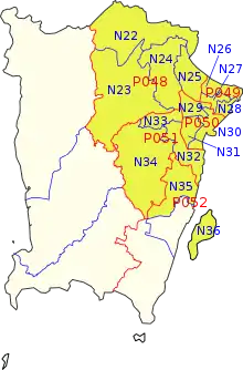
The North-East District (Malay: Daerah Timur Laut) is a district within the Malaysian state of Penang. The district covers the northeastern half of Penang Island, including the centre of George Town, Penang's capital city. It has an area of 122.79 km2 (47.41 sq mi) and a population of 510,996 as of 2010. The district borders the South-West District (Penang)|South-West District to the south-west.
North-East District | |
|---|---|
| Daerah Timur Laut | |
| Other transcription(s) | |
| • Malay | Daerah Timur Laut (Rumi) دايره تيمور لاوت (Jawi) |
| • Chinese | 东北县 (Simplified) 東北縣(Traditional) |
| • Tamil | வடகிழக்கு பினாங்கு தீவு மாவட்டம் Vaṭakiḻakku Piṉāṅku Tīvu Māvaṭṭam (Transliteration) |
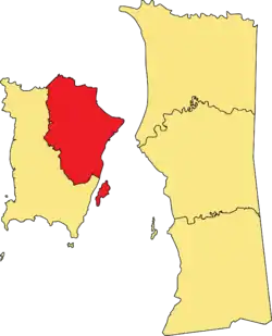 Location of the North-East District within the State of Penang. | |
| Country | |
| State | |
| Seat | George Town |
| Government | |
| • Local government | Penang Island City Council |
| Area | |
| • Total | 122.79 km2 (47.41 sq mi) |
| Elevation | 14 m (46 ft) |
| Population (2010)[1] | |
| • Total | 510,996 |
| • Estimate (2015)[2] | 535,200 |
| • Density | 4,161.5/km2 (10,778/sq mi) |
| Time zone | UTC+8 (MST) |
| • Summer (DST) | Not observed |
| Postal code | 100xx to 108xx
111xx to 118xx |
| Vehicle registration plates | P |
| Area code(s) | +604 |
| Website | dtl |
History
In 1786, the British East India Company had gained control of Penang Island, establishing the city of George Town at the island's northeastern tip. In the following decades, the entirety of the island was governed directly from George Town.
In 1888, the South-West District office was established in Balik Pulau at the southwest of the island, thus dividing the island into the North-East and South-West districts. Both districts on Penang Island first appeared in official maps dating back to the 1890s.[3]
Geography
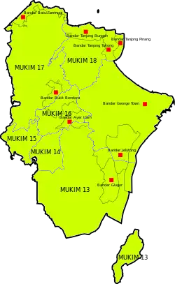
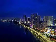
The District and Land Office of the North-East District is situated within the heart of George Town, which is also the capital city of the State of Penang. In addition, the district covers the following suburbs of George Town.
The Northeast Penang Island District also includes much of Penang Island's central hill ranges. Penang Hill, the tallest peak on Penang Island, is within the district and serves as a major tourist attraction.
The North-East District is further divided into seven mukims.[1]
- George Town
- Paya Terubong
- Bukit Paya Terubong
- Bukit Ayer Itam
- Ayer Itam
- Batu Ferringi
- Tanjong Tokong
Governance
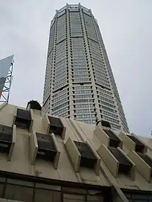
The District and Land Office is situated within Komtar, the tallest skyscraper in Penang.[4]
Local government
Although the districts in Malaysia were created for the purpose of land administration and revenue, in practice, it is the local government that ensures the provision of basic amenities and maintenance of urban infrastructure.
Notably, both districts on Penang Island are under the jurisdiction of the Penang Island City Council, which is also based in the centre of George Town. With a history dating back to 1800, it is the oldest local authority in Malaysia. The current Mayor of Penang Island is Yew Tung Seang, who was appointed into the position by the Penang state government in 2018.[5] The Mayor's term lasts for two years.[6]
Electoral constituencies
| Federal Constituency | Party | Member of Parliament | State Constituency | Party | State Assemblyman |
|---|---|---|---|---|---|
| Bukit Bendera (P048) | DAP | Syerleena Abdul Rashid | Tanjong Bunga (N22) | DAP | Zairil Khir Johari |
| Air Putih (N23) | DAP | Lim Guan Eng | |||
| Kebun Bunga (N24) | PKR | Ong Khan Lee | |||
| Pulau Tikus (N25) | DAP | Chris Lee Chun Kit | |||
| Tanjong (P049) | DAP | Chow Kon Yeow | Padang Kota (N26) | DAP | Chow Kon Yeow |
| Pengkalan Kota (N27) | DAP | Gooi Zi Sen | |||
| Komtar (N28) | DAP | Teh Lai Heng | |||
| Jelutong (P050) | DAP | RSN Rayer | Datok Keramat (N29) | DAP | Jagdeep Singh Deo |
| Sungai Pinang (N30) | DAP | Lim Siew Khim | |||
| Batu Lancang (N31) | DAP | Ong Ah Teong | |||
| Bukit Gelugor (P051) | DAP | Ramkarpal Singh | Seri Delima (N32) | DAP | Syerleena Abdul Rashid |
| Air Itam (N33) | DAP | Joseph Ng Soon Seong | |||
| Paya Terubong (N34) | DAP | Yeoh Soon Hin | |||
| Bayan Baru (P052) | PKR | Sim Tze Tzin | Batu Uban (N35) | PKR | Kumaresan Aramugam |
Demographics
| Year | Pop. | ±% |
|---|---|---|
| 1991 | 395,714 | — |
| 2000 | 416,369 | +5.2% |
| 2010 | 510,996 | +22.7% |
| 2020 | 556,575 | +8.9% |
| Source: [7] | ||
The following is based on the 2020 Malaysian Census conducted by Malaysia's Department of Statistics.[1]
| Ethnicity | Population | Percentage (%) |
|---|---|---|
| Chinese | 325,394 | 58.46 |
| Malay | 121,895 | 21.90 |
| Indian | 51,377 | 9.23 |
| Other ethnicities | 5,037 | 0.90 |
| Non-Malaysian citizens | 52,875 | 9.50 |
| Total | 556,575 | 100.00 |
Education
.jpg.webp)
The district is where some of the oldest schools in Malaysia were established. Penang Free School, founded in 1816, is the oldest English school in Southeast Asia, as well as the first of several missionary schools in the city. These English-medium schools, including St. Xavier's Institution, St. George's Girls School and Methodist Boys' School have produced some of Malaysia's most influential figures, including lawmakers, politicians, professionals and businessmen.
In addition, the first Chinese schools in Malaysia were established within the district. Since then, Chinese schools like Chung Ling High School, Heng Ee High School and Penang Chinese Girls' High School have maintained strong reputations based on academic excellence.
International schools have also been established within the city to cater to the growing expatriate population. These schools offer primary to secondary education up to A Levels and International Baccalaureate.
In terms of tertiary education, the district is home to one of the best Malaysian public universities - Universiti Sains Malaysia, as well as several private colleges and institutions such as Wawasan Open University, SEGi College and Han Chiang College.
The Penang State Library operates a branch and a children's library within the district.[8]
Health care
.jpg.webp)
In recent years, George Town has become the medical tourism centre of Malaysia, generating about 70% of the country's medical tourism revenue and attracting approximately half of medical tourist arrivals into the country.[9][10][11] The numerous public and private hospitals in the district, coupled with low cost of living and ease of travel have helped facilitate the medical tourism boom.
The Penang General Hospital is the main public hospital for George Town and the district. Built in 1882, it also serves as the reference hospital within northern Malaysia.[12]
Private hospitals, including Penang Adventist Hospital and Lam Wah Ee Hospital, also offer advanced facilities and speedier care by well-trained professionals. These hospitals cater not only to the local population but also patients from other states and neighbouring countries such as Indonesia and Singapore.[13]
Transportation

Land

The district is linked with the Malay Peninsula via the Penang Bridge, which runs between the George Town suburb of Gelugor and Perai on the mainland.
George Town has a relatively well-developed road network stretching back to the early days of British colonisation. Within the city centre are narrow streets and lanes, while modern arterial roads connect the city centre with the suburbs such as Tanjung Tokong, Air Itam and Jelutong.
The Tun Dr Lim Chong Eu Expressway runs along the eastern coastline of Penang Island between the city centre and the Penang International Airport, linking both locations with the Bayan Lepas Free Industrial Zone and the Penang Bridge.

Federal Route 6 is a winding trunk road that serves as the pan-island road, forming a circular loop round Penang Island. In the clockwise direction, this road connects the city centre with Bayan Lepas, Balik Pulau and Teluk Bahang.
Public transportation throughout Penang Island is composed of buses operated by Rapid Penang. In recent years, a free shuttle service within the city centre and double decker buses for tourists have also been introduced.[14][15]
The district also has the only operational railway on Penang Island - the Penang Hill Railway. It is the oldest funicular rail system in Malaysia, having commenced operations in 1923. It was last upgraded in 2011 with new coaches that take as little as five minutes to reach the peak of Penang Hill.
Sea
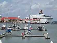
The Port of Penang consists of four terminals, one of which is located within the district. The Swettenham Pier serves not only cruise ships, but also on occasion, warships as well.[16][17][18] As of 2014, Swettenham Pier recorded 1.2 million tourist arrivals and attracted some of the world's biggest cruise liners, such as the RMS Queen Mary 2.[19]
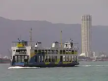
In addition, the Penang Ferry Service operates across the Penang Strait between George Town and Butterworth on the Malay Peninsula. At present, four ferries ply the route between George Town and Butterworth daily.
Tourist attractions
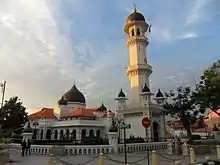
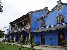
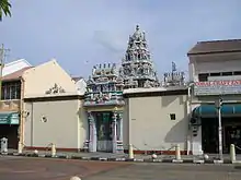
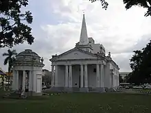
A great majority of Penang's tourist attractions lie within the centre of George Town. The city centre, a UNESCO World Heritage Site, is well-renowned for its architectural, cultural and culinary varieties; George Town is also said to be the food capital of Malaysia. In addition, the district has a number of natural attractions ranging from the central hills of Penang Island to the sandy beaches along the island's northern coastline.
Listed below are just some of the landmarks within the Northeast Penang Island District.
References
- "Population Distribution and Basic Demographic Characteristics, 2010" (PDF). Department of Statistics, Malaysia. Archived from the original (PDF) on 22 May 2014. Retrieved 19 April 2012.
- "2017 Q2 statistics" (PDF). Penang Institute. Archived from the original (PDF) on 2017-12-01. Retrieved 2017-11-30.
- "Map of Pinang Island and Province Wellesley,1897". www.nas.gov.sg. Retrieved 2018-01-24.
- "Pejabat Daerah Dan Tanah Daerah Timur Laut - Official Website For North-East Penang Land And District Office". dtl.penang.gov.my. Retrieved 2018-01-24.
- "Yew Tun Seang new mayor of Penang Island". 2018-01-17. Retrieved 2018-01-24.
- "Organisation Chart". Official Portal of Penang Island City Council (MBPP). 9 October 2015. Retrieved 15 October 2016.
- "Key Findings of Population and Housing Census of Malaysia 2020" (pdf) (in Malay and English). Department of Statistics, Malaysia. ISBN 978-967-2000-85-3.
- "Penang Library Corporation". Archived from the original on 2017-07-04.
- "Penang Monthly". penangmonthly.com.
- "Penang accounts for 50% of medical tourists". www.thesundaily.my.
- "Higher Education in Regional and City Development : State of Penang, Malaysia". OECD.
- "Penang to have first-ever school in hospital". NST Online. Retrieved 18 October 2016.
- "Getting back its mojo". The Economist. 13 August 2011. ISSN 0013-0613. Retrieved 18 October 2016.
- "Penang – The Pearl of the Orient". Equator Academy of Art. Archived from the original on 14 September 2008. Retrieved 27 July 2008.
- "Penang Hop-On Hop-Off".
- "Swettenham Pier Cruise Terminal". Penang Port.
- "Newspaper Article - S'pore gunboats call at Penang". eresources.nlb.gov.sg. Retrieved 18 October 2016.
- "US Navy ship calls at Penang - Community | The Star Online". www.thestar.com.my. Retrieved 18 October 2016.
- "Is Penang's tourism on the right track?". Penang Monthly. 1 October 2015. Retrieved 17 October 2016.