Beaufort District
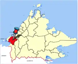
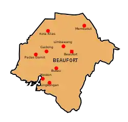
The Beaufort District (/ˈboʊfərt/; Malay: Daerah Beaufort) is an administrative district in the Malaysian state of Sabah, part of the Interior Division which includes the districts of Beaufort, Keningau, Kuala Penyu, Nabawan, Sipitang, Tambunan and Tenom. The population of Beaufort is composed mainly of Bisaya, Brunei Malays, Kadazan-Dusuns, Lun Bawang/Lun Dayeh, Muruts and Chinese (mainly Hakkas). Bisaya are the majority ethnic, and the population is scattered around the town. The capital of the district is in Beaufort Town.
Beaufort District
Daerah Beaufort | |
|---|---|
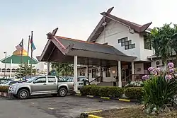
 Beaufort District Council office. | |
 | |
 | |
| Coordinates: 5°20′44.84″N 115°44′40.43″E | |
| Country | |
| State | |
| Division | Interior |
| Capital | Beaufort |
| Government | |
| • District Officer | Wong Foo Tin |
| Area | |
| • Total | 1,735 km2 (670 sq mi) |
| Population (2020[1]) | |
| • Total | 83,463 |
| • Density | 48/km2 (120/sq mi) |
| Postcode | 89XXX |
| Vehicle registration plates | SB |
| Website | www ww2 |
Etymology
The district was named after the former British North Borneo Governor Leicester Paul Beaufort.[2]
History
The area of Beaufort was discovered by the British in 1898 during the administration of the North Borneo Chartered Company.[3]
Demographics
| Year | Pop. | ±% |
|---|---|---|
| 1991 | 48,742 | — |
| 2000 | 62,200 | +27.6% |
| 2010 | 64,350 | +3.5% |
| 2020 | 75,716 | +17.7% |
| Source: [4] | ||
According to the 2020 census, the population by constituency was 52,107 inhabitants.[5] The main indigenous people of Beaufort are Bisaya, Brunei Malay, Kedayan and minority of Murut and Lun Bawang/Lundayeh.
| Ethnicity | 2020 | |
|---|---|---|
| Pop. | % | |
| Malays (incl. Bruneian Malays) | 11754 | 22.56% |
| Kadazan-Dusun | 14004 | 26.88% |
| Bajau | 4875 | 9.36% |
| Murut | 1123 | 2.16% |
| Other Bumiputeras | 14053 | 26.97% |
| Chinese | 2176 | 4.18% |
| Indians | 83 | 0.16% |
| Others | 434 | 0.83% |
| Malaysian total | 48502 | 93.08% |
| Non-Malaysian | 3605 | 6.92% |
| Total | 52107 | 100.00% |
The population by state legislative assembly are as follows:
| Beaufort (federal constituency) | 52,107 inhabitants |
|---|---|
| N.32 Klias | 28,397 |
| N.33 Kuala Penyu | 23,710 |
Gallery
 Beaufort Mosque.
 Lung Hwa Temple.
 Beaufort Basel Church.
See also
References
- "Sabah". www.mycensus.gov.my.
- "Latar belakang Daerah Beaufort" (in Malay). Beaufort District Council. Archived from the original on 12 September 2017. Retrieved 8 November 2017.
- "Profail Daerah Beaufort" (in Malay). Beaufort District Office. Archived from the original on 8 November 2017. Retrieved 8 November 2017.
- "Key Findings of Population and Housing Census of Malaysia 2020 Local Authority Area" (pdf) (in Malay and English). Department of Statistics, Malaysia. ISBN 978-967-253-697-0. Archived (PDF) from the original on 24 July 2023. Retrieved 24 July 2023.
- "Key Findings of Population and Housing Census of Malaysia 2020" (pdf) (in Malay and English). Department of Statistics, Malaysia. ISBN 978-967-2000-85-3.
Further reading
- Treacher, W. H (1891). "British Borneo: sketches of Brunai, Sarawak, Labuan, and North Borneo". University of California Libraries. Singapore, Govt. print. dept. p. 190.
- Rutter, Owen (1922). "British North Borneo - An Account of its History, Resources and Native Tribes". Cornell University Libraries. Constable & Company Ltd, London. p. 157.
- Tregonning, K. G. (1965). A History Of Modern Sabah (North Borneo 1881–1963). University of Malaya Press.
External links
![]() Media related to Beaufort District at Wikimedia Commons
Media related to Beaufort District at Wikimedia Commons
- (in Malay) Beaufort District Council
- (in Malay) Beaufort District Office