Odoornerveen
Odoornerveen is a village in the Dutch province of Drenthe. It is a part of the municipality of Borger-Odoorn, and lies about 12 km northwest of Emmen.
Odoornerveen | |
|---|---|
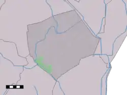 Odoornerveen in the municipality of Borger-Odoorn. | |
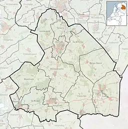 Odoornerveen Location in the province of Drenthe in the Netherlands  Odoornerveen Odoornerveen (Netherlands) | |
| Coordinates: 52.8374°N 6.7944°E | |
| Country | Netherlands |
| Province | Drenthe |
| Municipality | Borger-Odoorn |
| Area | |
| • Total | 17.58 km2 (6.79 sq mi) |
| Elevation | 18 m (59 ft) |
| Population (2021)[1] | |
| • Total | 415 |
| • Density | 24/km2 (61/sq mi) |
| Time zone | UTC+1 (CET) |
| • Summer (DST) | UTC+2 (CEST) |
| Postal code | 7874[1] |
| Dialing code | 0591 |
The village was first mentioned between 1851 and 1855 as "Odoorner veen", and means "peat colony of Odoorn". In 1854, the Oranjekanaal was dug to excavate the peat in the area and the village developed along the canal.[3] About 1,600 hectares (4,000 acres) of peat was excavated between 1856 and 1880, and the area was gradually cultivated for agriculture. Odoornerveen never had a church. The former pub was converted into a village house in 1984.[4]
References
- "Kerncijfers wijken en buurten 2021". Central Bureau of Statistics. Retrieved 11 April 2022.
- "Postcodetool for 7874TB". Actueel Hoogtebestand Nederland (in Dutch). Het Waterschapshuis. Retrieved 11 April 2022.
- "Odoornerveen - (geografische naam)". Etymologiebank (in Dutch). Retrieved 11 April 2022.
- "Odoornerveen". Plaatsengids (in Dutch). Retrieved 11 April 2022.
This article is issued from Wikipedia. The text is licensed under Creative Commons - Attribution - Sharealike. Additional terms may apply for the media files.