Ohio Township, Warrick County, Indiana
Ohio Township is one of ten townships in Warrick County, Indiana, United States. As of the 2010 census, its population was 37,749 and it contained 14,922 housing units.[1] It contains 63% of Warrick County's population. It has the third largest township population in Southwestern Indiana, behind two townships in Vanderburgh County and is one of the fastest-growing townships in Indiana. Ohio Township population grew 21.8% from the 2000 census to the 2010 census. Unlike most townships in Indiana, Ohio Township has two incorporated towns within its jurisdiction, Newburgh and Chandler.
Ohio Township Warrick County | |
|---|---|
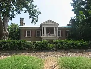
 The Roberts-Morton House, a historic place in Ohio Township | |
 Location in Warrick County | |
| Coordinates: 37°59′36″N 87°23′31″W | |
| Country | United States |
| State | Indiana |
| County | Warrick |
| Government | |
| • Type | Indiana township |
| Area | |
| • Total | 44.37 sq mi (114.9 km2) |
| • Land | 44.14 sq mi (114.3 km2) |
| • Water | 0.23 sq mi (0.6 km2) 0.52% |
| Elevation | 430 ft (131 m) |
| Population (2010) | |
| • Total | 37,749 |
| • Density | 855.3/sq mi (330.2/km2) |
| ZIP codes | 47601, 47610, 47630 |
| GNIS feature ID | 453685 |
History
Ohio Township was organized in 1826.[2] The township derives its name from the Ohio River, which forms its southern border.[3]
The Angel Mounds, Ellerbusch site, and Roberts-Morton House are listed on the National Register of Historic Places.[4]
Geography
According to the 2010 census, the township has a total area of 44.37 square miles (114.9 km2), of which 44.14 square miles (114.3 km2) (or 99.48%) is land and 0.23 square miles (0.60 km2) (or 0.52%) is water.[1]
Unincorporated towns
- Camp Brosend at 37.964488°N 87.395842°W
- Hillcrest Terrace at 37.948933°N 87.396397°W
- Paradise at 37.9956°N 87.379453°W
- Rustic Hills at 37.9556°N 87.367508°W
- Stevenson at 38.01671°N 87.433345°W
(This list is based on USGS data and may include former settlements.)
Adjacent townships
- Campbell Township (north)
- Boon Township (east)
- Anderson Township (southeast)
- Knight Township, Vanderburgh County (west)
Cemeteries
The township contains these four cemeteries: Casey, Greenwood, Hedge and Rose Hill.
Lakes
- Allens Lake
- Chase Lake
- Pfafflin Lake
School districts
Political districts
- Indiana's 8th congressional district
- State House District 75
- State House District 77
- State House District 78
- State Senate District 50
References
- United States Census Bureau 2007 TIGER/Line Shapefiles
- United States Board on Geographic Names (GNIS)
- IndianaMap
- "Population, Housing Units, Area, and Density: 2010 - County -- County Subdivision and Place -- 2010 Census Summary File 1". United States Census. Archived from the original on February 12, 2020. Retrieved May 10, 2013.
- History of Warrick, Spencer, and Perry Counties, Indiana: From the Earliest Time to the Present. Goodspeed. 1885. p. 43.
- Fortune, William (1881). Warrick and Its Prominent People: A History of Warrick County, Indiana from the Time of Its Organization and Settlement. Courier Company. p. 20.
- "National Register Information System". National Register of Historic Places. National Park Service. July 9, 2010.