Patate Canton
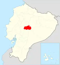
Patate Canton is a canton of Ecuador, located in the Tungurahua Province. Its capital is the town of Patate. Its population at the 2010 census was 13,497.[1]
Patate Canton | |
|---|---|
 Tungurahua Province in Ecuador | |
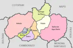 Cantons of Tungurahua Province | |
| Coordinates: 01°19′S 78°31′W | |
| Country | |
| Province | Tungurahua Province |
| Capital | Patate |
| Government | |
| • Mayor | Medardo Chiliquinga |
| Area | |
| • Total | 315 km2 (122 sq mi) |
| Population (2010) | |
| • Total | 13,497 |
| • Density | 42.85/km2 (111.0/sq mi) |
| Time zone | UTC-5 (ECT) |
| Area code | 593 |
| Website | Patate Autonomous Decentralized Government |
The still active Tungurahua volcano is situated within the canton.
Patate (town and canton) was declared a Pueblo Mágico (magical town) by Ecuador's Ministry of Tourism (MINTUR) in 2019. It was the first community in the country to be awarded this distinction.[2]
References
- "Estadísticas de la Semana". Archived from the original on 2014-02-26. Retrieved 2014-02-26. at statoids.com
- "Patate es oficialmente un 'Pueblo Mágico' del país". El Comercio. Retrieved 2021-04-02.
External links
This article is issued from Wikipedia. The text is licensed under Creative Commons - Attribution - Sharealike. Additional terms may apply for the media files.