Clark Township, Michigan
Clark Township is a civil township of Mackinac County in the U.S. state of Michigan. As of the 2020 census, the population was 1,917,[2] down from 2,256 in 2010.[5]
Clark Township, Michigan | |
|---|---|
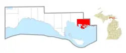 Location within Mackinac County | |
 Clark Township Location within the state of Michigan  Clark Township Location within the United States | |
| Coordinates: 45°59′57″N 84°20′41″W | |
| Country | United States |
| State | Michigan |
| County | Mackinac |
| Established | 1905 |
| Government | |
| • Supervisor | Mark Clymer |
| • Clerk | Susan Rutledge |
| Area | |
| • Total | 101.60 sq mi (263.14 km2) |
| • Land | 78.97 sq mi (204.53 km2) |
| • Water | 22.63 sq mi (58.61 km2) |
| Elevation | 673 ft (205 m) |
| Population | |
| • Total | 1,917 |
| • Density | 26.0/sq mi (10.0/km2) |
| Time zone | UTC-5 (Eastern (EST)) |
| • Summer (DST) | UTC-4 (EDT) |
| ZIP Codes | 49719 (Cedarville) 49745 (Hessel) |
| Area code | 906 |
| FIPS code | 26-097-16060[3] |
| GNIS feature ID | 1626088[4] |
| Website | www |
History
Clark Township was established in February 1905 by the consolidation of Sherwood Township and Cedar Township.[6] Cedar Township was established in March 1887.[7]
Geography
Clark Township is the easternmost township in Mackinac County. It is bordered to the west and northwest by Marquette Township, to the northeast by Chippewa County, and to the south by Lake Huron.
According to the U.S. Census Bureau, the township has a total area of 101.60 square miles (263.14 km2), of which 78.97 square miles (204.53 km2) are land and 22.63 square miles (58.61 km2) (22.27%) are water.[5] The southern part of the township is home to numerous bays and inlets of Lake Huron, as well the Les Cheneaux Islands.
Communities
- Cedarville is an unincorporated community at the junction of M-129 and M-134 at 45°59′53″N 84°21′47″W[8] north of the Les Cheneaux Islands, about 2 miles (3 km) east of Hessel, and about 35 miles (56 km) due south of Sault Ste. Marie. It began as a lumber settlement on the Lake Huron shore in 1884. A post office was established in July 1888.[9] The ZIP code of 49719 serves most of Clark Township. The Les Cheneaux Historical Association [10] runs the Historical Museum and the Maritime Museum, both in Cedarville. Les Cheneaux Culinary School is also there.[11]
- Coryell Islands in this township had a post office from 1908 until 1958.[12]
- Hessel is an unincorporated community on M-134 north of Marquette Island, the largest of the Les Cheneaux Islands at 46°00′15″N 84°25′33″W.[13] It was founded in 1885 by two Swedes and a Norwegian, John and Carl Hessel and John A. Johnson, and a post office was established in September 1888.[9] The ZIP code of 49745 serves Hessel and the western part of Clark Township.[14] Hessel is the home of the Antique Wooden Boat Show and Festival of the Arts,[15] which is held annually at the public docks on the second weekend of August.
- Patrick Landing is a named place in the township approximately one mile southwest of Cedarville on the Les Cheneaux Channel at 45°59′05″N 84°22′38″W.[16]
- Port Dolomite is a commercial port in the eastern end of the township at 45°59′05″N 84°16′30″W.[17] In 2004, it was the 93rd largest port in the United States ranked by tonnage.
Education
- The K-12 educational needs of Clark Township residents are served by Les Cheneaux Community Schools.
- Cedarville is home to Great Lakes Boat Building School, a post-secondary school focused on vocational training in the boat building and maritime trades.
Interests
- Cedar Cove is an assisted living establishment which houses a great place of information about the community and the area.
- The community dock is a place where many gather in the evening in good weather to see the sunset.
References
Notes
- "2022 U.S. Gazetteer Files: Michigan". United States Census Bureau. Retrieved August 11, 2023.
- "P1. Race – Clark township, Michigan: 2020 DEC Redistricting Data (PL 94-171)". U.S. Census Bureau. Retrieved August 11, 2023.
- "U.S. Census website". United States Census Bureau. Retrieved January 31, 2008.
- U.S. Geological Survey Geographic Names Information System: Clark Township, Michigan
- "Michigan: 2010 Population and Housing Unit Counts 2010 Census of Population and Housing" (PDF). 2010 United States Census. United States Census Bureau. September 2012. p. 31 Michigan. Archived (PDF) from the original on October 19, 2012. Retrieved September 17, 2021.
- "Bills Passed - Senate". Unionville Crescent. February 24, 1905.
- "Michigan Legislature". The True Northerner. March 23, 1887.
- U.S. Geological Survey Geographic Names Information System: Cedarville, Michigan
- Romig 1986.
- "Welcome". Archived from the original on October 18, 2019. Retrieved October 18, 2019.
- "The Les Cheneaux Culinary School". The Les Cheneaux Culinary School.
- Romig 1986, p. 135.
- U.S. Geological Survey Geographic Names Information System: Hessel, Michigan
- 49745 5-Digit ZCTA, 497 3-Digit ZCTA - Reference Map - American FactFinder, U.S. Census Bureau, 2000 Census
- "Boat Show/Festival of Arts". Archived from the original on October 18, 2019. Retrieved October 18, 2019.
- U.S. Geological Survey Geographic Names Information System: Patrick Landing, Michigan
- U.S. Geological Survey Geographic Names Information System: Port Dolomite
Sources
- Romig, Walter (October 1, 1986) [1973]. Michigan Place Names: The History of the Founding and the Naming of More Than Five Thousand Past and Present Michigan Communities. ISBN 0-8143-1838-X.
{{cite book}}:|work=ignored (help)
External links
Municipalities and communities of Mackinac County, Michigan, United States | ||
|---|---|---|
| Cities | 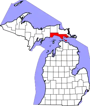 Map of Michigan highlighting Mackinac County.svg | |
| Civil townships | ||
| CDP | ||
| Other communities |
| |
| Indian reservations | ||
| Footnotes | ‡This populated place also has portions in an adjacent county or counties | |