Hudson Township, Mackinac County, Michigan
Hudson Township is a civil township of Mackinac County in the U.S. state of Michigan. As of the 2020 census, its population was 193.[2]
Hudson Township, Michigan | |
|---|---|
%252C_MI.jpg.webp) Community of Garnet along Hiawatha Trail | |
%252C_MI_location.png.webp) Location within Mackinac County | |
 Hudson Township Location within the state of Michigan  Hudson Township Location within the United States | |
| Coordinates: 46°08′32″N 85°17′34″W | |
| Country | United States |
| State | Michigan |
| County | Mackinac |
| Government | |
| • Supervisor | John Kostiuk |
| • Clerk | Barbara Kerridge |
| Area | |
| • Total | 69.42 sq mi (179.8 km2) |
| • Land | 68.77 sq mi (178.1 km2) |
| • Water | 0.65 sq mi (1.7 km2) |
| Elevation | 840 ft (256 m) |
| Population | |
| • Total | 193 |
| • Density | 2.63/sq mi (1.02/km2) |
| Time zone | UTC-5 (Eastern (EST)) |
| • Summer (DST) | UTC-4 (EDT) |
| ZIP Code | 49762 (Naubinway) |
| Area code | 906 |
| FIPS code | 26-097-39760[3] |
| GNIS feature ID | 1626500[4] |
Geography
The township is in western Mackinac County on the northern shore of Lake Michigan. It is bordered to the east by Hendricks Township and to the west by Garfield Township, both in Mackinac County; to the north by Pentland Township in Luce County; and at its northeast corner by Hulbert Township in Chippewa County.
According to the United States Census Bureau, Hudson Township has a total area of 69.42 square miles (179.80 km2), of which 68.77 square miles (178.11 km2) are land and 0.65 square miles (1.68 km2) (1.07%) are water.[1]
Highways
Attractions
- Garlyn Zoo is located within Hudson Township along U.S. Route 2.
- Garnet Lake State Forest Campground[5]
- Hog Island Point State Forest Campground[6]
Communities
- Garnet is an unincorporated community in the township at 46°09′30″N 85°18′24″W.[7] This was a stop on the Minneapolis, St. Paul and Sault Ste. Marie Railway named Welch in 1891. A settlement had developed around a sawmill and general store.[8] A post office opened with the name Welch on November 4, 1898. The name was changed to Garnet on December 31, 1904, and was discontinued on February 4, 1972. It was a rural branch/CPO until January 13, 1978.[9]
- Rexton is an unincorporated community in the township at 46°09′31″N 85°14′24″W.[10] It was the headquarters for the D. N. McLeod Lumber Company. Canadian bankers financed building the railroad through here, and the settlement is said to have been named in honor of the king of England.[8] A post office opened April 16, 1901 and was discontinued September 1, 1961. It became a station/branch until June 30, 1968.[11]
References
- "2022 U.S. Gazetteer Files: Michigan". United States Census Bureau. Retrieved August 14, 2023.
- "P1. Race – Hudson township, Michigan: 2020 DEC Redistricting Data (PL 94-171)". U.S. Census Bureau. Retrieved August 14, 2023.
- "U.S. Census website". United States Census Bureau. Retrieved January 31, 2008.
- U.S. Geological Survey Geographic Names Information System: Hudson Township, Mackinac County, Michigan
- Michigan Department of Natural Resources (2021). "Garnet Lake State Forest Campground". Retrieved July 4, 2021.
- Michigan Department of Natural Resources (2021). "Hog Island Point State Forest Campground". Retrieved July 4, 2021.
- U.S. Geological Survey Geographic Names Information System: Garnet, Michigan
- Romig, Walter (1986) [1973]. Michigan Place Names. Detroit, Michigan: Wayne State University Press. ISBN 0-8143-1838-X.
- U.S. Geological Survey Geographic Names Information System: Garnet Post Office (historical)
- U.S. Geological Survey Geographic Names Information System: Rexton, Michigan
- U.S. Geological Survey Geographic Names Information System: Rexton Post Office (historical)
Municipalities and communities of Mackinac County, Michigan, United States | ||
|---|---|---|
| Cities | 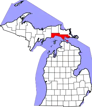 Map of Michigan highlighting Mackinac County.svg | |
| Civil townships | ||
| CDP | ||
| Other communities |
| |
| Indian reservations | ||
| Footnotes | ‡This populated place also has portions in an adjacent county or counties | |
This article is issued from Wikipedia. The text is licensed under Creative Commons - Attribution - Sharealike. Additional terms may apply for the media files.