Peizerwold
Peizerwold is a hamlet in the Netherlands and it part of the Noordenveld municipality in Drenthe.
Peizerwold | |
|---|---|
 Toll-house in Peizerwold The sign reads: horse and wagon: 4 ct; bicycles: 1 ct; cars: 10 ct | |
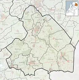 Peizerwold Location in province of Drenthe in the Netherlands  Peizerwold Peizerwold (Netherlands) | |
| Coordinates: 53°9′42″N 6°29′48″E | |
| Country | Netherlands |
| Province | Drenthe |
| Municipality | Noordenveld |
| Elevation | 2 m (7 ft) |
| Time zone | UTC+1 (CET) |
| • Summer (DST) | UTC+2 (CEST) |
| Postal code | 9321 |
| Dialing code | 050 |
Overview
Peizerwold is not a statistical entity,[2] and the postal authorities have placed it under Peize.[3] It was first mentioned in 1792 as Peyswold meaning "the woods near Peize".[4] The hamlet started during the peat exploitation in the forest near Peize. In 1840, it home to 78 people. Nowadays, it has about 20 houses.[5]
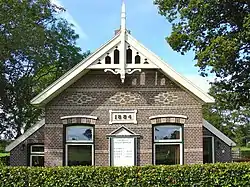
The tollhouse dates from 1884, and was built on the road to Groningen.[6] It was later in use a farm, but has been restored as a residential house. It was declared a monument in 1994.[7]
Gallery
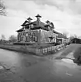 Farm Hoeve Woudrust
.jpg.webp) Street view
Street view
References
- "Postcodetool for 9321AA". Actueel Hoogtebestand Nederland (in Dutch). Het Waterschapshuis. Retrieved 10 March 2022.
- "Kerncijfers wijken en buurten 2021". Central Bureau of Statistics. Retrieved 10 March 2022.
Not listed
- "Postcode 9321 in Peize". Postcode bij adres (in Dutch). Retrieved 10 March 2022.
- "Peizerwold". Etymologiebank (in Dutch). Retrieved 10 March 2022.
- "Peizerwold". Plaatsengids (in Dutch). Retrieved 10 March 2022.
- "Peizerwold". Geheugen van Drenthe (in Dutch). Retrieved 10 March 2022.
- "Monumentnummer: 478022 Groningerweg 31 9321 TA te Peize". Dutch monuments register (in Dutch). Retrieved 10 March 2022.
This article is issued from Wikipedia. The text is licensed under Creative Commons - Attribution - Sharealike. Additional terms may apply for the media files.