Picabo, Idaho
Picabo /ˈpiːkəbuː/ is an unincorporated community in Blaine County, Idaho, United States.[1]
Picabo, Idaho | |
|---|---|
Community | |
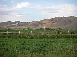
 Hills, mountains, and irrigated fields of Picabo | |
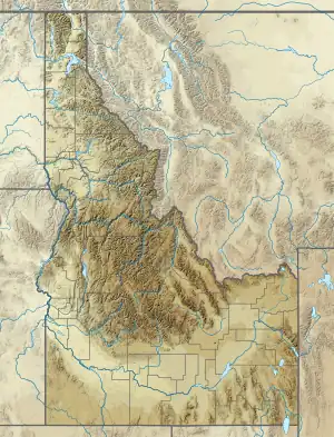
 Picabo, Idaho Location in Idaho  Picabo, Idaho Location in the United States | |
| Coordinates: 43°18′21″N 114°04′04″W | |
| Country | United States |
| State | |
| County | Blaine County |
| Physiographic region | Snake River Plain |
| Area | |
| • Total | 40.0 sq mi (103.5 km2) |
| Elevation | 4,839 ft (1,475 m) |
| Population (2000) | |
| • Total | 128 |
| • Density | 3.2/sq mi (1.2/km2) |
| Time zone | UTC-7 (Mountain Standard Time (MST)) |
| • Summer (DST) | UTC-6 (Mountain Daylight Time (MDT)) |
| Postal code | 83348 |
| Area codes | 208, 986 |
Description

Picabo is located along U.S. Route 20, about 6 miles (9.7 km) west of Carey, 19 miles (31 km) southeast of Hailey, and 31 miles (50 km) northeast of Shoshone. It has a gas station, country store, post office, and a small airport.[2] The community is surrounded by large ranches and irrigated fields. The 2000 United States census for this ZIP Code shows a population of 128 in 56 housing units in 104 km2 (40 square miles).
Picabo is located about 56 miles (90 km) north of the Snake River along the northern edge of the Snake River Plain, a topographic depression that cuts across the Basin and Range Mountain structures of southern Idaho. The nearest flowing stream is Silver Creek, a scenic spring-fed tributary of the Little Wood River, a key source of irrigation water for eastern Blaine County. The pristine Silver Creek is renowned among fly fishermen and was a favorite of Ernest Hemingway, who enjoyed hunting and fishing along the stream with local rancher, Bud Purdy.[3]
Name
The name "Picabo" supposedly derives from a Native American term translated as "silver water".[4] The name "Picabo" was made familiar by Picabo Street, an Olympic skier who grew up in nearby Triumph.[5]
Climate
According to the Köppen Climate Classification system, Picabo has a warm-summer mediterranean continental climate, abbreviated "Dsb" on climate maps. The hottest temperature recorded in Picabo was 102 °F (38.9 °C) on July 17, 1998 and July 11, 2002, while the coldest temperature recorded was −37 °F (−38.3 °C) on December 23, 1990.[6]
| Climate data for Picabo, Idaho, 1991–2020 normals, extremes 1958–present | |||||||||||||
|---|---|---|---|---|---|---|---|---|---|---|---|---|---|
| Month | Jan | Feb | Mar | Apr | May | Jun | Jul | Aug | Sep | Oct | Nov | Dec | Year |
| Record high °F (°C) | 53 (12) |
63 (17) |
72 (22) |
84 (29) |
92 (33) |
100 (38) |
102 (39) |
100 (38) |
99 (37) |
87 (31) |
70 (21) |
57 (14) |
102 (39) |
| Mean maximum °F (°C) | 43.6 (6.4) |
47.6 (8.7) |
60.9 (16.1) |
72.4 (22.4) |
82.2 (27.9) |
90.6 (32.6) |
96.7 (35.9) |
94.3 (34.6) |
89.0 (31.7) |
77.2 (25.1) |
60.4 (15.8) |
46.2 (7.9) |
97.5 (36.4) |
| Average high °F (°C) | 31.8 (−0.1) |
36.4 (2.4) |
46.5 (8.1) |
57.1 (13.9) |
67.1 (19.5) |
76.1 (24.5) |
86.8 (30.4) |
85.5 (29.7) |
75.6 (24.2) |
60.6 (15.9) |
44.5 (6.9) |
32.3 (0.2) |
58.4 (14.6) |
| Daily mean °F (°C) | 19.4 (−7.0) |
23.3 (−4.8) |
32.9 (0.5) |
41.2 (5.1) |
50.6 (10.3) |
57.6 (14.2) |
66.5 (19.2) |
65.2 (18.4) |
56.5 (13.6) |
44.0 (6.7) |
31.3 (−0.4) |
20.8 (−6.2) |
42.4 (5.8) |
| Average low °F (°C) | 7.1 (−13.8) |
10.1 (−12.2) |
19.3 (−7.1) |
25.3 (−3.7) |
34.1 (1.2) |
39.0 (3.9) |
46.2 (7.9) |
45.0 (7.2) |
37.4 (3.0) |
27.3 (−2.6) |
18.1 (−7.7) |
9.3 (−12.6) |
26.5 (−3.0) |
| Mean minimum °F (°C) | −9.0 (−22.8) |
−4.2 (−20.1) |
7.4 (−13.7) |
17.3 (−8.2) |
24.3 (−4.3) |
30.0 (−1.1) |
38.7 (3.7) |
36.7 (2.6) |
27.4 (−2.6) |
15.6 (−9.1) |
2.8 (−16.2) |
−7.7 (−22.1) |
−14.3 (−25.7) |
| Record low °F (°C) | −33 (−36) |
−30 (−34) |
−15 (−26) |
8 (−13) |
14 (−10) |
24 (−4) |
29 (−2) |
24 (−4) |
16 (−9) |
−3 (−19) |
−18 (−28) |
−37 (−38) |
−37 (−38) |
| Average precipitation inches (mm) | 1.78 (45) |
1.15 (29) |
1.52 (39) |
1.09 (28) |
1.45 (37) |
0.86 (22) |
0.31 (7.9) |
0.23 (5.8) |
0.58 (15) |
1.15 (29) |
1.05 (27) |
1.80 (46) |
12.97 (330.7) |
| Average snowfall inches (cm) | 13.9 (35) |
8.5 (22) |
2.8 (7.1) |
0.8 (2.0) |
0.0 (0.0) |
0.0 (0.0) |
0.0 (0.0) |
0.0 (0.0) |
0.0 (0.0) |
0.3 (0.76) |
4.1 (10) |
15.2 (39) |
45.6 (115.86) |
| Average extreme snow depth inches (cm) | 14.2 (36) |
12.4 (31) |
7.3 (19) |
0.8 (2.0) |
0.0 (0.0) |
0.0 (0.0) |
0.0 (0.0) |
0.0 (0.0) |
0.0 (0.0) |
0.4 (1.0) |
2.3 (5.8) |
9.4 (24) |
16.9 (43) |
| Average precipitation days (≥ 0.01 in) | 6.8 | 5.8 | 6.0 | 6.6 | 6.4 | 4.4 | 1.7 | 2.1 | 3.0 | 4.7 | 5.4 | 7.0 | 59.9 |
| Average snowy days (≥ 0.1 in) | 5.4 | 3.6 | 1.3 | 0.5 | 0.0 | 0.0 | 0.0 | 0.0 | 0.0 | 0.3 | 2.3 | 5.1 | 18.5 |
| Source 1: NOAA[7] | |||||||||||||
| Source 2: National Weather Service[6] | |||||||||||||
References
- U.S. Geological Survey Geographic Names Information System: Picabo
- "AirNav: ID82 - Picabo Airport".
- Miller, M. "Hemingway Memorial: celebrating a Silver Creek Legacy". The Nature Conservancy. Retrieved May 8, 2010.
- Boone, L.P. 1988. Idaho place names: a geographical dictionary. Moscow, Idaho : University of Idaho Press, p. 293.
- Fanselow, J. 2006. Idaho Off the Beaten Path: A Guide to Unique Places, 6th Edition. Morris Book Publishing, p. 171.
- "NOAA Online Weather Data – NWS Pocatello". National Weather Service. Retrieved July 7, 2023.
- "U.S. Climate Normals Quick Access – Station: Picabo, ID". National Oceanic and Atmospheric Administration. Retrieved July 7, 2023.