Plato, Minnesota
Plato is a city in eastern McLeod County, Minnesota, United States. The population was 320 at the 2010 census.[4]
Plato | |
|---|---|
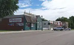 Downtown Plato | |
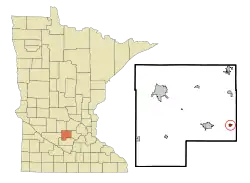 Location of Plato within McLeod County, Minnesota | |
| Coordinates: 44°46′21″N 94°02′23″W[1] | |
| Country | United States |
| State | Minnesota |
| County | McLeod |
| Area | |
| • Total | 0.35 sq mi (0.91 km2) |
| • Land | 0.35 sq mi (0.90 km2) |
| • Water | 0.01 sq mi (0.01 km2) |
| Elevation | 994 ft (303 m) |
| Population (2020) | |
| • Total | 329 |
| • Density | 948.13/sq mi (366.30/km2) |
| Time zone | UTC-6 (Central (CST)) |
| • Summer (DST) | UTC-5 (CDT) |
| ZIP code | 55370 |
| Area code | 320 |
| FIPS code | 27-51460[3] |
| GNIS feature ID | 2396225[1] |
History
A post office called Plato has been in operation since 1858.[5] The city was named for Plato, a Greek philosopher.[6]
Geography
According to the United States Census Bureau, the city has a total area of 0.36 square miles (0.93 km2), of which 0.35 square miles (0.91 km2) is land and 0.01 square miles (0.03 km2) is water.[7]
The community lies one half mile north of U.S. Highway 212 on a county road between Glencoe to the west and Norwood to the east. Buffalo Creek flows past the northwest of the community and the dry Kinneson Lakebed lies to the east and northeast.[8]
Demographics
| Census | Pop. | Note | %± |
|---|---|---|---|
| 1880 | 49 | — | |
| 1890 | 130 | 165.3% | |
| 1900 | 232 | 78.5% | |
| 1910 | 238 | 2.6% | |
| 1920 | 251 | 5.5% | |
| 1930 | 242 | −3.6% | |
| 1940 | 283 | 16.9% | |
| 1950 | 263 | −7.1% | |
| 1960 | 280 | 6.5% | |
| 1970 | 303 | 8.2% | |
| 1980 | 390 | 28.7% | |
| 1990 | 355 | −9.0% | |
| 2000 | 336 | −5.4% | |
| 2010 | 320 | −4.8% | |
| 2020 | 329 | 2.8% | |
| U.S. Decennial Census[9] | |||
2010 census
At the 2010 census,[10] there were 320 people, 139 households and 97 families residing in the city. The population density was 914.3 inhabitants per square mile (353.0/km2). There were 146 housing units at an average density of 417.1 per square mile (161.0/km2). The racial makeup of the city was 98.1% White, 0.3% Native American, 0.6% Asian, and 0.9% from other races. Hispanic or Latino of any race were 0.9% of the population.
There were 139 households, of which 23.0% had children under the age of 18 living with them, 61.9% were married couples living together, 4.3% had a female householder with no husband present, 3.6% had a male householder with no wife present, and 30.2% were non-families. 23.7% of all households were made up of individuals, and 8.7% had someone living alone who was 65 years of age or older. The average household size was 2.30 and the average family size was 2.72.
The median age was 44.6 years. 18.7% of residents were under the age of 18; 3.7% were between the ages of 18 and 24; 28.2% were from 25 to 44; 31.6% were from 45 to 64; and 17.8% were 65 years of age or older. The population was 50.6% male and 49.4% female.
2000 census
At the 2000 census,[3] there were 336 people, 144 households and 99 families residing in the city. The population density was 985.0 inhabitants per square mile (380.3/km2). There were 145 housing units at an average density of 425.1 per square mile (164.1/km2). The racial makeup of the city was 98.81% White, 0.60% Asian, and 0.60% from two or more races.
There were 144 households, of which 29.9% had children under the age of 18 living with them, 61.1% were married couples living together, 7.6% had a female householder with no husband present, and 31.3% were non-families. 22.9% of all households were made up of individuals, and 11.8% had someone living alone who was 65 years of age or older. The average household size was 2.33 and the average family size was 2.76.
22.6% of the population were under the age of 18, 6.3% from 18 to 24, 32.1% from 25 to 44, 24.1% from 45 to 64, and 14.9% who were 65 years of age or older. The median age was 38 years. For every 100 females, there were 97.6 males. For every 100 females age 18 and over, there were 94.0 males.
The median household income was $55,179 and the median family income was $62,917. Males had a median income of $36,250 compared with $29,018 for females. The per capita income was $24,434. None of the families and 2.8% of the population were living below the poverty line, including no under eighteens and 7.1% of those over 64.
References
- U.S. Geological Survey Geographic Names Information System: Plato, Minnesota
- "2020 U.S. Gazetteer Files". United States Census Bureau. Retrieved July 24, 2022.
- "American FactFinder". United States Census Bureau. Archived from the original on February 12, 2020. Retrieved January 31, 2008.
- "2010 Census Redistricting Data (Public Law 94-171) Summary File". American FactFinder. United States Census Bureau. Retrieved April 27, 2011.
- "McLeod County". Jim Forte Postal History. Retrieved July 19, 2015.
- Upham, Warren (1920). Minnesota Geographic Names: Their Origin and Historic Significance. Minnesota Historical Society. p. 318.
- "US Gazetteer files 2010". United States Census Bureau. Archived from the original on July 2, 2012. Retrieved November 13, 2012.
- Plato, MN, 7.5 Minute Topographic Quadrangle, USGS, 2016
- "Census of Population and Housing". Census.gov. Retrieved June 4, 2015.
- "American FactFinder". United States Census Bureau. Archived from the original on February 12, 2020. Retrieved November 13, 2012.
Municipalities and communities of McLeod County, Minnesota, United States | ||
|---|---|---|
| Cities | 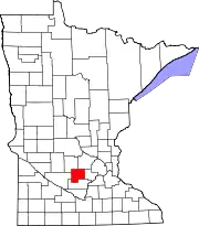 Map of Minnesota highlighting McLeod County | |
| Townships | ||
| Unincorporated communities | ||
| Ghost town | ||