Pomona, Queensland
Pomona is a rural town and locality in the Shire of Noosa, Queensland, Australia.[2][3] In the 2016 census the locality of Pomona had a population of 2,910 people.[1] Pomona is located around 135 kilometres north of Brisbane. It is located at the base of Mount Cooroora (439 meters) at the northern end of the Sunshine Coast.
| Pomona Sunshine Coast, Queensland | |||||||||||||||
|---|---|---|---|---|---|---|---|---|---|---|---|---|---|---|---|
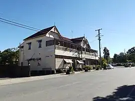 Pomona Hotel in 2012 | |||||||||||||||
 Pomona | |||||||||||||||
| Coordinates | 26.3659°S 152.8549°E | ||||||||||||||
| Population | 2,910 (2016 census)[1] | ||||||||||||||
| • Density | 54.09/km2 (140.1/sq mi) | ||||||||||||||
| Established | 1890 | ||||||||||||||
| Postcode(s) | 4568 | ||||||||||||||
| Elevation | 102 m (335 ft) | ||||||||||||||
| Area | 53.8 km2 (20.8 sq mi) | ||||||||||||||
| Time zone | AEST (UTC+10:00) | ||||||||||||||
| Location |
| ||||||||||||||
| LGA(s) | Shire of Noosa | ||||||||||||||
| State electorate(s) | |||||||||||||||
| Federal division(s) | Wide Bay | ||||||||||||||
| |||||||||||||||
Geography

The locality of Pomona is bounded to the south by the Bruce Highway and along most of its northern boundary by Six Mile Creek.[4]
The North Coast railway line passes through the locality from the south-east to the north-west, with the town served by the Pomona railway station (26.3661°S 152.8567°E).[4][5] Yurol railway station is an abandoned railway station on the line (26.3943°S 152.8875°E).[5]
The township of Pomona is surrounded by rural residential acreage properties and small farms. A significant portion of the locality is within Yurol State Forest,[4] a legacy of days past when the town once was a centre of forestry activities. The forest is now preserved as koala habitat.
Mount Cooroora is in the south-west of the locality (26.3713°S 152.8380°E), rising to 439 metres (1,440 ft).[6] It is a high intrusive volcanic plug within the Tuchekoi National Park.[7] It is approximately 2 kilometres (1.2 mi) south-west of the town.[4] The surrounding area is of high importance to Aboriginal people and there are many sites of Indigenous cultural importance across the region. Mount Cooroora has significant landscape, social and economic values to the town, while its vertical columns are an attraction to geologists. It is a popular site in the cooler months for visiting tourists climbing to the summit to appreciate excellent views looking east to the Sunshine Coast and west into the Mary Valley. Hikers, horse riders and mountain bike riders use the excellent trail network at its base.[8]
Pomona is within the Noosa Biosphere recognised by the United Nations Economic, Scientific and Cultural Organization (UNESCO) in 2007 as a World Biosphere Reserve.[9][10]
History
Pomona was first settled by Europeans in the late 1880s, but had been home to the Kabi Kabi/Gubbi Gubbi indigenous peoples for thousands of years before that.[11]
Early settlers collected timber from the area.[12] The railway to Pomona commenced operation in 1891, opening the land to farming.[12]
Pinbarren Provisional School opened on 1 August 1897 and was originally located on Reserve Street near the business centre of the town, in what is now called Stan Topper Park. On 1 January 1909 it became Pomona State School. From 1945 the school included a secondary department (Grades 8-10). In 1976 the school was relocated to Station Street.[13][14]
The town and railway station were originally called Pinbarren in 1899, then renamed Curara, and renamed Pomona in 1900, after the Roman goddess of fruit and orchards.[2][3][15]
Many of the town streets were named after the functions of buildings located along them including Ambulance Street, Church Street, School Street, Rectory Street, Hospital Street, Pottery Street and Factory Street.
The early colonial dairy industry at Pomona was replaced by a patchwork of small cropping farms.
The town became the administrative centre of the Noosa Shire Council when it was established in 1910. However, on 1 December 1980 the Council chambers moved to Tewantin. The original headquarters for the Shire, which were constructed in 1911, are now used by the Cooroora Historical Society and Noosa Shire Museum. The main streets of the town were devastated by fires in 1939 and 1942.[12] Many buildings were re-constructed with brick or in the "Art Deco" architectural style of the era.[16] Colonial buildings are also a feature of the town and can be viewed along a signed history walk.[17]
The state electoral district to which Pomona was part of from 1912 until 1992 was named Cooroora. The seat was renamed Noosa following the 1991 electoral district's re-shuffle. Pomona is in the Wide Bay federal electoral division.
Pomona Methodist Church opened on 26 March 1921 by the Reverend Henry Youngman.[18] In 1925, the Methodist Church building at Kareewa was relocated to behind the Pomona Methodist Church to be used as the church hall.[19] In 1977 the Methodist Church amalgamated into the Uniting Church in Australia and the church in Pomona became the Pomona Uniting Church.[20]
On Sunday 30 March 1949, Archbishop James Duhig laid the foundation stone for St Patrick's Catholic Primary School (26.3664°S 152.8517°E).[21] Duhig returned on Sunday 30 November 1947 to bless and open the school, which was operated by the Presentation Sisters.[22][23] The school closed in 1971.[13]
In 1996, the Pomona State School's secondary department moved to Summit Road, where it was renamed Cooroora Secondary College in 1997. In 2007 it was amalgamated with the Noosa District State High School in Cooroy to create a two-campus school with the junior secondary school being conducted on the Pomona campus and the senior secondary school on the Cooroy campus.[13]
Pinbarren Community Christian College opened on 10 February 2003.[13]
Historically and currently Pomona is within local government area of Shire of Noosa, but between 2008 and 2013 Pomona (and the rest of the Shire of Noosa) was within Sunshine Coast Region.[24][25][26]
At the 2011 census, Pomona had a population of 2,587 people, growing to 2910 in 2016.[27]
In the 2016 census, the locality of Pomona had a population of 2,910 people.[1]
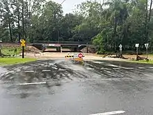
The 2022 South East Queensland flood saw significant flooding around Pomona. 450mm of rainfall was recorded from 24–25 February, the second-highest in the state;[28][29] it reached 786mm later on 25 February,[30] and more than 1,000mm by 26 February.[31]
Heritage listings
Pomona is Noosa Shire's 'living heritage town'. It has a number of heritage-listed sites, including:
- 3 Factory Street (26.3655°S 152.8576°E): Majestic Theatre[32]
- Red Street (26.3634°S 152.8541°E): Courthouse & former Pomona Police Station, Residence & Lockup[33]
- 9 Station Street (26.3671°S 152.8569°E): Cooroora Masonic Temple[34]
Economy
Pomona is a service centre for a town and regional population of 8000 people. The largest employer in Pomona is Noosa and District Landcare, which provides its environmental conservation services across South-East Queensland. Some farms produce edible goods for South-East Asia markets. To promote rural-based tourism, Noosa Council and Tourism Noosa have devised a 'Noosa Country Drive' through the picturesque rolling countryside and small hinterland towns, including Pomona. The town is seeking to diversify its economy further through adventure and recreational tourism, utilizing the surrounding national parks, forests and trail network. The 50 km2 Lake Cootharaba and Noosa Everglades are a 20-minute drive away.
Hinterland agri-business is fostered by Country Noosa, whose aim is to promote sustainable agriculture, horticulture and other rural enterprises in the area.[35]
As lifestyle industries continue to establish and flourish, a gin-making facility has opened in the town. Pomona hopes to grow as a centre for mountain biking, along the trails surrounding Mt Cooroora, which lies a short walk from the business centre. The Cooroora Trail between Cooran and Pomona was upgraded recently at a cost of $1.6 million. Pomona has been named the Noosa Biosphere Trails 'hub town'.
Education
Pomona State School is a government primary (Prep-6) school for boys and girls at 74 Station Street (26.3679°S 152.8606°E).[36][37] In 2018, the school had an enrolment of 303 students with 25 teachers (20 full-time equivalent) and 15 non-teaching staff (10 full-time equivalent).[38]
Noosa District State High School - Pomona Campus is a government secondary (7-12) school for boys and girls with two campuses, one at 120 Summit Road, Pomona (26.3531°S 152.8631°E), for Years 7-8 and the other at Tulip Street in Cooroy for Years 9-12. In 2016, the school had a total enrolment of 1,335 students with 111 teachers (106 full-time equivalent) and 48 non-teaching staff (40 full-time equivalent).[39]
Amenities
The Shire of Noosa operates a library service on a weekly schedule at the corner of Reserve Street and Memorial Avenue.[40]
There is a community swimming pool (currently closed) at the primary school, squash and tennis courts, a lawn bowls club and a full range of retail facilities in town, including a chemist. Ambulance and fire stations sit adjacent to each other at the centre of town.
Cooroy Pomona Uniting Church is at 27 Factory Street (26.3635°S 152.8562°E).[20][41][42]
Events

The 100 km Noosa Trail Network of walking tracks through the surrounding forests, farmlands and villages is popular with visitors, but especially every second October when the Great Noosa Trail Walk is held.[43] Visitors may also walk to the top of Mount Cooroora, the solidified lava plug of an ancient volcano worn away over time. Every July, thousands of people cheer 100 runners who race to the top of the mountain and back in under 30 minutes in the annual King of the Mountain.[44] In the past, those not fit enough to race up the mountain participated in 'billy cart' races or the world thong throwing championships (thongs of the footwear variety) with the rules stating that a size 10 thong, or larger, was required. As at 2010, the record throw was 42.8 meters.[45]
The district's rural roots are celebrated every September with the staging of the annual "show" (county fair). The Noosa Country Show has been a local institution since 1909.[46]
Local food and craft markets are held every Saturday morning. Every month, environmentally aware enthusiasts collect and distribute seeds of native plants. A weekly swap of home-grown food is another activity enthusiastically embraced, as is permaculture.[47]
Attractions
Pomona is notable for three things: a relaxed streetscape of distinctive timber and art deco buildings, the heritage-listed Majestic Theatre and the annual King of the Mountain race up the nearby Mount Cooroora in the Tuchekoi National Park.[48] The Majestic, built in 1921, is claimed to be the world's oldest continuously operating silent movie theatre built for that purpose. However, it is not the first theatre in the world in which silent films were screened. The Majestic has been a community-owned enterprise since October 2006.[32]
Australian musician Darren Hanlon's album "Fingertips and Mountaintops" was entirely recorded in the Majestic Theatre.[49]
The Noosa Shire Museum contains objects, photographs and historic documents that explain much of the early history of the area.[50] It is also a Keeping Place of indigenous sacred objects.[51] The old Pomona Railway Station has been moved to the other side of the railway tracks to become the Railway Station Art Gallery.[52]
References
- Australian Bureau of Statistics (27 June 2017). "Pomona (SSC)". 2016 Census QuickStats. Retrieved 20 October 2018.
- "Pomona – town in Shire of Noosa (entry 27282)". Queensland Place Names. Queensland Government. Retrieved 20 July 2021.
- "Pomona – locality in Shire of Noosa (entry 49434)". Queensland Place Names. Queensland Government. Retrieved 20 July 2021.
- "Queensland Globe". State of Queensland. Retrieved 24 October 2021.
- "Railway stations and sidings - Queensland". Queensland Open Data. Queensland Government. 2 October 2020. Archived from the original on 5 October 2020. Retrieved 5 October 2020.
- "Mount Cooroora – mountain in Shire of Noosa (entry 8316)". Queensland Place Names. Queensland Government. Retrieved 20 July 2021.
- "About Tuchekoi". Department of National Parks, Recreation, Sport and Racing. 31 January 2013. Archived from the original on 23 June 2015. Retrieved 29 July 2013.
- "Tuchekoi National Park and Tuchekoi Forest Reserve Management Statement 2013" (PDF). Parks and forests. Queensland Government. Archived (PDF) from the original on 24 October 2021. Retrieved 24 October 2021.
- "Noosa Biosphere". Noosa Shire Council. Archived from the original on 26 August 2015. Retrieved 3 September 2015.
- "Biosphere Reserve Information: Australia: Noosa". UNESCO. 26 January 2015. Archived from the original on 20 January 2016. Retrieved 3 September 2015.
- "Lands". gubbigubbi.com. Archived from the original on 12 April 2015. Retrieved 3 September 2015.
- Environmental Protection Agency (Queensland) (2000). Heritage Trails of the Great South East. State of Queensland. p. 144. ISBN 0-7345-1008-X.
- Queensland Family History Society (2010), Queensland schools past and present (Version 1.01 ed.), Queensland Family History Society, ISBN 978-1-921171-26-0
- "Pomona State School". Queensland State Archives. Archived from the original on 12 June 2018. Retrieved 8 June 2018.
- "Fruit Growing on Gympie". Gympie Times and Mary River Mining Gazette (Qld. : 1868 - 1919). Qld.: National Library of Australia. 16 October 1900. p. 3. Archived from the original on 26 November 2020. Retrieved 3 September 2015.
- "About Pomona". About Pomona. Archived from the original on 13 March 2017. Retrieved 30 October 2016.
- "WALK Pomona set to be launched at Heritage Showcase". Sunshine Coast Regional Council. 18 May 2012. Archived from the original on 30 October 2016. Retrieved 30 October 2016.
- "NEW METHODIST CHURCH". The Telegraph. No. 15084. Queensland, Australia. 2 April 1921. p. 7. Archived from the original on 14 July 2022. Retrieved 25 October 2021 – via National Library of Australia.
- "Pomona". Nambour Chronicle And North Coast Advertiser. Vol. XXII, no. 1136. Queensland, Australia. 14 August 1925. p. 3. Retrieved 11 October 2023 – via National Library of Australia.
- "Pomona Uniting Church". Churches Australia. Archived from the original on 24 October 2021. Retrieved 24 October 2021.
- "NEW CONVENT SCHOOL AT POMONA". Nambour Chronicle And North Coast Advertiser. No. 2232. Queensland, Australia. 28 March 1947. p. 7. Archived from the original on 14 July 2022. Retrieved 25 October 2021 – via National Library of Australia.
- "St. Patrick's Pomona School Opening". Nambour Chronicle And North Coast Advertiser. No. 2267. Queensland, Australia. 28 November 1947. p. 2 (SUPPLEMENT TO THE NAMBOUR CHRONICLE). Archived from the original on 14 July 2022. Retrieved 25 October 2021 – via National Library of Australia.
- "Pomona R.C. School Opening". Nambour Chronicle And North Coast Advertiser. No. 2269. Queensland, Australia. 12 December 1947. p. 5. Archived from the original on 14 July 2022. Retrieved 25 October 2021 – via National Library of Australia.
- "About Noosa". Noosa Shire Council. Archived from the original on 29 February 2020. Retrieved 24 October 2021.
- "Backward Glance: History of Local Government on the Sunshine Coast". Sunshine Coast Regional Council. Retrieved 2 August 2023.
- "The Noosa De-amalgamation: Building a New Organisation". Noosa Shire Council. 2 January 2014. pp. 8–9. Retrieved 2 August 2023.
- Australian Bureau of Statistics (31 October 2012). "Pomona". 2011 Census QuickStats. Retrieved 3 September 2015.
- "Queensland's wet weather continues with more than 400mm of rain falling in three hours, flood warnings issued". ABC News. Australian Broadcasting Corporation. 25 February 2022. Archived from the original on 25 February 2022. Retrieved 26 February 2022.
- Cassidy, Caitlin (25 February 2022). "Life-threatening floods forecast for Queensland as Sydney records wettest summer in 30 years". The Guardian. Archived from the original on 25 February 2022. Retrieved 26 February 2022.
- Doyle, Kate (25 February 2022). "Wet weekend weather for Queensland and NSW as cyclone brews in north-west, BOM says". ABC News. Australian Broadcasting Corporation. Archived from the original on 25 February 2022. Retrieved 26 February 2022.
- Eaton, Matthew (26 February 2022). "Heavy downpours, Wivenhoe rising rapidly". ABC News. Australian Broadcasting Corporation. Archived from the original on 26 February 2022. Retrieved 26 February 2022.
- "Majestic Theatre (entry 602696)". Queensland Heritage Register. Queensland Heritage Council. Retrieved 14 July 2013.
- "Pomona Police residence (& former station), lock-up and working Magistrates Court (courthouse) (entry 602515)". Queensland Heritage Register. Queensland Heritage Council. Retrieved 14 July 2013.
- "Cooroora Masonic Temple (former) (entry 602423)". Queensland Heritage Register. Queensland Heritage Council. Retrieved 14 July 2013.
- "About - Country Noosa". countrynoosa.com. Archived from the original on 5 February 2017. Retrieved 24 June 2018.
{{cite web}}: CS1 maint: unfit URL (link) - "State and non-state school details". Queensland Government. 9 July 2018. Archived from the original on 21 November 2018. Retrieved 21 November 2018.
- "Pomona State School". Archived from the original on 15 March 2020. Retrieved 21 November 2018.
- "ACARA School Profile 2018". Australian Curriculum, Assessment and Reporting Authority. Archived from the original on 27 August 2020. Retrieved 28 January 2020.
- "Annual Report 2016" (PDF). Noosa District State High School. Archived from the original (PDF) on 17 October 2017. Retrieved 17 October 2017.
- "Noosa Mobile Library - Mobile Stops - Noosa Mobile Hours". Shire of Noosa. Archived from the original on 30 January 2018. Retrieved 19 January 2018.
- "Find a Church". Uniting Church in Australia, Queensland Synod. Archived from the original on 24 October 2020. Retrieved 22 November 2020.
- "Cooroy Pomona". Mary Burnett Presbytery. Archived from the original on 22 May 2021. Retrieved 12 September 2021.
- "Great Noosa Trail Walk". Archived from the original on 30 October 2016. Retrieved 30 October 2016.
- "Pomona King of the Mountain". Archived from the original on 2 May 2013. Retrieved 30 October 2016.
- "Broome fails to crack thong throw record". Australian Broadcasting Corporation. 27 January 2010. Archived from the original on 30 October 2016. Retrieved 30 October 2016.
- "Pomona Showgrounds". Archived from the original on 30 October 2016. Retrieved 30 October 2016.
- "About - Country Noosa". Archived from the original on 5 February 2017. Retrieved 5 February 2017.
- "Pomona King of the Mountain Festival". The Cooroy & Pomona Lion's Club. Archived from the original on 2 May 2013. Retrieved 3 September 2015.
- "Biography". Darren Hanlon. Archived from the original on 29 January 2017. Retrieved 30 October 2016.
- "Noosa Museum". Noosa Museum. Archived from the original on 29 December 2016. Retrieved 24 October 2021.
- "Gubbi Gubbi". Noosa Museum. Archived from the original on 24 October 2021. Retrieved 24 October 2021.
- "Pomona Railway Station Gallery". Pomona Railway Station Gallery. Archived from the original on 24 October 2021. Retrieved 24 October 2021.
Further reading
- Page, Ruth (1970), The history of Pomona, Cooran, Kin Kin, Cootharaba, Skyrings Creek (PDF), archived (PDF) from the original on 14 November 2019
External links
![]() Media related to Pomona, Queensland at Wikimedia Commons
Media related to Pomona, Queensland at Wikimedia Commons
Geographical points of interest
- Former Pomona Hospital (26.3663°S 152.8531°E)
- Pomona Post Office (26.3656°S 152.8535°E)
- Former ANZ Bank (26.3659°S 152.8546°E)
- Former Pomona State School location, Current Pomona Kindergarten and main town park (26.3667°S 152.8541°E)
- Soldiers Memorial Park & King George V Memorial (26.3657°S 152.8550°E)
- Former Railway Hotel location (26.3659°S 152.8573°E)
- Pomona Hotel (26.3663°S 152.8559°E)